


Honor Award
A Strategic Master Plan for the Dead Sea
Dead Sea, Jordan
Sasaki Associates, Inc., Watertown, MA
Client: Jordan Development Zones Commission
 Close Me!
The dynamic mixed-use Corniche District is positioned sensitively around an existing grove of Tamarisk trees, which are enhanced to form a new ecological preserve. New public beaches offer free access to the water’s edge to residents and visitors alike
Download Hi-Res ImageImage: Saskai Associates
Image 1 of 16
 Close Me!
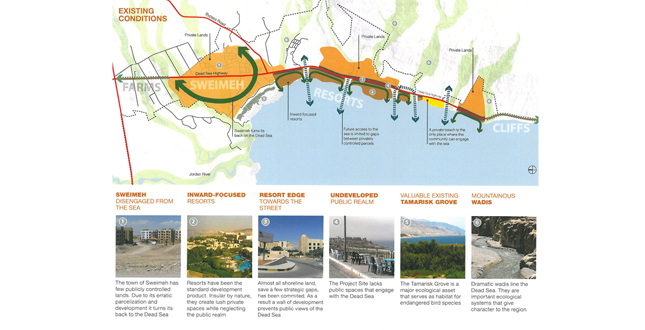
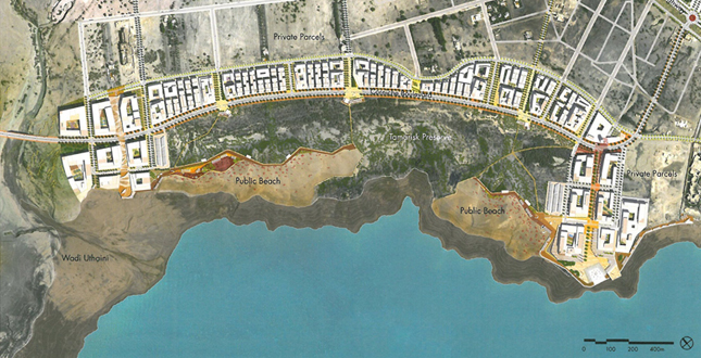
Strategic Interventions in Sweimeh and the Connection to the Sea.
Download Hi-Res ImageImage: Saskai Associates
Image 6 of 16
 Close Me!
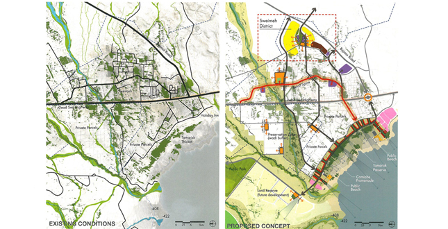
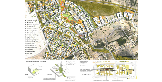
The Sweimeh District is integrated within a series of existing wadis (water channels) that have been preserved and enhanced as part of the public realm network. This sustainable network includes a generous new central park, pathways, shade structures, and active and passive recreation areas. Public facilities include a mosque, school, and a commercial district that forms the heart of this district. A range of housing types, job centers, and smaller scale public amenities are located in the surrounding neighborhoods.
Download Hi-Res ImageImage: Saskai Associates
Image 8 of 16
 Close Me!
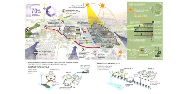
Sustainability Strategies: Sweimeh District.
Download Hi-Res ImageImage: Saskai Associates
Image 9 of 16
 Close Me!
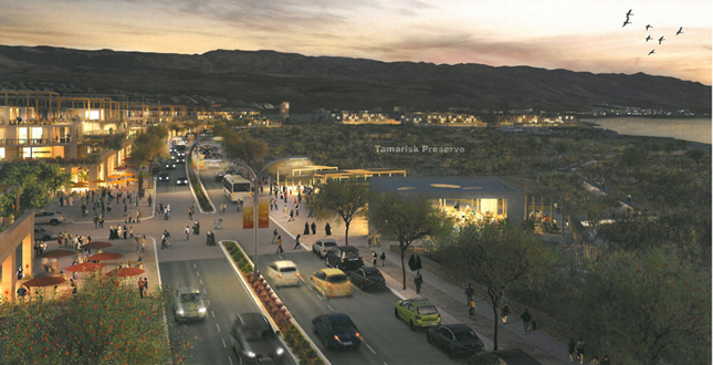
The Corniche District is characterized by pedestrian-oriented development, ecological conservation, and public access to the Dead Sea. The District overlooks the Tamarisk Preserve to the Sea and includes hotels, residences, shops, restaurants, and sensitively located public gathering spaces.
Download Hi-Res ImageImage: Saskai Associates
Image 11 of 16
 Close Me!
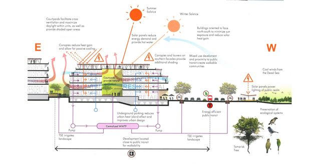
Sustainability Strategies: Corniche District.
Download Hi-Res ImageImage: Saskai Associates
Image 12 of 16
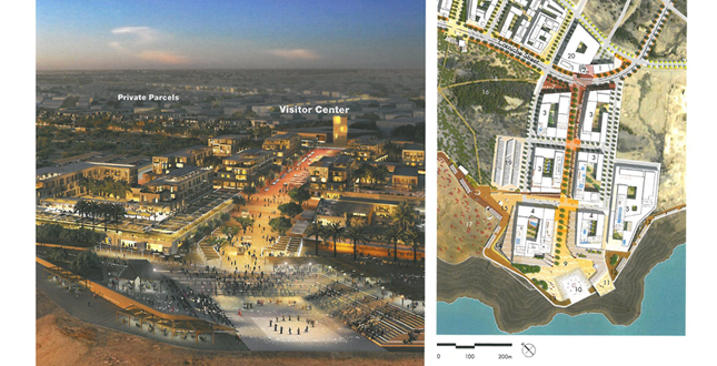
 Close Me!
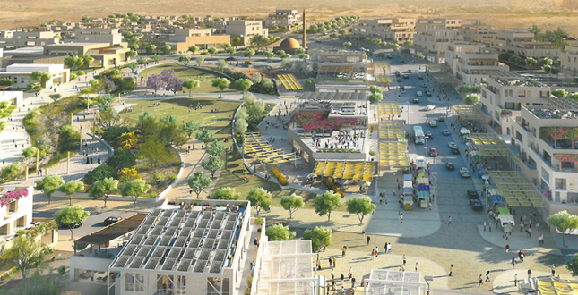
This view from the proposed Visitor Center emphasizes the strategic public realm approach of the Dead Sea Master Plan. Unique, sustainable, and climate specific public spaces are designed throughout the project to provide an identity and heart for the community.
Download Hi-Res ImageImage: Saskai Associates
Image 13 of 16
 Close Me!
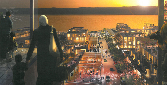
Visitors are drawn along a major outdoor public spine, between active blocks of shops and restaurants, to the Waterfront Plaza. The Plaza features a public amphitheater, seating areas, and stunning views of the Dead Sea.
Download Hi-Res ImageImage: Saskai Associates
Image 14 of 16
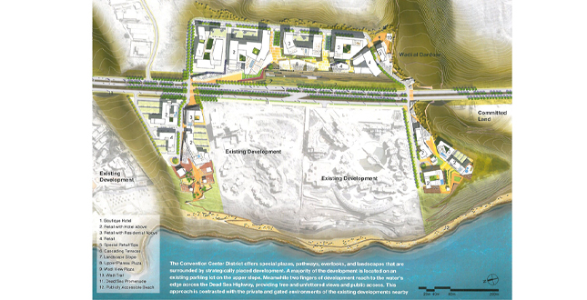 Close Me!
The Convention Center District offers special plazas, pathways, overlooks, and landscapes that are surrounded by strategically placed development. A majority of the development is located on an existing parking lot on the upper slope. Meanwhile two fingers of development reach to the water’s edge across the Dead Sea Highway, providing free and unfettered views and public access. This approach is contrasted with the private and gated environments of the existing developments nearby.
Download Hi-Res ImageImage: Saskai Associates
Image 15 of 16
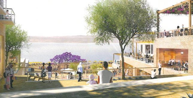 Close Me!
A new, layered public open space — framed by active uses of shops, cafes, and restaurants — is proposed as part of the Convention District. The space is integrated carefully within the existing topography, as it cascades down to the water’s edge. Views are maintained to the water, where the ever changing daylight is dynamically reflected across the surface of the Dead Sea.
Download Hi-Res ImageImage: Saskai Associates
Image 16 of 16
Project Statement
The Dead Sea Master Plan provides a sustainable, visionary plan that preserves and enriches the stunning ecology of the Sea; promotes no-build zones and integrated growth patterns; and encourages economic development that will benefit local communities. The comprehensive Master Plan includes landscape design, market analyses, and design guidelines, all based on climate and infrastructural realities. The Master Plan provides a powerful road map for sustainable future development at critical historic and cultural sites all across Jordan.
Project Narrative
—2012 Professional Awards Jury
The Kingdom of Jordan must take an innovative approach to economic development. To that end, the Government of Jordan has established a series of six “Development Zones” in which efforts are directed to increase foreign and domestic investment. The “Dead Sea Development Zone”, one among the six zones, encompasses 40 square kilometers of coastal land along the Dead Sea, the lowest body of water on earth and a stunning historic setting.
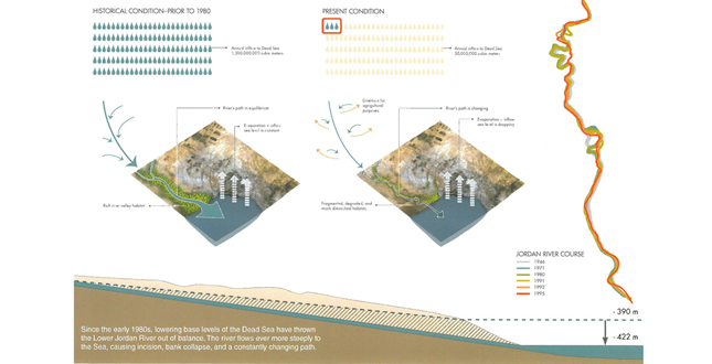
Challenges to development at the Dead Sea begin with a legacy of short-sighted planning efforts. An aggressive parcelization plan executed in the 1990s resulted in the disposition of hundreds of hectares of ecologically sensitive, culturally important, and economically valuable coastal land to developers at low prices with few restrictions. As a result, stretches of insular, private resorts now block views and access to the Sea. Most vacant coastal land has since been sold to developers, who plan to continue this pattern of exclusive privatization.
A lack of basic infrastructure and scarcity of resources
- primarily fresh water and waste treatment strategies
- further hinder development and pose immediate public health problems for the nearby existing community of Sweimeh, an economically depressed village to which tourist development has turned its back.
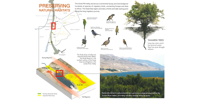
The Dead Sea’s many assets — which the current development pattern threatens — include health benefits, diverse and beautiful ecological systems, and an impressive cultural history. As part of the current planning effort, an extensive site analysis with a focus on the site’s natural systems has revealed both what attracts visitors to the Dead Sea and the critical measures needed to protect these assets from exploitation.
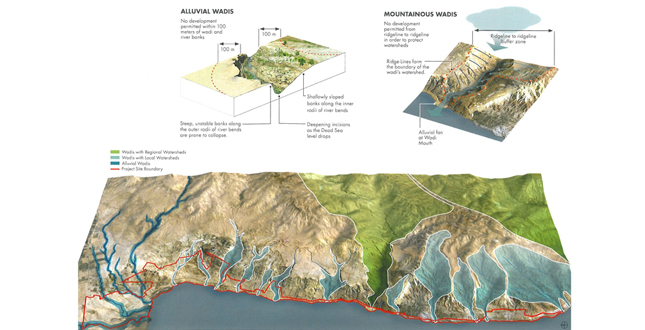
The first step in framing the Master Plan was the setting aside of ecologically sensitive land for conservation. Critical “no-build” zones included existing wadis and watersheds (mountainous and alluvial variety), ecologically sensitive warm water springs and vegetation, existing slopes greater than 25%, threatened Tamarisk tree species, and Important
Bird Areas (IBAs). The resulting conservation plan in concert with a developable land inventory forms the basis for sustainable, balanced interventions at the Dead Sea.
The Master Plan is then conceived as a series of districts, formed within this comprehensive landscape and conservation framework. Each district has its own mixed use ‘activity node’ providing a critical mass of services including public water access, views, vibrant street life and a range of development opportunities for all scales of investment from international developers to local businesses. A spectrum of sustainable infrastructure systems — an improved road network, public transportation, fresh water supply, waste water treatment, and utilities — stitch the districts together.
Emphasizing the Public Realm
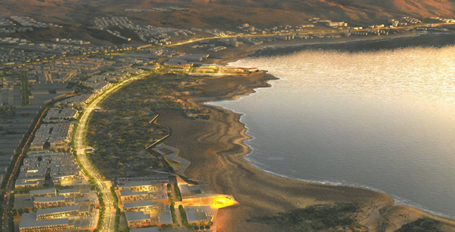
Critical to promoting a robust, sustainable economy at the Dead Sea is enhancing and improving all aspects of the public realm in a sustainable way. Fostering a vibrant public life and public interactions — outside the realm of private resort environments — affords visitors and residents opportunities to engage in public commerce, enjoy new public spaces and gathering areas, gain access the Sea, and foster a newfound sense of community. The proposed “Corniche District” — a dynamic mixed-use boulevard that forms an edge to a new ecological preserve and new public beaches — exemplifies these priorities.
Public services and amenities serve the entire site and are clustered in a new district adjacent to the village of Sweimeh, a small and struggling community of 4,200 residents. Much-needed public space, health care facilities, educational opportunities, affordable housing, and other industries and services initiate a critical mass of commercial activity. The development of the “Sweimeh District” diversifies the economic base of the Dead Sea and provides employment opportunities and services to residents.
Spatial and design priorities include promoting landscape connectivity and access to the Sea. Land to the east of the Dead Sea Highway is cut off from the water not only by a wall of privatized land and inwardly focused developments but by the busy Highway itself. The Master Plan identifies all available seaside parcels and proposes they be developed as mixed-use nodes focused on public open space and access to the Sea.
Proposed development near the cluster of resorts abutting the existing Convention Center demonstrates increased connectivity across the Dead Sea Highway and to the Sea itself. Available coastal parcels, wedged between large, insular resorts, provide a new model of development, respecting natural assets, incorporating open space, and welcoming commerce, public life, and pedestrian activity.
Sustainability strategies permeate the plan from a regional scale to a building scale. The scarcity of fresh water is addressed through a careful analysis of future supply and the introduction of measures to mitigate demand. A proposed centralized Waste Water Treatment Plant (WWTP) will recycle precious water for irrigation while solving basic public health and pollution problems caused by insufficient waste infrastructure.
Public transportation — within districts, throughout the site, and connecting to regional destinations — reduces reliance on private vehicles. At a district level, streets and blocks are laid out to minimize solar heat gain on buildings. At the building scale, guidelines informed by the Jordanian Green Building initiative promote sustainable strategies such as building shading, material selection, and xeric planting palettes that conserve resources while referencing regional design and enhancing a sense of place.
Project Resources
Infrastructure: Sigma
Marketing: Tetratech
Sustainability: Buro Happold