


Honor Award
Making a Wild Place in Milwaukee’s Urban Menomonee Valley
Milwaukee
Landscapes of Place, LLC, Mequon, WI
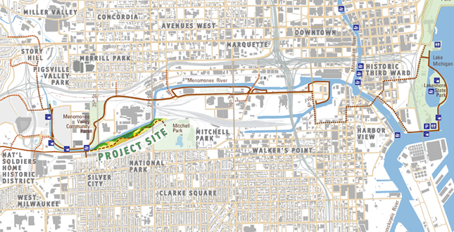 Close Me!
Site Plan, reclaiming a lost wild landscape and connecting it within the urban neighborhood context of Milwaukee's broad Menomonee River Valley.
Download Hi-Res ImageImage: Landscapes of Place, LLC
Image 1 of 15
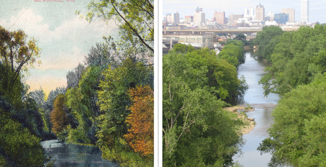 Close Me!
Valuing the opportunity provided by the persistence of a narrow sliver of ecological function, even when surrounded by ecologically depauperate lands.
Download Hi-Res ImageImage: Nancy M. Aten
Image 2 of 15
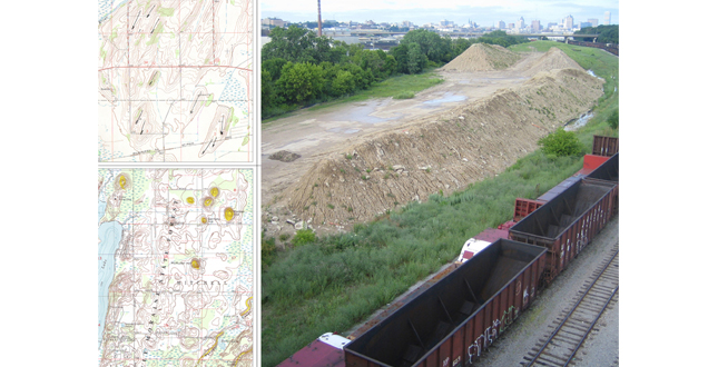 Close Me!
Regional drumlins, eskers and kames offer an irresistible solution to use the clay fill on site to accurately mimic glacial forms, making client-valued teachable references.
Download Hi-Res ImageImage: Nancy M. Aten
Image 3 of 15
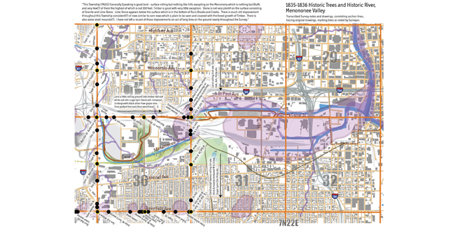 Close Me!
Overlaying pre-European-settlement land survey maps on present conditions, showing marshes, rivers, trails, and tree details – and therefore historic habitats.
Download Hi-Res ImageImage: Landscapes of Place, LLC
Image 4 of 15
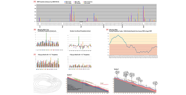 Close Me!
Analysis of irregular precipitation patterns in the Valley, underlining the importance of micro-topographic variability for successful vegetation establishment.
Download Hi-Res ImageImage: Landscapes of Place, LLC
Image 5 of 15
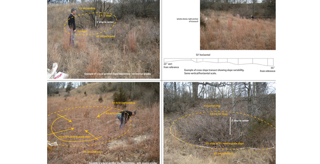 Close Me!
Combination of pictorial and quantitative analysis from reference sites effectively communicates to contractors the goals of micro-gradients and slope variability.
Download Hi-Res ImageImage: Nancy M. Aten
Image 6 of 15
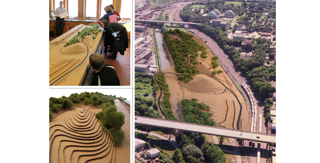 Close Me!
Tactile scaled models allow experiential mimicry and interaction with the dramatic topography to inform the design process and gather stakeholder perceptions.
Download Hi-Res ImageImage: Marc C. White (upper left), Nancy M. Aten (others)
Image 7 of 15
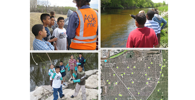 Close Me!
Practicing participatory restoration with schools in the two-mile radius of the Urban Ecology Center, envisioning repeated, deeper learning and action engagement.
Download Hi-Res ImageImage: Dan Collns (upper left), Nancy M. Aten (others)
Image 8 of 15
 Close Me!
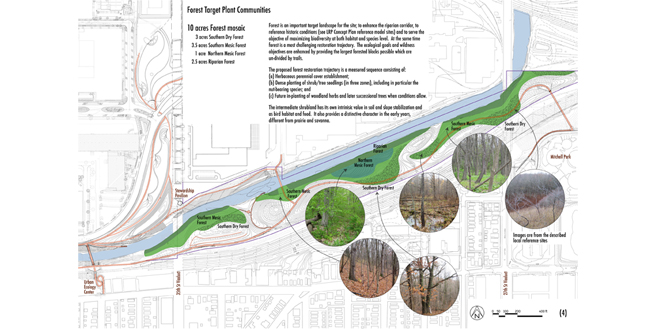
Within the 100-year vision, forested communities reference local sites, and have the advantage of the adjacent narrow riparian forest buffer. The intermediate shrubland stage of restoration is ecologically effective and also connects people with living, changing landscapes of beauty.
Download Hi-Res ImageImage: Nancy M. Aten
Image 9 of 15
 Close Me!
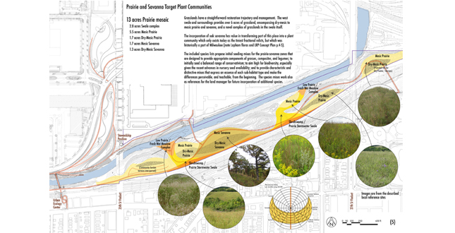
Target prairie and savanna communities reference local sites and respond to aspect, hydrology, and habitat needs. Sunlight patterns influenced spatial design to provide characteristic afternoon prairie backlighting. Habitat interaction with the trail acknowledges firebreak practicality and offers contemplative vistas.
Download Hi-Res ImageImage: Nancy M. Aten
Image 10 of 15
 Close Me!
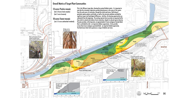
Overall matrix represents a comprehensive plan of target communities, the variability and distinctiveness within them, and experiential outcomes for the client.
Download Hi-Res ImageImage: Nancy M. Aten
Image 11 of 15
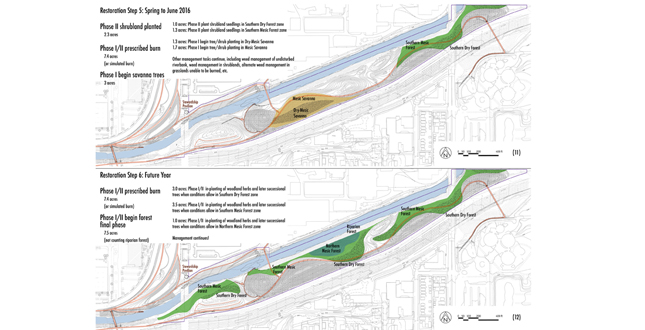
 Close Me!
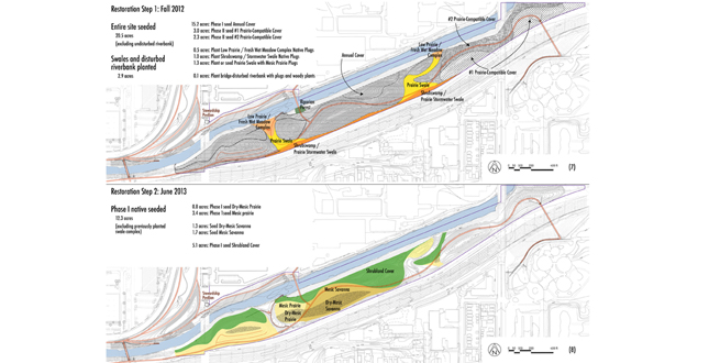
Step-by-step implementation sequences break down the plan by habitat zones, restoration trajectories, project phasing, and seasonal timing.
Download Hi-Res ImageImage: Landscapes of Place, LLC
Image 12 of 15
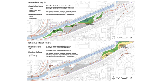 Close Me!
Modular, flexible plan reflects important sequences but offers time-and-resource sensitivity to real-world constraints, and structures the stewardship practice.
Download Hi-Res ImageImage: Landscapes of Place, LLC
Image 13 of 15
 Close Me!
Key to endurance is ongoing engagement with neighborhoods and families, who see the urban ecology working and recognize the beauty revealed by their work.
Download Hi-Res ImageImage: Landscapes of Place, LLC
Image 14 of 15
 Close Me!
Forgotten wilderness landscapes re-emerge.
Download Hi-Res ImageImage: Nancy M. Aten
Image 15 of 15
Project Statement
Demonstrating the opportunity to strengthen both urban and ecological qualities, the landscape restoration plan for the Menomonee Valley values wildness, delight, and learning with a strong ecological heart. Restoration of desecrated lands to a wild and healthy landscape along a still-resilient river promises transformation of both people and place through the process. The plan both reflects and develops the idea of restoration and education working together to make a place valued by the community.
Project Narrative
—2011 Professional Awards Jury
This is a place along a river that has been both invisible and inaccessible to people for decades. From the perspective of the river and of wildlife, it is also a place that has also been mistreated for a hundred and sixty years. A linear pocket of land is bordered on one side by the urban Menomonee River, in its last natural stretch before confinement downstream by sheet pile walls, and on the other side by the railroad. These 25 acres, two miles from the heart of downtown Milwaukee, provide tremendous opportunity for an idea that has emerged with much time, conversations, inspiring partners and eager neighborhoods: to make a significant wild place in this valley.
This land represents the final project stemming from the Menomonee Valley Master Plan of 2001, which described a revitalization plan for 140 acres of former industrial land. That plan enabled remediation of brownfield conditions, redevelopment of land to reestablish manufacturing jobs, and restoration of green space. Sustainability — ecologically, economically, and for the community, has been foremost in all efforts in the Valley.
Goals and Objectives
In a qualitative sense, the project creates a touchable 'wilderness' in the city; healing land and healing community. The overarching goal: to transform the irreversibly altered land and hydrologic conditions to a mosaic of biodiverse landscapes, including forest, prairie, and ephemeral wetland, native to Milwaukee and ecologically appropriate for new conditions, with systemic and meaningful engagement of the community. Guided throughout by the Society for Ecological Restoration’s planning framework, the project refined goals as follows:
1) Ecological Function, incorporating the fundamental ecological goals of recovering ecosystem integrity, health, and the potential for long-term sustainability; to foster successional trajectories toward long-term biotic goals. The plan provides working ecosystem services and habitat for fauna; both highly challenged by urban context. Particular attention is given to a “manageable” plan, that is capable of not ecologically crashing – to ensure there are no big setbacks if public lands management fails temporarily. 2) Learning. To provide from the beginning for deep environmental education, universally inclusive, engaging all senses. 3) Intrinsic Value of Nature. To express sense of place; to maximize biodiversity at both habitat and species level; to make examples of rare ecosystems (such as oak savanna). 4) Wildness. To enable individual discovery, in a landscape that provides clues to a deeper understanding and heightened awareness. To be a place with mystery that you want to explore, linger, hear, see, learn from. 5) Delight. The place looks and feels loved, it is “not like any other park”, and it can be intuitively appreciated. The landscape conveys an intentional, functional, healthy restoration process.
Analyses and Steps Along the Way
The Urban Ecology Center, a nationally-recognized environmental education and citizen science facility in Milwaukee, agreed to establish their third facility on the site. Their involvement is key to this plan, in the evolution of the project goals to fully support their work with neighborhood schools, but also the concept of "education that is participatory in large-scale environmental restoration."
Our experience across the river in implementing earlier phases of the master plan influenced analyses and details of this plan, particularly related to effective methods and techniques on the ground and in the Valley's abiotic conditions.
Natural history analysis identified the historic river course, hydrologic conditions, and historic vegetation. Contemporary local and regional assessed reference sites provided the link between historic natural conditions and current potential, and influenced long-term quantitative biodiversity and structure goals for proposed habitats.
Teaching patterns, including trail loops for young students and longer routes for older students, influenced habitat patch arrangement and interaction with the Trail. Comparisons of trail densities in nature centers and other urban trails influenced the stakeholders to reduce trail density, and led to emphasis on developing a significant forested block that is undivided by trail. Fauna habitat needs led to a significant contiguous grassland mosaic (whose scale is grasped from the Trail) that provides ephemerally wet habitats as well as adjacent forests.
Analysis of sun patterns with topographic aspects most directly influenced the habitat mosaic. Rainfall pattern assessments specific to this Valley affect the species mix and timing of species for vegetation establishment. This also led to the plan’s identification of the importance of and practical methods to achieve un-compacted soil profile (to 24") and microtopographic variability, in furrows and in cradle-knoll conditions, to support species survival.
Analysis of biotic conditions within the existing riparian forest, as well as imported weed seed in the acquired fill, led to vegetation management priorities, and the identification of best practices to minimize further weed import.
Analysis of adjoining neighborhoods, among the densest in the state, shows abundant schools within the two-mile teaching radius (facilitating after-school visits). Our experience working with three of those schools in participatory restoration on the other side of the river has influenced the breakdown of steps and the scale of phases that could effectively combine this kind of participation with contracted work.
The Plan
This is an ecological restoration plan. In addition to ecology, and those factors that influence the potential ecology, the plan conveys a vision of natural lands unexperienced by most urbanites. It envisions, analyzes and communicates the practical needs of bringing 'new' land into the public domain, of developing truly participatory restoration in conjunction with a key educational facility, and of restoring and managing the land over time with limited and unpredictable budgets.
The plan enumerates trajectories to establish prairie, oak savanna, and eventual forest as long-term goals. It describes innovative methods to achieve un-compacted soil structure and micro-topographic variability. The plan gives thorough descriptions of nine community types with 479 native species, which are viable ecologically, available, and manageable (for example, an initial seeding of 73 species in mesic prairie, with an eventual goal of 110). Reference sites and their floristic quality help give long-term guideposts. Within habitat types, character and species of visual essence are described, and the role of the landscape architect on-site in developing species patterns. Novel native plant assemblages are used in the flashy-river-influenced and stormwater-influenced areas to respond to those conditions effectively. Consideration is made for wildlife food and habitat through the seasons, especially the needs of migrating birds, endangered reptiles known to be on site and amphibians, which are a mainstay of this riparian corridor. Provision for layered, textured, variable, recognizable species and patterns is made to enrich the interaction of people and landscape. The plan incorporates flexibility, phasing, and a blending of contracted and community labor. Responsibilities for the land manager are identified (including seed collection and on-site plant nursery), the structure of a stewardship resources plan is discussed, with opportunities for UEC programming to develop its restoration framework.
In the domain of urban ecology, this project impacts both 'urban' and 'ecology.' It embeds a wild and healthy place along a still-resilient river in the city, accessible only by walking or biking, big enough to surround you with nature, and without designed structure that can draw attention from the real art... that of life. Ecological restoration values the next-door as well as the far-away. Design plays a strong role in restoration within the fabric of cities, in our next-door places, working out how to strengthen the relationships of people with nature to the sustained benefit of both.
Project Resources
Design: Landscapes of Place, LLC
Nancy M. Aten, ASLA,
Consultant: Landscapes of Place, LLC
Dan Collins, P.E.
Consultant: White Ecological
Marc C. White
Consultant: Darrel Morrison, FASLA
Technical Assistance: Department of Geosciences, University of Wisconsin - Milwaukee
Tom Hooyer; Bill Kean
Client Partnership
Rivet, LLC (Project Management)
Menomonee Valley Partners, Inc.
Redevelopment Authority of the City of Milwaukee
Wisconsin Department of Natural Resources
Urban Ecology Center
Friends of the Hank Aaron State Trail
Client’s Engineers
Alfred Benesch & Company, with:
Wenk Associates, Inc.
The Kubala Washatko Architects, Inc.
The Sigma Group
EMCS, Inc.
Gestra Engineering, Inc.
Great Lakes Ecological Services, LLC
Marek Landscaping, LLC
Mainstream Restoration, Inc.