


Honor Award
Riparian Urbanism
Haley Heard, Student Affiliate ASLA, Massachusetts Institute of Technology
Faculty Advisors: Alan Berger and Rahul Mehrotra
 Close Me!
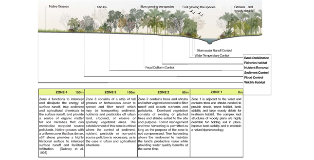
Riparian Buffer Physiology — Recommended Buffer Widths
Download Hi-Res ImagePhoto: Haley Heard
Photo 2 of 11
 Close Me!
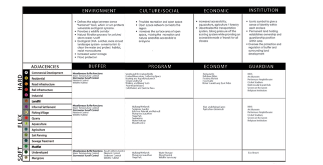
Riparian Buffer Architecture — Adjacent Land Uses
Download Hi-Res ImagePhoto: Haley Heard
Photo 4 of 11
 Close Me!
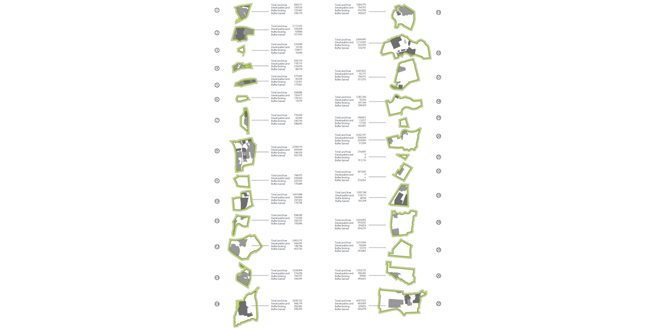
Buffer Acquisition Phasing Diagram — Conservative Surgery: Thane Creek has already experienced encroachment into ecologically sensitive areas, much of which resides within the buffer zone.
Download Hi-Res ImagePhoto: Haley Heard
Photo 6 of 11
 Close Me!
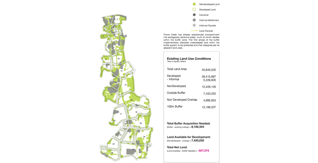
Buffer Acquisition Phasing Diagram — Conservative Surgery: The first phase of the buffer implementation allocates underdeveloped land within the buffer system to be protected and then designed per its adjacent land uses.
Download Hi-Res ImagePhoto: Haley Heard
Photo 7 of 11
 Close Me!
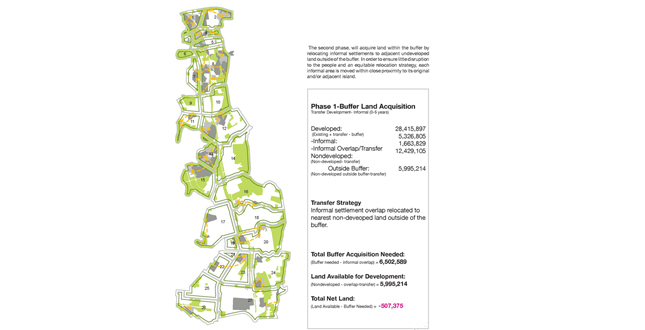
Buffer Acquisition Phasing Diagram — Conservative Surgery: The second phase, will acquire land within the buffer by relocating informal settlements to adjacent undeveloped land outside of the buffer. In order to ensure little disruption to the people and an equitable relocation strategy, each informal area is moved within close proximity to its original and/or adjacent island.
Download Hi-Res ImagePhoto: Haley Heard
Photo 8 of 11
 Close Me!
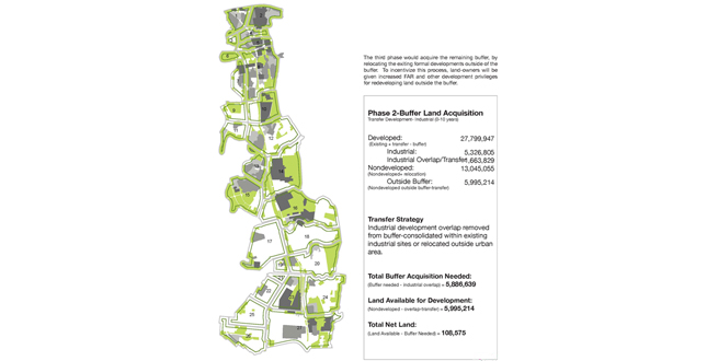
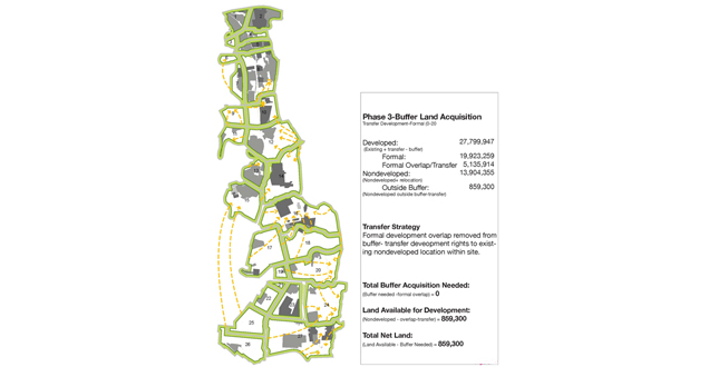
Buffer Acquisition Phasing Diagram — Conservative Surgery: The third phase would acquire the remaining buffer, by relocating the exiting formal developments outside of the buffer. To incentivize this process, land-owners will be given increased FAR and other development privileges for redeveloping land outside the buffer.
Download Hi-Res ImagePhoto: Haley Heard
Photo 9 of 11
Project Statement
Riparian Urbanism is a new urban model that illustrates how landscape can become the armature of our future cities. As the world develops, ecological systems become evermore threatened. In Mumbai, India rapid developments are a threat, but also a necessity. However, Riparian Urbanism provides a mechanism for protecting these systems, while allowing development to proceed more intelligently. This model achieves this by incentivizing development, while also providing valuable open space and protecting the ecological systems.
Project Narrative
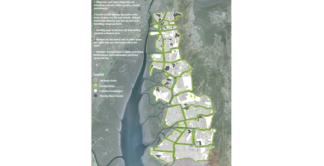
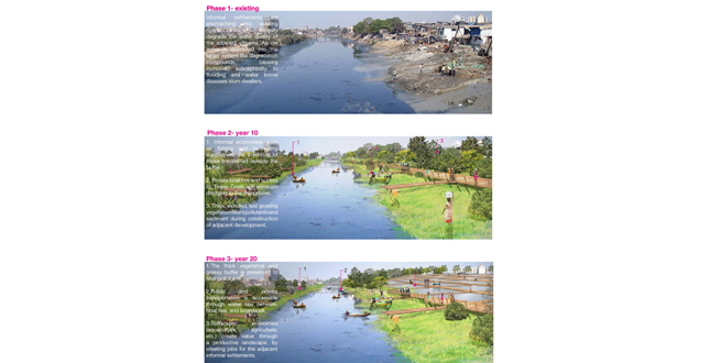
Ninety percent of the World’s megacities are built in sensitive coastal environments.Mumbai, India is the biggest of them all.The Bay of Mumbai was historically ringed with a diverse habitat of mangrove forests, but over the past decade it has lost forty percent of this ecosystem.The loss of mangrove forests has been linked to wider, more extreme environmental deterioration, flooding, hypoxia, disease outbreaks, and species extinction.
“Riparian Urbanism” is a model of urbanization that uses this existing coastal landscape and hydrology as the armature for development. Riparian Urbanism provides a mechanism for protecting and maintaining ecological systems in coastal areas, while allowing development to proceed more intelligently (not denying it). This type of urbanization gives privilege to the natural systems by regulating growth and density within districts, while creating a riparian buffer system along the waterways and entire mangrove forests of the Bay.
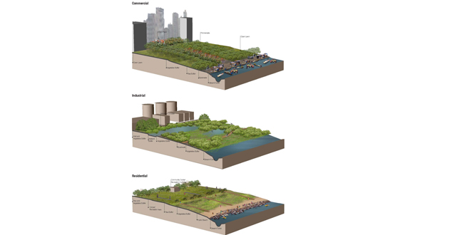
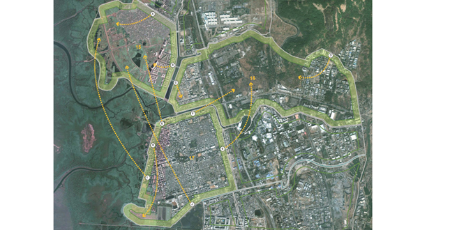
The riparian buffer system is a multidimensional strategy that allocates a maximum 100-meter buffer from every waterway for environmental, cultural, economic and transportation uses.The buffer width fluctuates depending on the program and adjacent land use.The buffer is designed to filter and protect the urban water system while providing contiguous wildlife habitat and corridors.Cultural program is layered ‘lightly’ onto the system to provide accessible and usable open space to all residents, and a variety of recreational experiences. In order to enhance its value, the buffer also consists of productive landscapes throughout to serve as an economic generator. Finally, the waterways are connected to create a new affordable and accessible water based transportation network.
The second part of the project creates an implementation strategy called “conservative surgery”, for acquiring new land justly. The area along Thane Creek has already experienced encroachment into ecologically sensitive areas, much of which resides within the allocated buffer zone. The first phase of implementation will allocate undeveloped land within the buffer system to be protected and then designed per its adjacent land uses.The second phase (Fig. 18) will acquire land within the buffer by relocating informal settlements to adjacent undeveloped land outside of the buffer.In order to ensure minimal disruption to the residents and an equitable land use relocation strategy, each informal area will be moved within its original and/or adjacent district.The third phase, will acquire the remaining buffer, by relocating the exiting formal developments outside of the buffer.To incentivize this process, landowners will be given increased FAR and other development privileges for redeveloping land outside the buffer.
The final urban form will immerse out of new management strategies that must compliment the design component of Riparian Urbanism.Design and management together will increase the likelihood of the riparian buffer success.By breaking down the non-hierarchical sprawl development into manageable districts, it is easier to build a sense of ownership by residents.Each district will have a guardianship program responsible for overseeing the protection of its buffer corridor.On a larger scale, the Bay’s ecosystem would have a management team that would oversee protection and maintenance of all the region’s buffers.Finally, if “Riparian Urbanism” strategy is instituted throughout the Bay, Mumbai could have a regional authority to protect all its coastal environments and tributaries, and all for the mangrove forests to grow and flourish.
Additional Project Credits
This project was designed at MIT under the Department of Urban Studies and Planning as a joint Urban Design Studio in DUSP's City Design and Development Group. Landscape + Urbanism — Around the Bay of Mumbai was the studio from which I was able to design it. Professor Alan Berger and Rahul Mehrotra co-advised me on this project.