


Honor Award
Alchemy of an Urban Estuary: Revealing and Transforming Infrastructure Along the Jones Falls Corridor
Sarah Noel Shelton, Student ASLA and Aja Justine Bulla-Richards, Student Affiliate ASLA,
University of Virginia
Faculty Advisors: Jorg Sieweke
 Close Me!
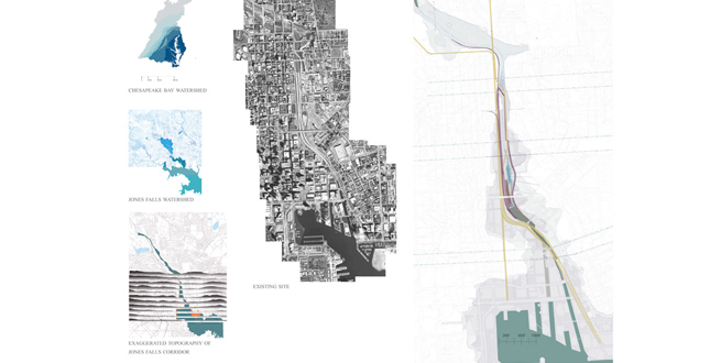
Site Plan
Download Hi-Res ImagePhoto: Sarah Noel Shelton and Aja Justine Bulla-Richards
Photo 1 of 16
 Close Me!
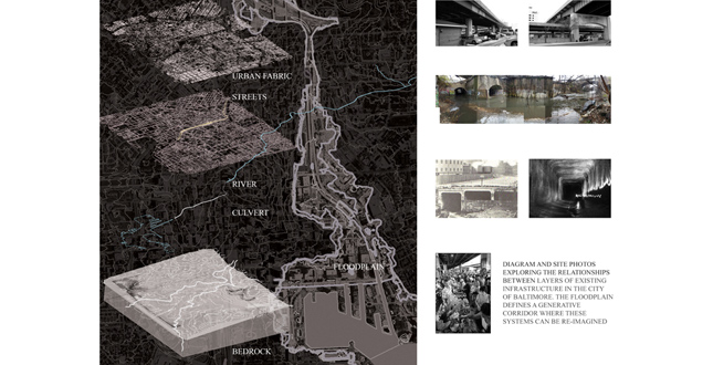
Diagram and site photos exploring the relationships between layers of existing infrastructure in the city of Baltimore. The floodplain defines a generative corridor where these systems can be re-imaged.
Download Hi-Res ImagePhoto: Sarah Noel Shelton and Aja Justine Bulla-Richards
Photo 2 of 16
 Close Me!
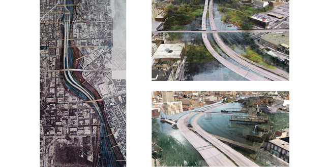
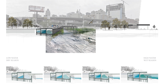
The River Reclaming the Jones Falls Corridor. Early site model and perspective studies considering sea level rise and increased flooding due to climate change. The final proposal defines room for the river to co-exist with the surrounding urban fabric.
Download Hi-Res ImagePhoto: Sarah Noel Shelton and Aja Justine Bulla-Richards
Photo 3 of 16
 Close Me!
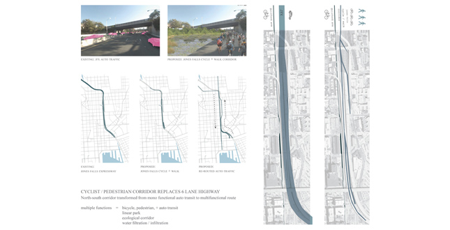
Cyclist/Pedestrian Corridor Replaces Six Land Highway. North-south corridor transformed from mono functional auto transit to multifunctional route.
Download Hi-Res ImagePhoto: Sarah Noel Shelton and Aja Justine Bulla-Richards
Photo 5 of 16
 Close Me!
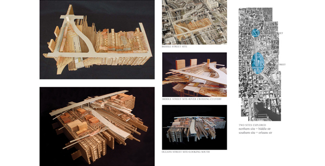
Crossing Flows + Layered Strata.Two Site Models: Biddle street site – culvert crosses from west side of corridor to east side, damming the river and causing it to cross the culvert Orleans Street site – bedrock and culvert are exposed adding to the existing strata of the decommissioned JFX highway and still functioning Orleans overpass.
Download Hi-Res ImagePhoto: Sarah Noel Shelton and Aja Justine Bulla-Richards
Photo 6 of 16
 Close Me!
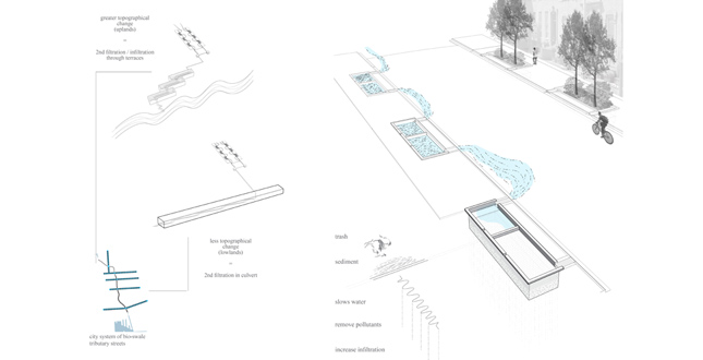
Baltimore Tributary Streets/First (In)filtration. Utilizing existing infrastructure and topography to filter storm water. Adapted infrastructure (streets, sidewalks, and culvert) become decentralized network of small moments of filtration / infiltration to reduce the amount of water and level of pollutants entering the larger waterways.
Download Hi-Res ImagePhoto: Sarah Noel Shelton and Aja Justine Bulla-Richards
Photo 7 of 16
 Close Me!
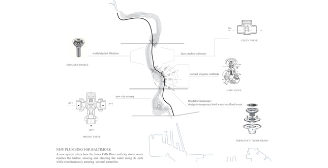
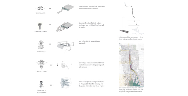
New Plumbing for Baltimore. A new system alters how the Jones Falls River and city storm water reaches the harbor, slowing and cleaning the water along its path while simultaneously creating cultural amenities.
Download Hi-Res ImagePhoto: Sarah Noel Shelton and Aja Justine Bulla-Richards
Photo 8 of 16
 Close Me!
New plumbing for Baltimore Download Hi-Res Image
Photo: Sarah Noel Shelton and Aja Justine Bulla-Richards
Photo 9 of 16
 Close Me!
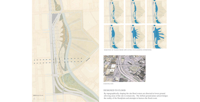
Designed to Flood. By topographically shaping the site flood waters are directed to lower ground allowing areas of the site to remain dry. The shifted ground plane acknowledges the reality of the floodplain and attempts to harness the flood event.
Download Hi-Res ImagePhoto: Sarah Noel Shelton and Aja Justine Bulla-Richards
Photo 10 of 16
 Close Me!
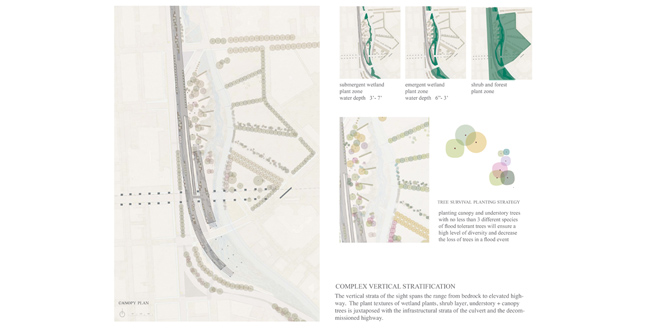
Complex Vertical Stratification. The vertical strata of the sight spans the range from bedrock to elevated highway. The plant textures of wetland plants, shrub layer, understory + canopy trees is juxtaposed with the infrastructural strata of the culvert and the decommissioned highway.
Download Hi-Res ImagePhoto: Sarah Noel Shelton and Aja Justine Bulla-Richards
Photo 11 of 16
 Close Me!
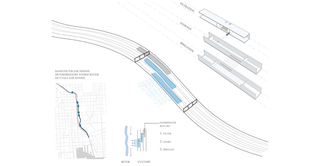
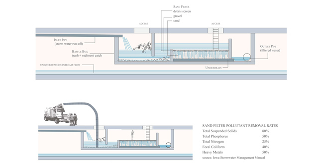
Sand filter locations determined by stormwater out fall locations Download Hi-Res Image
Photo: Sarah Noel Shelton and Aja Justine Bulla-Richards
Photo 12 of 16
 Close Me!
Culvert Filtration System/2nd Stage of Stormwater Cleansing. Utilize existing infrastructure to cleanse water as it is conveyed to the harbor. Retrofit culvert to filter storm water run-off at out fall locations trapping trash, sediment, and harmful nutrients.
Download Hi-Res ImagePhoto: Sarah Noel Shelton and Aja Justine Bulla-Richards
Photo 13 of 16
 Close Me!
Hydrolic Synergy. Multiple conduits perform in parallel for clean water and flood prevention. In times of drought the culver irrigates the river with filtered stormwater. During storms the culvert carries flashy water, protecting the urban fabric and the river ecosystem.
Download Hi-Res ImagePhoto: Sarah Noel Shelton and Aja Justine Bulla-Richards
Photo 11 of 16
 Close Me!
Section Perspective and Section Model Looking South Towards Downtown Baltimore. Section perspective and section model looking south towards downtown Baltimore. Layers of infrastructure including bedrock, the river, the culvert, and expressway structure weaver together becoming the fabric of public space.
Download Hi-Res ImagePhoto: Sarah Noel Shelton and Aja Justine Bulla-Richards
Photo 15 of 16
 Close Me!
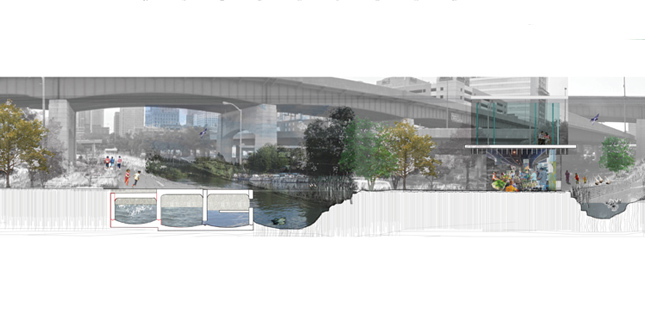
Section Perspective Under Orleans Avenue. This site is the current home of the Baltimore farmers market, the proposed island would continue to serve this function as well as provide collective spaces for performances, events, recreation and everyday journeys.
Download Hi-Res ImagePhoto: Sarah Noel Shelton and Aja Justine Bulla-Richards
Photo 16 of 16
Project Statement
This project transforms mono-functional infrastructure into multi-functional systems, addressing storm water issues and creating an identity for the largely uninhabited corridor that bisects Baltimore. The unique space proposed is comprised of a series of wetland parks, formed through revealing and adapting the layered history of the Jones Falls River and expressway. The once buried and problematic infrastructure is re-interpreted as regenerative space that supports ecological and cultural functions, engaging both sides of the city.
Project Narrative
Historical Context
The Jones Falls River was a primary resource for the city of Baltimore. As the city encroached on the territory of the river, filling in wetlands and destroying the estuary, floods threatened the downtown business district. After significant floods took many lives and destroyed valuable property, the river was channelized and eventually buried in a culvert. Presently The Jones Falls Expressway runs over and parallel to the underground river forming a physical and psychological barrier between east and west Baltimore. The city is considering various scenarios for removing all or part of the elevated expressway south of Penn Station. The decommissioning of the JFX opens up new possibilities for this underutilized corridor.
Ecological Issues
The Baltimore harbor suffers from very poor water quality; this is an ecological, cultural, and economic concern. The lower Jones falls watershed encompasses 58 square miles, composed primarily of highly impervious urban land. Currently the pollutants and trash that enter the stormwater in this region converge within the culvert and are released into the heart of Baltimore’s primary tourist attraction, the inner harbor. At a regional scale the ecology of the larger Chesapeake Bay is threatened by contaminates from the matrix of tributaries, such as Jones Falls that feed its waters. In this project the urban fabric of Baltimore is considered as part of this larger Estuary system.
Project Objectives
Reveal layers of existing infrastructure. Daylight the culvert under Fallsway Road, and divert the Jones falls river base flow. Expose the geomorphology of the corridor by uncovering the bedrock layer at grade with the base of the culvert.
Transform mono-functional systems to serve multiple purposes. The culvert that once confined the last mile of Jones Falls River now filters and stores stormwater, provides room for flashy water, irrigates the river, and becomes a boardwalk. The robust expressway structure supports multiple modes of transportation and shelters public events.
Generate public space where diverse flows intersect and overlap. The flood line can be understood as a generative edge, delineating a site for desirable and adaptable public space.
Urban Alchemy
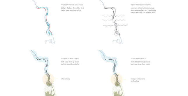
Baltimore’s culvert and topographical change are utilized to create manifold systems of filtration and infiltration. A network of landscape features such as check dams, constructed wetlands, and bio swales work in concert to detain, clean, and manage water. Street edge bioswales are introduced to filter storm water run-off before it reaches the culvert, effectively reducing the volume of water and concentration of pollutants that enter the Chesapeake Bay. Adaptive infrastructure functions as decentralized systems composed of small moments of filtration and infiltration. The three 20’x16’ concrete chambers of the culvert are retrofitted to clean, store, and distribute water. The first chamber contains baffle boxes to trap trash, while sand filters remove debris and pollutants cleaning storm water before it moves into the second chamber to be stored. Upon reaching capacity the water spills from the second chamber into a third. The final chamber opens towards the river allowing the filtered water to irrigate the stream. These new functions make the culvert a dynamic feature in the urban landscape. During storm events water will occasionally shoot up out of slots cut into the top of the concrete channel, and urban waterfalls will form along its edges. The culvert boardwalk becomes a destination for viewing multifarious hydraulic processes.
River water and brackish harbor water meet within the culvert. Flooding forces come from run-off during storms and also move up from the harbor. Our site acts as an estuary providing wetland habitat that improves the water quality, while increasing water storage capacity in flood events. The design also shapes public space, creating a stream environment with ecological and esthetic value in both high and low water conditions. The wetland extends into the adjacent land that is now a parking lot but is slotted for new development. Bio-filtration swales and micro-topography structure the ground so that new buildings can be sited within the floodplain.
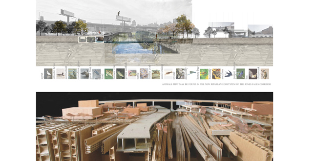
An island between the east and west sides of the river is sited under a portion of the expressway structure that is currently the location of the Baltimore farmers market. We are preserving this piece of the northbound structure to provide cover for the farmers market as well as other public events and performances. A much larger portion of the southbound structure is kept in place for an elevated pedestrian and cyclist trail. Tributary streets lined with bioswales reach east and west extending the new trail into the urban fabric. The corridor is transformed from a mono-functional conduit for automotive traffic into a multifunctional pathway that provides opportunities for pedestrians, cyclists, vehicular traffic, and watercourses to weave together in a diverse system of overlapping and intersecting flows.
Additional Project Credits
Robin Dripps
Baltimore City Planning Department — Advised us regarding Baltimore’s cultural and political climate.
Biohabitats — Shared their knowledge of urban stream restoration issues, and regenerative design approaches.
RK&K — Presented their feasibility analysis of decommissioning the Jones Falls Expressway