


Award of Excellence
The Cooling Ability of Urban Parks
Graham Slater, Student ASLA, University of Guelph
Faculty Advisors: Robert D. Brown and Terry Gillespie
 Close Me!
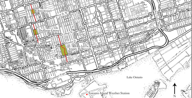
Map showing the four park sites and their respective bicycle transects (red line) as well as the Toronto Island weather station which was used for ambient weather conditions.
Download Hi-Res ImagePhoto: Graham Slater
Photo 1 of 12
 Close Me!
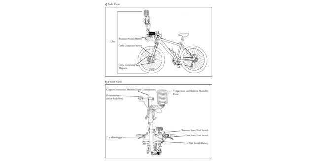
Top: Bicycle with quick release apparatus attached and instruments adjusted to 1.5m above ground level. Bottom: Front view of bicycle illustrating arrangement of instruments.
Download Hi-Res ImagePhoto: Graham Slater
Photo 2 of 12
 Close Me!
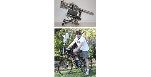
Top: Quick release apparatus collapsed into transport position. Bottom: Apparatus attached to bicycle showing scale and location, in relation to the cyclist.
Download Hi-Res ImagePhoto: Graham Slater
Photo 3 of 12
 Close Me!
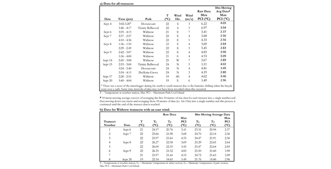
Top: The date and time of data collection for each part transect site as well as the ambient conditions and the maximum park cool island (PCI) recorded for each transect. Bottom: Data for Withrow Park transects with an east wind showing differences in temperature between urban and park environments for raw data and 10m moving averaged data.
Download Hi-Res ImagePhoto: Graham Slater
Photo 4 of 12
 Close Me!
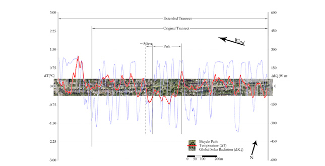
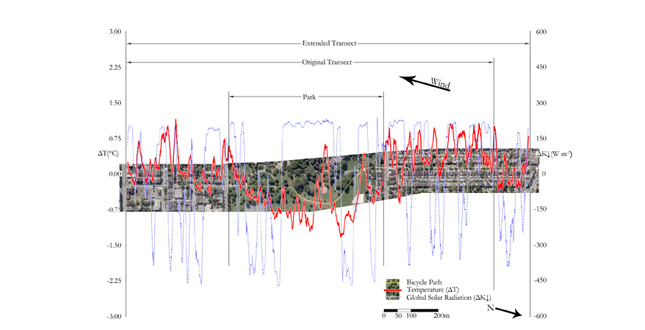
Withrow Park Combined transect showing park cool air extension of ~50m downwind of park. Graph consists of normalized, 10m moving average temperature and radiation data created by combining all transect passes from September 6, 7, 8, 9, and 20.
Download Hi-Res ImagePhoto: Graham Slater (Aerial Image: Bing Maps © 2009 Microsoft Corporation and © 2009 DigitalGlobe)
Photo 5 of 12
 Close Me!
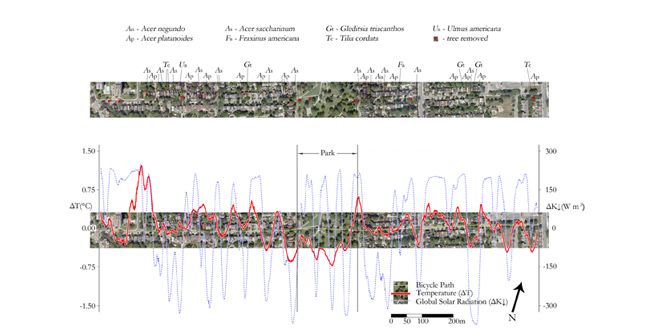
The cooling effect of street trees was more pronounced for mature silver maples (Acer saccharinum) than other mature trees suggesting that some trees species might be better than others at reducing air temperatures. Leaf Albedo and stomatal density could be possible explanations for these differences. (Aerial Image – Bing Maps © 2009 Microsoft Corporation and © 2009 DigitalGlobe).
Download Hi-Res ImagePhoto: Graham Slater (Aerial Image: Bing Maps © 2009 Microsoft Corporation and © 2009 DigitalGlobe)
Photo 6 of 12
 Close Me!
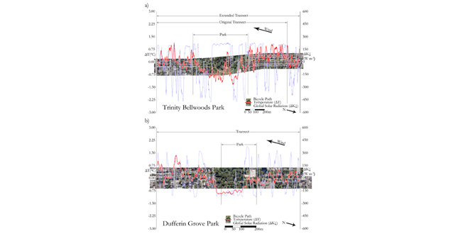
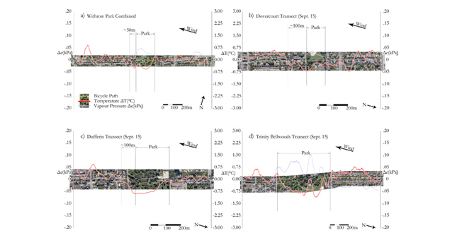
Normalized temperature and radiation data for Trinity Bellwood’s Park and Dufferin Grove Park transects on September 15 showing that a) open grass areas can be as warm as urban areas and b) treed park areas are cooler than open grass areas.
Download Hi-Res ImagePhoto: Graham Slater (Aerial Image: Bing Maps © 2009 Microsoft Corporation and © 2009 DigitalGlobe)
Photo 7 of 12
 Close Me!
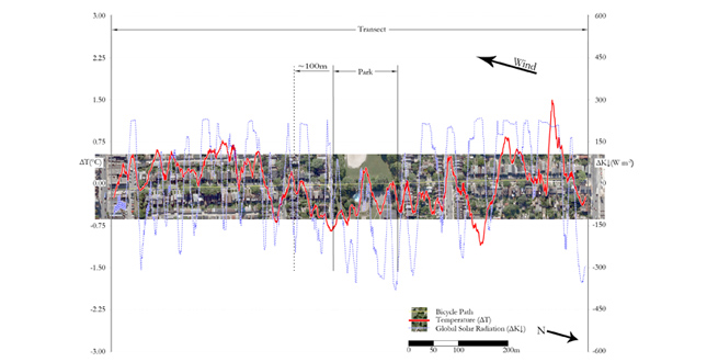
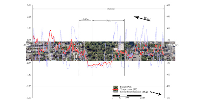
Dovercourt Park transect showing park cool air extension of ~ 100m downwind of park. Graph consists of normalized, 10m moving average temperature and radiation data for the transect completed on September 15.
Download Hi-Res ImagePhoto: Graham Slater (Aerial Image: Bing Maps © 2009 Microsoft Corporation and © 2009 DigitalGlobe)
Photo 8 of 12
 Close Me!
Dufferin Grove Park transect showing park cool air extension of ~ 100m downwind of park. Graph consists of normalized, 10m moving average temperature and radiation data for the transect completed on September 15.
Download Hi-Res ImagePhoto: Graham Slater (Aerial Image: Bing Maps © 2009 Microsoft Corporation and © 2009 DigitalGlobe)
Photo 9 of 12
 Close Me!
Trinity Bellwoods Park transect showing that busy streets at the edge of the park seem to negate park cool air extension. Graph consists of normalized, 10m moving average temperature and radiation data for the transect completed on September 15.
Download Hi-Res ImagePhoto: Graham Slater (Aerial Image: Bing Maps © 2009 Microsoft Corporation and © 2009 DigitalGlobe)
Photo 10 of 12
 Close Me!
Normalized 50m moving average temperature and vapor pressure data illustrating that vapour pressure increased and temperature decreased within the parks suggesting that park cool air was likely the result of increased evaporation/transpiration within the park.
Download Hi-Res ImagePhoto: Graham Slater (Aerial Image: Bing Maps © 2009 Microsoft Corporation and © 2009 DigitalGlobe)
Photo 11 of 12
 Close Me!
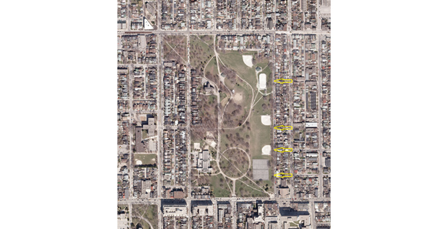
Extending streets on east side of Trinity Bellwoods Park one more block west (yellow arrows) would have opened the park to the prevailing summer winds and allowed greater park cool air extension.
Download Hi-Res ImagePhoto: Graham Slater (Aerial Photograph: Ontario Ministry of Natural Resources (2007)
Photo 12 of 12
Project Statement
This study investigated the potential of urban parks to mitigate the urban heat island effects of their surroundings. Results indicated that parks were up to 7°C cooler than their surrounding streets, and that park cooling, while variable, can extend almost 100m beyond a park’s boundaries. From this research, it is possible to generate design implications that can inform urban park and street design, creating cooler neighborhoods, increased human thermal comfort, and climate-sensitive design.
Project Narrative
With increasing world population and urbanization, the need for reducing urban temperatures and their related health consequences is becoming more critical. Could the cooler temperatures of urban parks and green spaces be a solution to rising urban temperatures? This study investigates the magnitude of urban park cooling and the potential of park cooling to mitigate the urban heat island effects of their surroundings.
Many cities around the world have already experienced rising air temperatures because of urbanization [1, 2]. This rising urban air temperature causes increased smog formation, which leads to an increase in poor air quality and heat related illness [3]. Furthermore, climatically diverse cities like Toronto experience more extreme heat related mortalities because people are less acclimated to the extreme temperatures experienced during heat waves [4]. Therefore, as urban development continues, the rising urban temperatures in Toronto (and other climatically diverse cities) will likely increase the population’s vulnerability to heat stress [4]. Additionally, the instances of summer heat waves are projected to increase in frequency, intensity, and duration in the future [5], increasing the importance of finding and implementing mitigation measures.
Method
This investigation focused on the city of Toronto, its dense urban structure likely similar to future urban growth in Canadian cities. Four park sites were selected that had a linear street-park-street orientation necessary for accurately assessing the park cool island intensity and cool air extension. A quick-release apparatus was designed and built to securely carry weather instruments on the front of a bicycle. The creation of the quick-release bicycle apparatus was essential to collecting continuous data on the magnitude of park cooling and its extent while allowing for quick completion of long transects. This accurate and precise data collection method addressed a limitation of previous studies by providing details on what happens between widely spaced transect points.
With instruments mounted to the front of a bicycle at 1.5m above ground level; air temperature, solar radiation, and humidity were measured along the four street-park-street linear transects. A complete transect consisted of two passes, one in each direction, completed at a speed of 9km/h, with a collection frequency corresponding to a 2m distance interval. Switches were used to mark the start and end of the transect and the start and end of the park within each transect.
Measurements took place in September on sunny days with minimal cloud cover, during a time period from 1:30-4:30pm because this coincided with the hottest part of the day and therefore the time of greatest park cooling [6].
Due to the weather conditions, Withrow Park was the only site with the same wind direction for multiple transects. All other sites consisted of single transects for a particular wind direction and although single transects can provide insight they are not capable of providing reliable results. Therefore, these results will focus on the eight Withrow Park transects with an east wind because the results are more robust.
Results
Maximum park cool islands (PCIs) were calculated by subtracting the minimum park temperature from the maximum urban temperature [7]. The maximum PCIs for all transects show that parks were always cooler than their urban surroundings.
Park cool island extension is the distance that cool air from a park extends beyond the park boundary. The data from the eight Withrow Transects was combined using a ten-metre moving average into a single transect, named Withrow Park Combined. The park cool island extension for the Withrow Park Combined transect was over 50m downwind from the park. Another important finding of this research was the ability of street trees to reduce the air temperature beneath them resulting in measurable cool patches along streets.
The most important findings of this research were that:
- parks were cooler than the surrounding urban environment by up to 7°C
- park cooling was variable but could extend almost 100m downwind into the neighborhood
- not all parks produced cool air extension
- busy streets appeared to inhibit cool air movement
- street trees could substantially reduce air temperatures underneath them
Conclusions
This research demonstrated that vegetation could inhibit the rising temperatures of the neighborhood during the day and that trees were the most valuable source of vegetation when it comes to cooling. This is because during the day they provide shade from the solar radiation as well as transpire vast amounts of water, making them capable of achieving substantial cooling effects [8]. This cooling value of trees was not just in the park environment but also along the tree-lined streets.
The cooling potential of tree-lined streets is likely greater than the cooling effects of parks because of the sheer number of streets that could be planted with trees. Therefore, the potential of street trees to intercept incoming solar radiation and prevent it from heating the air will likely have a greater effect on urban temperatures than the effects of urban park cooling on urban environments.
The following are the major design implications supported by this research:
- street trees could have a greater effect on urban air temperatures than parks due to the greater number of streets where they could be planted
- busy streets should be positioned away from the edges of parks and parallel to prevailing summer winds to allow cool air extension from parks
- create a network of smaller, interconnected, treed parks spread over the entire urban area, rather than a few large parks, to maximize the neighborhood contact with the cooler park environment
- different tree species have varying abilities to cool air and therefore tree selection could play an important role in park and street cooling potential
- open grass parks can be as warm as urban areas during the day making them uncomfortable places to be on hot sunny days
Urban parks and vegetation are valuable tools in creating comfortable outdoor spaces, but to take advantage of their climate modification, it is essential to know the intended use of the space, the prevailing climatic conditions of the city, as well as how different vegetation modifies the microclimate.
This research demonstrated that parks and street trees were capable of providing comfort to nearby residents in the form of cooler air temperatures. While parks were cooler than their urban surroundings, increasing street tree populations likely poses the greatest benefit to air quality and reducing heat related illnesses on hot summer days.
In conclusion, there is no denying the cooling effects of urban parks and trees. It is up to landscape architects, planners, and policy makers to create an environment that can foster the implementation of these benefits into all future development and renewal projects. Effectively utilizing these cooler environments through appropriate planning and design will be essential to reducing our vulnerability to heat related illnesses as global temperatures continue to rise, and urban populations continue to grow. This research generated design implications that can inform this urban design, creating cooler neighborhoods, increased human thermal comfort, and climate-sensitive design.
Future Research
Park cool islands are the greatest during hot weather [7] and therefore there is a need to conduct this study during the hottest summer days to determine if urban parks and street trees are capable of decreasing temperatures enough to reduce heat related illnesses. In addition, if park cool islands are larger in the summer, would they provide greater neighborhood relief by extending further downwind before equalizing with the urban air temperatures? There is also a need to determine whether there is an optimal amount, or configuration, of tree cover that can increase park cooling and cool air extension.
It is also hoped that with further research and the measurement of more variables (such as Normalized Difference Vegetation Index (NDVI), wind speed, and longwave radiation) a model could be produced that is able to predict air temperatures and cool air extension in complex street and park environments without the need for collecting extensive site data. Ultimately, the goal is to produce a model that consists of a small number of variables that are readily available to landscape architects, thereby allowing them to easily determine the thermal comfort and cooling potential of their designs.
References
- McPherson, E. G. (1994). Cooling urban heat islands with sustainable landscapes. In H. P. Rutherford, R. A. Rowntree & P. C. Muick (Eds.), The ecological city: preserving and restoring urban biodiversity. (pp. 151-171). Amherst: University of Massachusetts Press.
- Chang, C-R., Li, M-H., & Chang, S-D. (2007). A preliminary study on the local cool-island intensity of Taipei city parks. Landscape and Urban Planning, 80(4), 386-395.
- Akbari, H., Pomerantz, M., & Taha, H. (2001). Cool surfaces and shade trees to reduce energy use and improve air quality in urban areas. Solar Energy, 70(3), 295-310.
- Smoyer, K. E., Rainham, D. G. C., & Hewko, J. N. (2000). Heat-stress-related mortality in five cities in Southern Ontario: 1980–1996. International Journal of Biometeorology, 44(4), 190-197.
- Meehl, G. A., & Tebaldi, C. (2004). More Intense, More Frequent, and Longer Lasting Heat Waves in the 21st Century. Science, 305(5686), 994-997.
- Shashua-Bar, L., & Hoffman, M. E. (2000). Vegetation as a climatic component in the design of an urban street: An empirical model for predicting the cooling effect of urban green areas with trees. Energy and Buildings, 31(3), 221-235.
- Spronken-Smith, R. A. (1994). Energetics and cooling in urban parks. Unpublished Ph.D., University of British Columbia, Vancouver.
- Akbari, H., Davis, S., Dorsano, S., Huang, J., & Winnett, S. (1992). Cooling Our Communities: A Guidebook on Tree Planting and Light-Colored Surfacing: U.S. Environmental Protection Agency. Office of Policy Analysis. Climate Change Division.
Additional Project Credits
Research funding generously provided by the Natural Sciences and Engineering Research Council of Canada (NSERC) and the University of Guelph.