


Honor Award
The Jordan Valley’s New Border Reality
Fadi Masoud, Student ASLA, University of Toronto
Faculty Advisor: Liat Margolis
 Close Me!
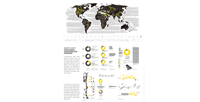
Water Shift Fresh Water Allocation and Diversion
Download Hi-Res ImagePhoto: Fadi Masoud
Photo 3 of 16
 Close Me!
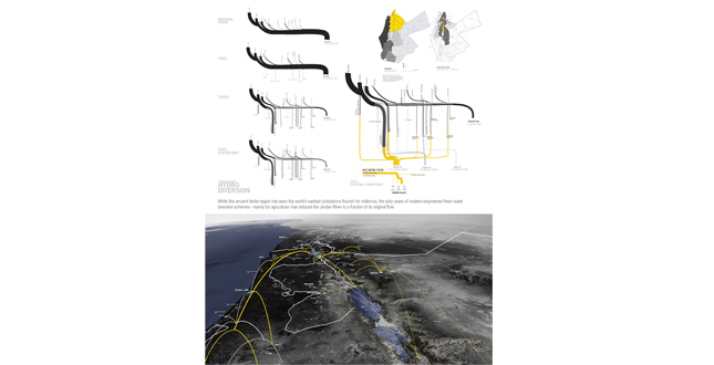
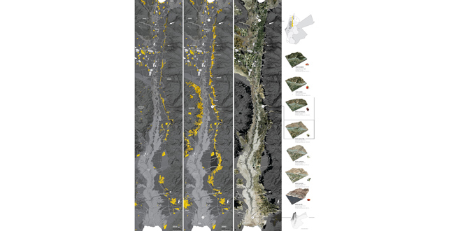
Jordan River Hydro Diversion. While this ancient fertile region has been the world’s earliest civilizations flourish for millennia, the sixty years of modern-engineered fresh water diversion schemes – mainly for agriculture- has reduced the Jordan River to a fraction of its original flow.
Download Hi-Res ImagePhoto: Fadi Masoud
Photo 4 of 16
 Close Me!
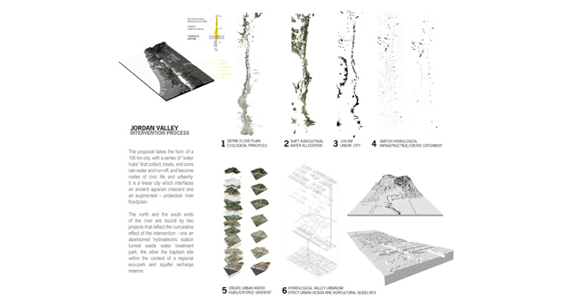
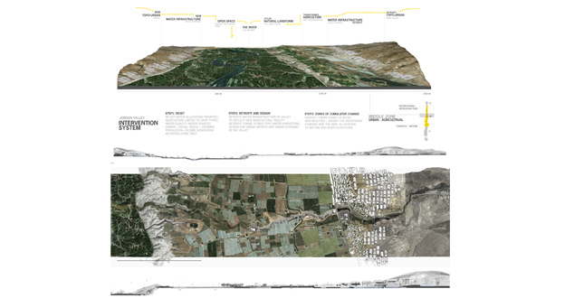
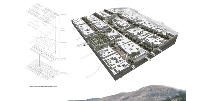
Top: Jordan Valley Intervention System. Below: Master Plan Hydrological — Agro-Urbanism Climate Gradient.
Download Hi-Res ImagePhoto: Fadi Masoud
Photo 6 of 16
 Close Me!
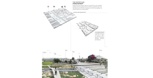
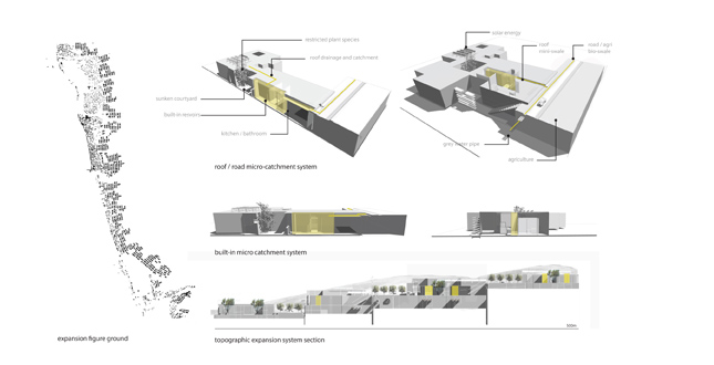
The Water Hub Hydro-Retrofit. Existing older towns along the valley are envisioned to be “hydro-retrofitted” buildings would be equipped with rain collectors, agricultural water channels become part of the urban landscape, and strict crop typologies are enforced based on the climatic gradient
Download Hi-Res ImagePhoto: Fadi Masoud
Photo 7 of 16
 Close Me!
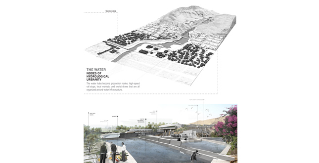
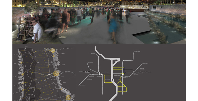
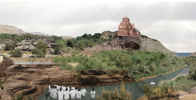
The Water Nodes of Hydrological Urbanity. The water hubs become production nodes, high-speed rail stops, local markets, and tourist draws that are all organized around water infrastructure.
Download Hi-Res ImagePhoto: Fadi Masoud
Photo 8 of 16
 Close Me!
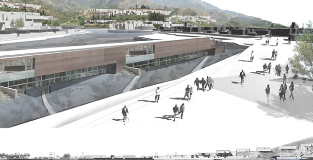
Water Hubs: Water Collection and Treatment as Civic Architecture — The section – plays an important role in development of the water infrastructure. The water hubs become production nodes, high-speed rail stops, local markets, and tourist draws that are all organized around water infrastructure.
Download Hi-Res ImagePhoto: Fadi Masoud
Photo 9 of 16
 Close Me!
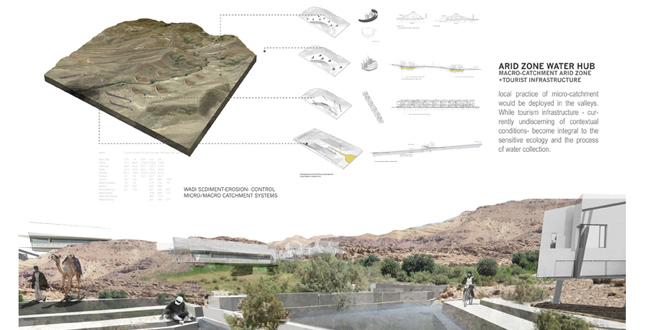
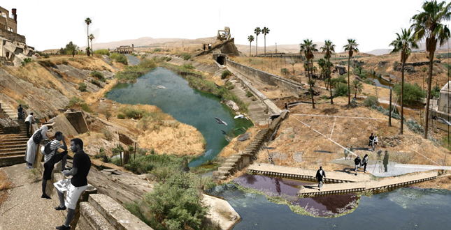
Arid Zone Water Hub: Macro-Catchment Arid Zone+Tourist Infrastructure — Local practice of micro-catchment would be deployed in the valleys. While tourism infrastructure — currently undiscerning of contextual conditions — become integral to the sensitive ecology and the process of water collection.
Download Hi-Res ImagePhoto: Fadi Masoud
Photo 10 of 16
 Close Me!
Hydrological Armature: An Armature for Valley Urbanism and Resource Resuscitation — each water hub is connected to a system decentralized system of water collection and treatment that center around the civic life of each node.
Download Hi-Res ImagePhoto: Fadi Masoud
Photo 11 of 16
 Close Me!
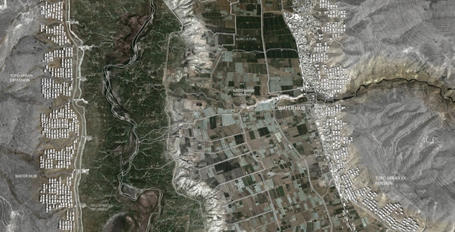
Topo-Urban Model for Expansion and Growth: This growth model sees that strict development guidelines for urban expansion is imposed in the valley. A contemporary urban typology that embeds itself in the topography to capitalize on hydrological flows while allowing appropriate agricultural practice to take place as well.
Download Hi-Res ImagePhoto: Fadi Masoud
Photo 13 of 16
Project Statement
This project will uncover the underplayed link between water-diversion for urbanization and agriculture and the resulting desertification in one of the world’s most disputed and symbolic border-river regions. It is a proposal for a regional landscape planning scheme that necessitates an understanding of the landscape’s limitations and potentials to create a new agro-urbanization regime for the Jordan Valley; One that is based on more receptive, de-engineered, and decentralized infrastructures involving trans-territories/border regions and organized around a new land use pattern.
Project Narrative
Using the Jordan River—as one of the world’s most contested and symbolic border-river regions as a case study—the project will uncover the underplayed link between water diversion for urbanization and agriculture and the resulting desertification, in this locale—and its global reach. In the Jordan River Basin, it has been proven that the most polemic and controversial aspect of water distribution is not scarcity but allocation and control. The premise for expedited change is that both agriculture and urban settlement along the Jordan River in their 20th century format will increase the contention in this already sensitive region if they do not evolve and adapt to new realities.
While this ancient fertile region has seen the world’s earliest civilizations flourish for millennia, the sixty years of modern-engineered fresh water diversion schemes has reduced the Jordan River to a fraction of its original flow. The resulting riparian environmental fallouts in an already ecologically sensitive region take a secondary role to the economic and political issues of the area. But as populations increase so does the demand for water, and all sides know that this impending issue cannot be overlooked. With prospects of the economy shifting away from the Valley’s water-intensive, non-lucrative agriculture, a new vision based on a regional landscape planning scheme and water infrastructure becomes necessary to ensure a stable future.
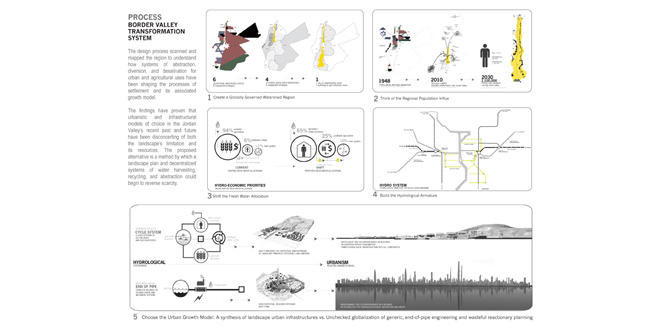
The design process scanned and mapped the region to understand how systems of abstraction, diversion, and desalination for urban and agricultural uses have been shaping the processes of settlement and its associated growth model. The findings have proven that urbanistic and infrastructural models of choice in the Jordan Valley’s recent past and future have been disconcerting of both the landscape’s limitation and its resources. The continuous investment and reliance on visions of end-of-pipe, energy intensive, and non-contextual growth models could prove to be short-sighted and potentially disastrous in this already sensitive region. The project’s conclusion will reveal how the future of the region rests on a new economy of fluids based on more receptive, de-engineered, and decentralized infrastructures involving trans-territories/border regions and organized around a new land use pattern.
The first step in this process was to attempt to unravel some of the geo-political considerations that have led to the decline of this region and to understand why the hundreds of policies and treaties have failed to ensure an equitable and healthy river region. The second was to collect information and data from the many actively engaged interest groups, such as Friends of the Earth Middle East, and the countless water engineers, scientists, and academics, who transcend political boundaries with visions of cooperation and believe that an augmented environmental river region could spell prosperity on all sides. The third step was to distill the data in a manner that allows for a physical intervention to be proposed as a vision for a sustainable and contextual growth model, appropriate agrarian landscape, and efficient built form.
Design becomes the agency and the tool that necessitates an understanding of the landscape’s restrictions and potentials; a method by which a landscape plan and decentralized systems of water harvesting, recycling, and abstraction could begin to reverse years of desertification and scarcity. It is also in this context where we could begin to offer contemporary alternatives by which we return to an understanding of regionally-appropriate methods of habitation and growth. In the case of the Jordan Valley it becomes a globally governed district of strict agricultural crop-cultivation, riparian ecological protection, and built-form/ urban design guidelines. This creates a co-habitation gradient that could manifest itself beyond its context to potentially neutralize geo-political contention.
The proposal takes the form of a 100 km city, with a series of “water hubs” that collect, treats, and store rain water and run-off, and become nodes of civic life and urbanity. The extreme climatic gradient - from temperate Mediterranean in the north to sub-Saharan near the lowest point on earth—offers these water hubs the potential to capitalize on this gradient to offer identity for each hub. It is a linear city which interfaces an ancient agrarian crescent and an augmented—protected- river floodplain that makes landscape, not politics, the new hegemon.
Additional Project Credits
Many thanks to Liat Margolis for her continuous guidance and dedication to the advancement of this project. Pierre Bélanger for his mentorship and constant, steadfast, and unwaviring advice over the past three years. To Baha Afaneh at Friends of the Earth Middle East, Lara Zureikat at CSBE and Engineers Abeer Nassar and Youssef Hassan at the Jordan Valley Authority for their insights and wealth of knowledge. To my family and to Matthew Brown and Martina Braunstein for their guidance and support. Drew Adams, Jameson Skaife, and Karen May for their valued opinions and assistance in the production of renderings and diagrams. Robert Wright for his unceasing devotion to the students during the thesis process and the field of Landscape Architecture.