


Honor Award
Orongo Station Conservation Master Plan
Poverty Bay, North Island, New Zealand
Nelson Byrd Woltz Landscape Architects, Charlottesville, VA USA
 Close Me!
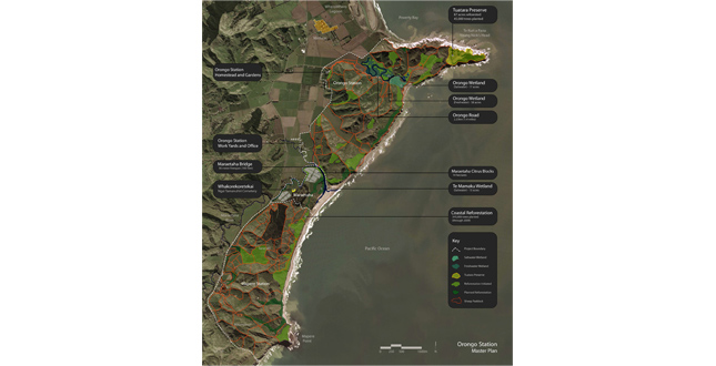
The master plan for Orongo Station (which includes Maraetaha and Mapere Station) encompasses 3,000 acres and weaves together multiple ecological restoration strategies with a working sheep farm and a rich cultural landscape.
Download Hi-Res ImagePhoto: Nelson Byrd Woltz Landscape Architects
Photo 1 of 16
 Close Me!
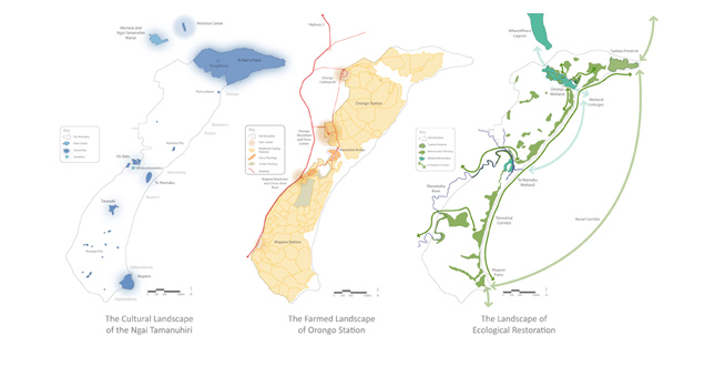
The master plan of Orongo Station simultaneously considers the cultural, agricultural, and ecological landscape. The constructed projects at the station are opportunities to create and reveal overlaps of these distinct landscape visions.
Download Hi-Res ImagePhoto: Nelson Byrd Woltz Landscape Architects
Photo 2 of 16
 Close Me!
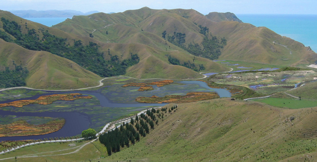
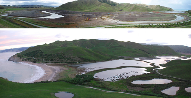
A closer view of the Teruri and Orongo Wetland illustrates the hybrid landscape of Orongo Station. This unique integration serves as a model for New Zealand farming operations and restoration efforts.
Download Hi-Res ImagePhoto: Nelson Byrd Woltz Landscape Architects
Photo 3 of 16
 Close Me!
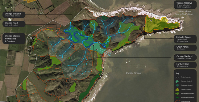
A closer view of the primary restoration projects at Orongo Station. The Tuatara Preserve has achieved unprecedented success in New Zealand in developing habitat and attracting targeted species. The Orongo Wetland project, still under way, is one of the most ambitious in the country.
Download Hi-Res ImagePhoto: Nelson Byrd Woltz Landscape Architects
Photo 4 of 16
 Close Me!
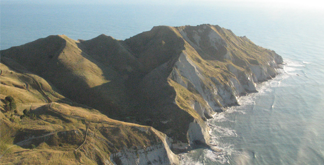
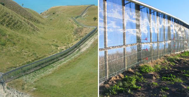
The promontory of Young Nick’s Head. The Excluder Fence isolates the promontory from predators to create the 87-acre Tuatara Preserve. An audio speaker system attracts the grey-faced Petrel to nest and breed the first success of its kind in the world.
Download Hi-Res ImagePhoto: Nelson Byrd Woltz Landscape Architects
Photo 5 of 16
 Close Me!
The 1,640-foot-long Excluder Fence includes a flange at the top to discourage climbing rodents. A below-grade flange repels any attempt to dig under the barrier.
Download Hi-Res ImagePhoto: Nelson Byrd Woltz Landscape Architects
Photo 6 of 16
 Close Me!
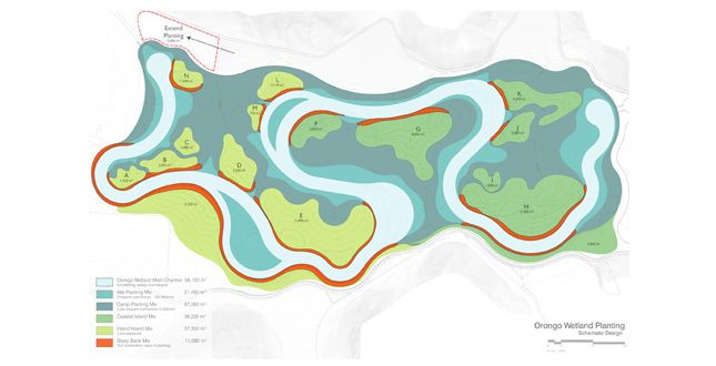
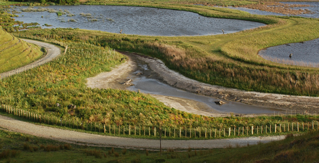
The planning of the wetland included careful arrangement and sizing of the islands to provide particular habitat for birds and amphibians. The steep banks help provide protection from predators during critical nesting periods.
Download Hi-Res ImagePhoto: Nelson Byrd Woltz Landscape Architects
Photo 7 of 16
 Close Me!
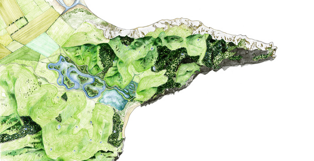
This conceptual rendering of the completed wetland helps illustrate the scale of the construction and the future wildlife corridors created by the reforested valleys.
Download Hi-Res ImagePhoto: Nelson Byrd Woltz Landscape Architects
Photo 8 of 16
 Close Me!
Photos of the wetland under construction show both the sinuous channel that retains water throughout the year and the flooded condition during the wet season.
Download Hi-Res ImagePhoto: Nelson Byrd Woltz Landscape Architects
Photo 9 of 16
 Close Me!
The 1,890-foot-long earthen dam separates the freshwater from the saltwater wetland. It also provides a mown walking path through the wetland environment.
Download Hi-Res ImagePhoto: Nelson Byrd Woltz Landscape Architects
Photo 10 of 16
 Close Me!
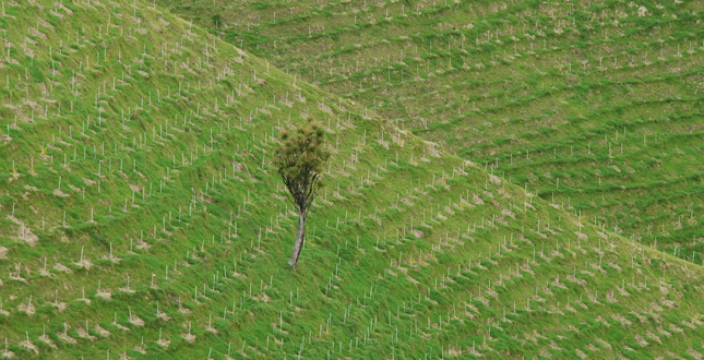
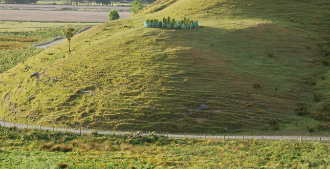
A typical Orongo Station reforestation planting. Planters brace the steep slopes to drill, spot spray, and plant the reforestation-grade seedlings. Each stake represents a single plant that will quickly provide cover for the next stage of succession.
Download Hi-Res ImagePhoto: Nelson Byrd Woltz Landscape Architects
Photo 11 of 16
 Close Me!
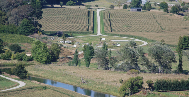
The master plan realigned roads and organized agricultural fields to celebrate an existing Maori cemetery and sacred ground in the middle of the image. A new entrance garden, wood carved gate, and planting of the site will be completed in 2011.
Download Hi-Res ImagePhoto: Nelson Byrd Woltz Landscape Architects
Photo 12 of 16
 Close Me!
One of the circular plantings around the ceremonial burial of a newborn’s umbilical cord. For the Maori this place becomes important as the spot where one symbolically emerges into the world.
Download Hi-Res ImagePhoto: Nelson Byrd Woltz Landscape Architects
Photo 13 of 16
 Close Me!
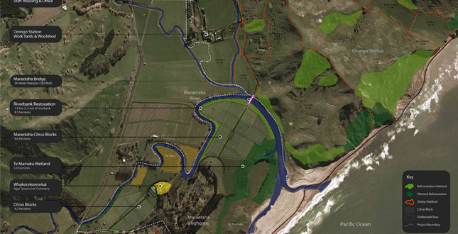
Master plan of the Maraetaha River floodplain incorporating ecological restoration, the cultural landscape, and working farm components.
Download Hi-Res ImagePhoto: Nelson Byrd Woltz Landscape Architects
Photo 14 of 16
 Close Me!
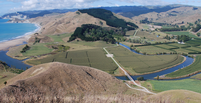
The redesign of the Maraetaha River floodplain included the design and placement of a bridge, layout of the farm road and work yards, and the establishment of the agricultural patterns. By collaborating with farms, a relationship to the broader landscape was accomplished.
Download Hi-Res ImagePhoto: Nelson Byrd Woltz Landscape Architects
Photo 15 of 16
 Close Me!
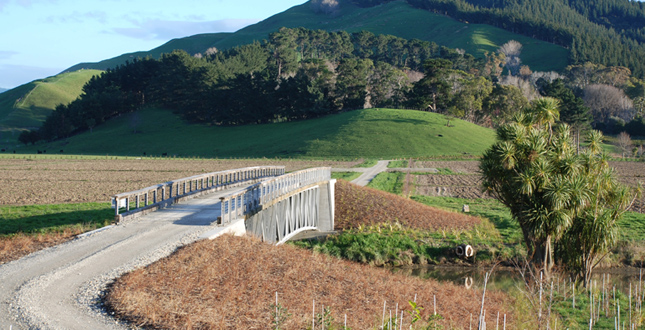
The bridge across the Maraetaha River was designed to keep a low profile while striking a powerful line across the floodplain toward the sacred hill of Taranaki. The steel-trussed bridge has a wood deck and handrails of recycled timber.
Download Hi-Res ImagePhoto: Nelson Byrd Woltz Landscape Architects
Photo 16 of 16
Project Statement
The Orongo Station Conservation Master Plan for a 3,000-acre sheep farm in New Zealand establishes a vision for the extensive regeneration of a devastated ecology while expanding agricultural production and revealing a cultural landscape rich in history. Completed in collaboration with a team of public officials, private stakeholders and local experts, the project serves as an important model that can expand the current definitions of sustainability and landscape architecture.
Project Narrative
—2010 Professional Awards Jury
In 2003, Orongo Station was a typical sheep farm on the East Coast of New Zealand's North Island. Grazing sheep and livestock was tough due to the brutal salt spray and erosion on the exposed slopes. The station's only notoriety came from the prominent cliffs on its northern peninsula—Te Kuri a Paoa, also called Young Nick's Head. This promontory is important to the history of New Zealand both as the landing site of the Horouta Canoe, bringing Maori to the island, and as the first land spotted by Captain Cook's crew, the first whites to visit the island in 1769.
The ecology of Orongo Station, like that of much of New Zealand, has been under assault ever since the arrival of mankind in the 13th century. Lush, temperate rain forest covered the North Island and teemed with a rich diversity of birds, amphibians, and invertebrates. Early Maori settlers cut much of the forest for fire, shelter, and agriculture. The later arrival of English colonists brought further destruction of the forests for lumber and grazing while introducing mice, cats, weasels, rabbits, and other alien mammals that quickly decimated native bird and amphibian populations.
Assisted by a talented team of biologists and ecologists, the team saw a unique opportunity for a major wildlife conservation area on the peninsula of Young Nick's Head. Protected by steep cliffs on three sides, the landscape architect orchestrated the installation of a predator-proof fence to create a sanctuary ideal for nesting migratory birds. Existing rodents and pests were eradicated and a dense planting of coastal woodland tree saplings were planted to create habitat. The ultimate goal for the sanctuary is to re-introduce the Tuatara, a highly endangered prehistoric reptile that once inhabited the exposed cliffs of the North Island. The effectiveness of the restoration efforts are supported by a vigilant and aggressive pest control regime. The improved habitat and reduced predation has already attracted new arrivals and nesting including blue penguins, and fluttering shearwaters. An audio system that plays recorded bird calls has attracted the endangered grey-faced petrel to nest and breed, the first success of its kind in the world.
To support the efforts of the Tuatara Preserve, the landscape architect initiated an extensive plan for restoring the adjacent Orongo wetland, a once-vibrant tidal wetland that previous landowners drained for grazing. To provide a diversity of habitat, the master plan proposed the restoration of a saltwater wetland and the construction of a freshwater wetland. A large sinuous earthen embankment divides the watersheds and diverts rainwater to the inland freshwater wetland. While the saltwater wetland is tidal, the freshwater wetland is designed to accommodate seasonal flooding. A winding ribbon of water flows year-round and the broad flats flood during the wet season. To create and maintain habitat throughout the year, islands were designed and shaped from fill created by excavation of the channel. The islands' slopes and sizes are carefully calibrated to provide protective habitat for specific amphibians.
Reforestation on the uplands above the wetlands is part of a larger effort that extends southward from the Tuatara Preserve five and one half miles along the coast. These highlands are exposed to battering winds and rain and are slowly eroding into the sea. Reforestation helps stabilize the vulnerable coastline while creating valuable habitat and increased connectivity through wildlife corridors. To date, 500,000 trees have been planted at Orongo Station.
The land of Orongo Station is sacred to the local Maori tribe—the Ngai Tamanuhiri. Remnants of earthen defensive structures, fishing encampments, and pits created to store the staple food crop (the Kumara) are found throughout the landscape. The master plan engaged the tribe to restore a cemetery on the property which suffered from poor access and neglect. Simple design strategies raise the prominence of the cemetery in the river valley and protect adjacent historic defensive structures. These efforts have fostered a positive relationship with the tribe and create a regional model for integrating agricultural practices with the restoration of Maori cultural landscapes. Moreover, the ecological restoration projects are a source of pride for the tribe. The design team worked with the Ngai Tamanuhiri to start a nursery that allows the tribe to supply some of the trees required for the reforestation effort. This provides much needed employment and invites the community to share their wisdom of local plants and participate in the ecological regeneration.
The efforts to celebrate the Maori cultural landscape and to restore ecologies and habitat for endangered species are unique in their integration with an active, working, and profitable agricultural operation. In their search for more balanced farming practices, the designers sought methods to integrate these efforts while designing some of the primary functional pieces of the farming operation. The architecture of the farm, the shearing sheds, vehicle and equipment storage, and staff housing have been composed to create a multifunctional courtyard. A bridge and road over the Maraetaha River were designed by the entrant not only to provide improved farm connectivity but to compose the river floodplain in a way that celebrates the surrounding physical and cultural landscapes. The road and bridge strike a straight line across the floodplain to align with the peak of the enormous hill of Taranaki beyond, a site of sacred significance to the Maori. Also, the designers collaborated with farmers to lay out the flat's citrus fields and inscribed a sweeping arc of shelterbelt trees to mark its outer boundary. A journey across the field pierces the broad arc which parallels the natural course of the river and serves as the site for a major riverbank restoration planting. The bridge design keeps a low, elegant profile to respect views from adjacent properties and roads.
Finally, the efforts to knit ecology, farming, and the cultural landscape together have been distilled into a series of gardens and buildings at the residence of Orongo Station's owners and their family. The complex is anchored by a historic house, the Homestead. The gardens and buildings create formal and informal spaces for entertaining, for play, and discovery. They are rich in narrative, using plants and earthworks to tell important stories about New Zealand ecology and culture. The gardens look back through the island's environmental history, distilling the primary forces at work, and recomposing them in a contemporary language. The gardens create a lens for visitors to understand the efforts of the nationally important conservation efforts on Orongo Station and the new vision that they represent.
Project Resources
Nelson Byrd Woltz Landscape Architects
Thomas L. Woltz, ASLA, Partner in Charge
Breck Gastinger, Senior Project Manager
Contributing Staff: Hara Woltz, Sara Myhre, Evan Grimm, Jim Kovach, Jeff Aten, ASLA, David Timmerman, Karl Krause, Student ASLA
Orongo Station
Kim Dodgshun, General Manager