

«previous pageANALYSIS & PLANNING CATEGORY
OKRail 2025: Reclaiming Rural America
Cody Klein, Student ASLA, and Seth Slifer, Student ASLA
Oklahoma State University, Stillwater, OK
faculty advisor: John R. Ritter, ASLA
Project Statement
Because of the convenience and affordability of automobile transportation, abundance of cheap fuel supply, and available land use, an ever-growing problem of urban and suburban sprawl have created a negative growth pattern in Oklahoma and across the nation. This project focuses on initiatives to create a more environmentally friendly transportation model including pedestrian-friendly neighborhoods, alternative methods of mass transportation focusing on passenger rail, and connecting major metropolitan areas devoid of the automobile.
Project Narrative
Due to the ongoing effects of urban and suburban sprawl, especially within the Midwestern United States, communities have become disconnected not only physically and geographically, but also socially. This problem stems back to the post-WWII, auto-centric way of thinking. The automobile has been a catalyst of "independence" and a way of attaining the American Dream. Bearing in mind the current state of the economy and the negative effects of this auto-centric society, we must consider alternative means of transportation to reduce our dependence on foreign oil and the automobile. This will ultimately create more pedestrian-friendly neighborhoods and bolster new ways of viewing transportation in the Mid-west.
This project focuses on creating a regional transportation system based upon multi-modal means of transportation including passenger rail, bus, bicycle, and foot traffic. Presently, Oklahoman's primary means of travel is the automobile, due to the lack of efficient public transportation systems and the proximity of housing options relative to employment and obtaining goods and services essential to human survival.
A fixed guide way study conducted in 1993 showed conclusively that light commuter rail would be the most effective mode of mass transit for the state of Oklahoma in the future. Considering that the State of Oklahoma currently owns over 900 miles of railway and is utilizing a mere fraction, this untapped resource appears obvious when considering alternative means of transportation. In addition, Oklahoma 's road construction projects in the past 30 years haven't been in the least bit profitable or effective. For example, since 1984, the State of Oklahoma has spent over 108 million dollars on a campaign to widen Interstate 35 to accommodate vehicular traffic. Since Construction began 25 years ago, only 20 miles of progress has been made. The Oklahoma Department of Transportation has issued statements claiming that they "cannot pour concrete fast enough to keep up with growth".
Is There a Solution?
By utilizing the existing rail infrastructure owned by the State of Oklahoma, this project intends to create a regional railway system that is not only cost-effective, but also environmentally friendly, and encourages alternative means of transportation on a local and regional level. At present, the only rail line being utilized for passenger travel in the State of Oklahoma is the "Heartland Flyer", an AmTrak line that runs from Oklahoma City to Ft. Worth, Texas.
Due to the rural nature of this region in America, options for means of transportation alternative to the automobile are inherently limited. OKrail2025 is an initiative to implement passenger rail throughout Oklahoma that not only connects the metropolitan areas of Tulsa and Oklahoma City to the surrounding region, but also connects small towns such as the City of Chandler (a model town showcased in this project) to the rest of the state.
Analysis and Data Collection
Through Geographic Information Systems analysis, census studies, alternative transportation methods analysis, research of previously conducted transportation studies in the State of Oklahoma, and watershed and topographic investigation, methods of solving Oklahoma's transportation dilemma were deduced. Due to the vast amount of rail lines presently owned by the state and the lack of geographic and topographic limitations, the results of the analysis conclusively proved that light passenger rail was to be the most effective means to solve the issue on a regional scale.
On a more local scale, the same means of data analysis and collection were used to select a "model city" to showcase how such an alternative transportation plan could be successfully implemented as well as beneficial. Considering its proximity to major metropolitan areas such as Tulsa and Oklahoma City, availability of existing rail infrastructure, geographic and topographic assets, and declination of local commerce, the City of Chandler, OK was selected as a prime candidate for the implementation of a transit-oriented infill development.
A City Divided/A City Connected
Located geographically between the two metropolitan areas in Oklahoma (Tulsa and Oklahoma City), and containing significant infrastructural, topographical, historical, and cultural features, Chandler was selected as a "model city" for the OKrail2025 initiative. Extensive analysis proved that the City of Chandler could benefit greatly from the realization of a transit-oriented infill development. An existing freight rail line bisects the two core areas of development in the town creating a significant disconnect physically, visually, and even demographically. This project proposes utilization of this existing rail, retro-fitted with a third rail system to reduce infrastructure cost and the use of fuel, as the primary means of transportation into and out of Chandler. This rail line connects directly to Oklahoma City to the West and Tulsa to the East, servicing rural areas between the two such as Chandler , Bristow, and Sapulpa. This type of existing infrastructure presents an enormous opportunity in terms of revitalizing dilapidated town centers and less-than-ideal economic conditions in rural Oklahoma through the implementation of transit-oriented infill developments. This project's vision is to reconnect rural Oklahoma to the major metropolitan areas in the state and ultimately the rest of the nation devoid of the automobile.
Chandler and its downtown evolved greatly due to the construction of Route 66 which also bisects the town. Although symbolically this somewhat detracts from the initiative at hand due to its implication of the significance and celebration of the automobile, it carries with it a strong cultural and historical richness which cannot be ignored and instead should be commemorated. The underlying theme of the proposed infill development in Chandler focuses on remembering the past and realizing the future.
Some of the main site constraints in Chandler include, but are not limited to: a lack of identity and sense of place; segmented infrastructure; fragmented ecosystems; and deficient access/connectivity. Thus, the work program for the development of the "model city" is as follows: Create an unmistakable identity and sense of place in the City of Chandler through historic downtown and street revitalization, architectural vernacular, and construction of the 9th Street Promenade and iconic multi-modal transportation hub; "Bridge the gap" between the two core areas of development not only physically, but also symbolically; Connect the existing fragmented ecosystems by means of the Plant 100,000 Trees Initiative creating a healthy and sustainable ecosystem; and enhance the site's ingress and egress while promoting alternative means of transportation through site features such as park and ride facilities, bicycle lanes, walking and biking trails, and sufficient public transit.
The 9th Street Promenade and multi-modal transit hub are to serve as iconic structures for sustainability and green infrastructure. Bridging the gap between the eastern and western portions of Chandler, the 9th Street Promenade is an elevated boulevard with bike lanes, prominent sidewalks, mixed-use zoning, and locale for the multi-modal transit hub. This viaduct creates a safe and substantial crossing of the rail corridor while enhancing the aesthetic appeal of Chandler. The multi-modal transit hub will serve as a model for green building and infrastructure with intent to reach LEED Certification through the execution of green building features. The roof of the transit hub will be an extensive roof garden for demonstration of green technologies such as solar and wind harvesting, rainwater collection and storage for irrigation purposes, and live roof plant species.
Another design feature to be implemented in Chandler is a multi-level mixed-use district reviving the derelict housing conditions of Dewey Avenue on the East side of the rail corridor. This will create ample square footage for incoming businesses and increase commerce in the city ultimately transforming Chandler into a destination city. This district will promote alternative means of transportation by including narrow streets, bicycle lanes, interior/hidden parking, wide sidewalks, and bioretention cells to 'green'/beautify the streets and collect and retain storm water runoff making them exceedingly pedestrian-friendly. This will not only serve as a means to reduce dependence on the automobile and oil, but also to promote a healthy lifestyle by encouraging physical activity.
The City of Chandler will serve as an inspiration for rural areas in Oklahoma and across the nation. Proving that innovation and vision can revitalize small towns to their once prosperous condition without sacrificing the sense of pride in community that so many share.
Additional Project Credits
Alejandro Rivero Herrera, ASLA
Adjunct Professor
Oklahoma State University
Landscape Architecture Program
Mark Gregory
Assistant Researcher
Oklahoma State University
GIS Applications
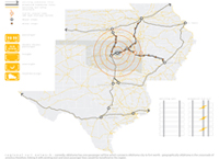
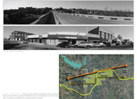
Regional Rail Network: currently, Oklahoma has one passenger rail line which connects Oklahoma City to Fort Work, geographically Oklahoma is the crossroads of America; therefore, linking it with existing east and west passenger lines would be beneficial to the region.
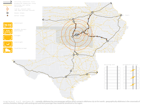
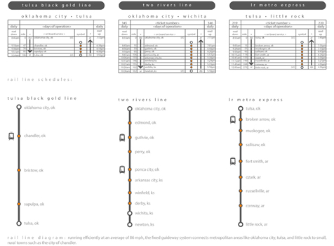
Rail Line Diagram: running efficiently at an average of 86 mph, the fixed guideway system connects metropolitan areas like Oklahoma City, Tulsa, and Little Rock to small, rural towns such as the City of Chandler.
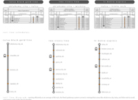
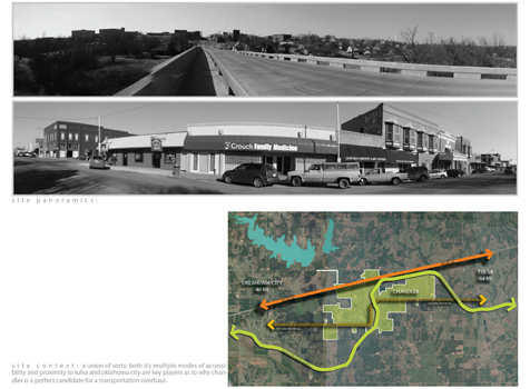
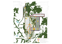
Site Context: A union of sorts; both its multiple modes of accessibility proximity to Tulsa and Oklahoma City are key players as to why Chandler is a perfect candidate for a transportation overhaul.
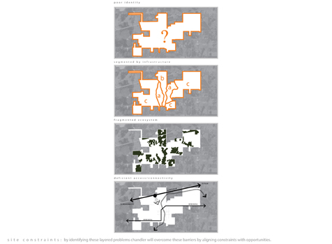
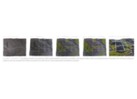
Site Constraints: by identifying these layered problems Chandler will overcome these barriers by aligning constraints with opportunities.
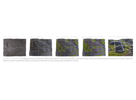
Study Model: providing a hands-on experience while examining the constraints, amenities, and opportunities of the core development in Chandler, the working model provided us with the needed information to develop our infill site in a more appropriate and efficient manner.
"Pretty sophisticated move for undergraduates to pick a small town and do a study. Very nice drawings. Well done!"
— 2009 Student Awards Jury
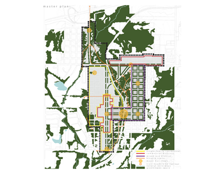
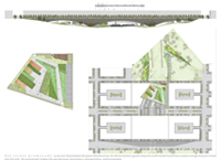
Master Plan
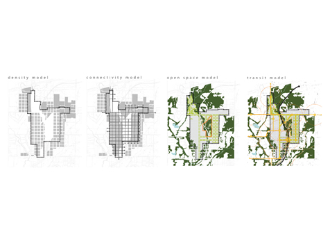
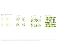
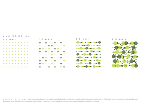
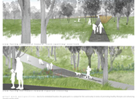
Ecology Strategy: mixing densely planted tree saplings can be later thinned and transplanted elsewhere across the site to effectively grow a complex multi-aged woodland over time. Restoration is most successful when a mixture of early-successional and later-successional tree species is planted.
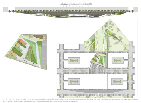
9th Street Promenade: as an icon of promotion for green infrastructure, the demonstration garden atop the multi-modal transit hub sustains energy and puts it back into the grid. The promenade bridges the gap between generations, transportation, and topography.
Great Park Perspectives: due to its centralized location, the great park is a catalyst for the community in terms of promoting healthy lifestyles and enhancing peoples quality of life.
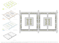
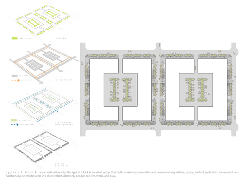
Typical Block: as a destination city, the typical block is an ideal setup that both maximizes amenities and conservatively utilizes space, so that pedestrian movement can functionally be emphasized in a district that ultimately people can live, work, and play.

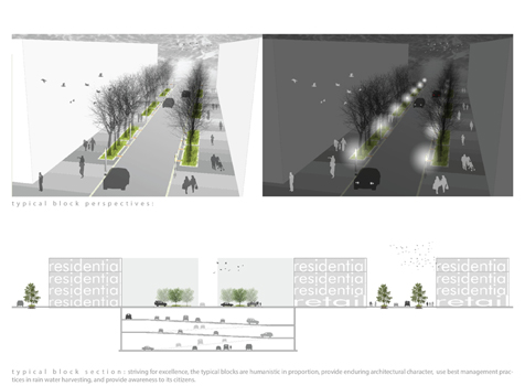
Typical Block Section: striving for excellence, the typical blocks are humanistic in proportion, provide enduring architectural character, use best management practices in rain water harvesting, and provide awareness to its citizens.