

«previous pageANALYSIS & PLANNING CATEGORY
MUMBAI: Infrastructure as Architecture
University of Pennsylvania, Philadelphia, PA
faculty advisor: Anuradha Mathur
Project Statement
Optimizing infrastructure as an urban resource, each component of the proposed water capture system is also a civic space and is strategically located along the existing network of streets, paths and plazas that run between the abandoned quarry and the wetlands. These new urban spaces connect fragmented parts of the existing path network and serve a host of civic, recreational, commercial and social functions while supplying domestic and commercial water for 25,000 people.
Project Narrative
Studio Mumbai: The Edge of the Forest
The western edge of the Sanjay National Forest intersects the city of Mumbai, creating one of the largest natural preserves in the world within a major urban area. The opportunities presented by this intersection of wilderness and urbanization intrigued me and so I selected it as a studio project.
Our first task was to select a terrain along this boundary and analyze it using google earth, historical maps and written texts. Followed by a 10 day site visit and a series of lectures and reviews with guest critics, we were asked to situate a design proposal within our chosen terrain.
Given the extreme social and environmental conditions in Mumbai: a city of incredible poverty, thick traffic and air pollution and little or no infrastructure; my challenge was to leverage the edge of the forest by pairing opportunities for preservation and conservation with increased accessibility and social support, to be implemented with under-utilized and un-exploited resources.
The mandate, as I saw it, was to develop a scheme that would support and strengthen local communities, better serve the city-wide population as a major public park and nature preserve, and extend the potential of the national forest management team as stewards of an integrated series of ecological processes currently severed by the existing park boundaries and the limits of its mission.
To serve these civic, social and environmental objectives, I selected the northern-most terrain of the park where the forest edge is closest to the creek system and shrinking mangrove areas of the estuary. Here a mosaic of high-end residential towers interspersed with tarp-roofed villages and informal settlements occupy the terrain between the forest and the sea. The National Forest lands have been quarried extensively for basalt, and the confluence of two watersheds flows directly through the abandoned quarry to the edge of highway.
The Objectives of My Proposal
- To develop a cooperative relationship between new and existing settlements, instead of displacing one for the other, and in turn, to develop a cooperative configuration of new settlements within existing and new wetlands systems, providing an alternative to the current trend of consuming wetland areas with new development.
- To provide basic social services for local residents who currently have no public or private toilets, domestic water or other basic washing facilities.
- To leverage the quarry's position within the watershed to capture and direct monsoon rains for domestic, aquacultural, agricultural and ecological uses.
- To broaden the ecological work of the National Forest by extending its range to the mangroves, connecting them physically and as custodians of Mumbai's fragile wetlands assets.
- To create a recreation area for the National Forest that embraces the history of the landscape and reoccupies the quarried terrain in a new way.
Optimizing Water Systems
My proposal outlines a scheme to optimize the resource of the monsoon rains with the lowest volume of construction, and maximize the utility of the water before releasing it to the mangroves.
Intertwining infrastructure and civic space provides an explicit system of public access and stewardship to support social, ecological and environmental connectivity. The system allows the urban environment to adapt to the wet/dry season, making the most of each season and maximizing water by taking full advantage of the terrain as the seasons change.
Each component of the water-capture system serves a role as a civic space and is strategically located along the existing streets, paths and plazas that run between the abandoned quarry and the wetlands. These new urban spaces connect fragmented parts of the path network and serve a host of civic, recreational, commercial and social functions.
This system accommodates the seasons and encourages sequent occupation of the landscape as water volumes ebb and flow. It is designed to reflect and articulate these changes, that they be better understood and appreciated, as the rising and lowering waters reveal and conceal their nature.
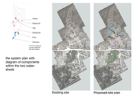
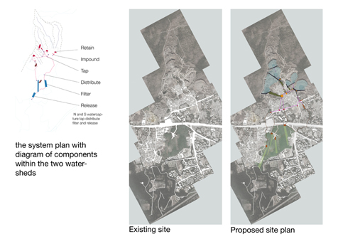
The system plan with diagram of components within the two watersheds.
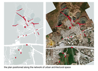
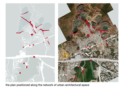
The plan positioned along the network of urban architectural space.
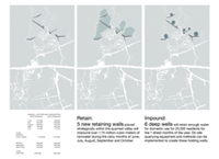
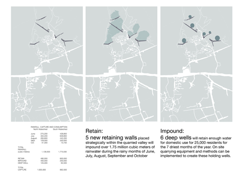
Left: Rainfall Capture and consumption. Middle: Retain: 5 new retaining walls paced strategically within the quarried valley will impounded over 1.75 million cubic meters of rainwater during the rainy months of June, July, August, September and October. Right: 6 deep wells will retain enough water for domestic use for 25,000 residents for the 7 driest moths of the year. On site quarrying equipment and methods can be implemented to create these holding wells.
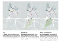
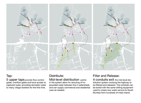
Left: Tap: 5 upper taps provide flow control gates, overflow gates and local access to captured water, providing domestic water to many village dwellers for the first time. Middle: Distribute: Mid-level distribution points in the system allow for rerouting of impounded water between the 2 watersheds and can supply commercial and residential uses as needed. Right: Filter and Release 4 conduits exit the mid-level distribution system crossing the highway to be filtered and released. The conduits can be bored with the same drilling equipment used to create new water service to South Mumbai from hundred of miles inland.
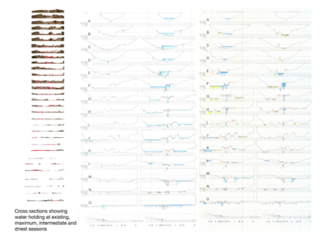
Cross sections showing water holding at existing, maximum, intermediate and driest seasons.
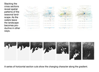
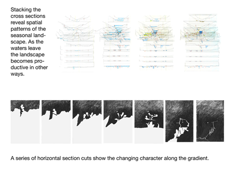
Stacking the cross sections reveal spatial patterns for the seasonal landscape. As the waters leave the landscape becomes productive in other ways. A series of horizontal section cuts show the changing character along the gradient.
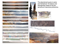
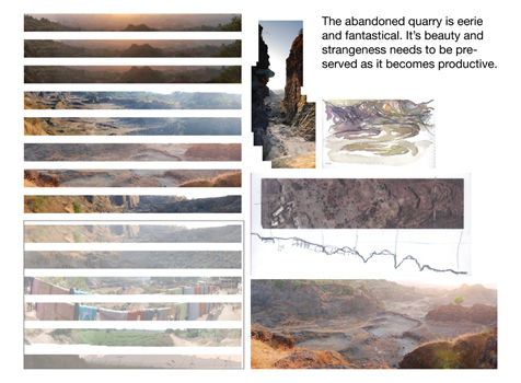
The abandoned quarry is eerie and fantastical. Its beauty and strangeness needs to be preserved as it becomes productive.
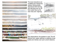
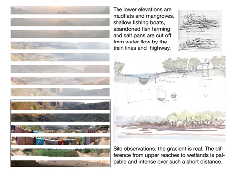
The lower elevations are mudflats and mangroves. Shallow fishing boats, abandoned fish farming and salt pans are cut off from water flow by the train lines and highway. Site observations: the gradient is real The difference from upper reaches to wetlands is palpable and intense over such a short distance.
"Fantastic hand graphics, especially the water system section. Very well done."
— 2009 Student Awards Jury
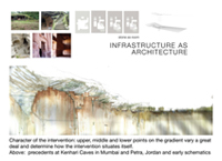
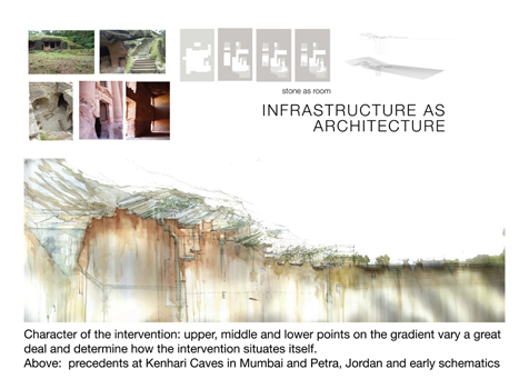
Character of the intervention: upper, middle and lower points on the gradient vary a great deal and determine how the intervention situates itself. Above: precedents at Kenhari Caves in Mumbai and Petra, Jordan and early schematics. (Two Top Left Images: Anuradha Mathur)

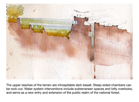
The upper reaches of the terrain are inhospitable dark basalt. Steep-sided chambers can be rock-cut. Water system interventions include subterranean spaces and lofty overlooks, and serve as a new entry and extension of the public realm of the national forest.
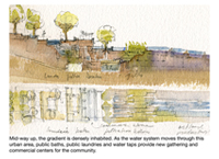
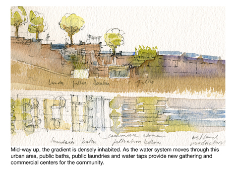
Mid-way up, the gradient is densely inhabited. As the water system moves through this urban area, public baths, public laundries and water taps provide new gathering and commercial centers for the community.
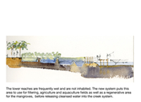
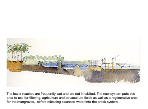
The lower reaches are frequently wet and are not inhabited. The new system puts this area to use for filtering, agriculture and aquaculture fields as well as a regenerative area for the mangroves, before releasing cleansed water into the creek system.

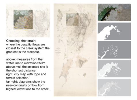
Choosing the terrain: where the basaltic flows are closest to the creek system the gradient is the steepest. Above: measures from the water line to elevation 250m above msl. The selected site is the shortest distance. Right: city map with topo and terrain selection. Far right: diagrams show the near-continuity of flow from highest elevations to the creek.
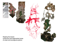
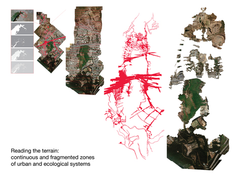
Reading the terrain: continuous and fragmented zones of urban and ecological system.
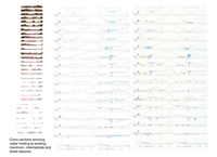
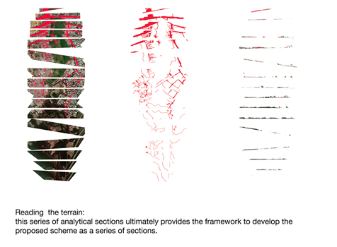
Reading the terrain: this series of analytical sections ultimately provides the framework to develop the proposed scheme as a series of sections.
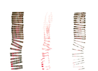
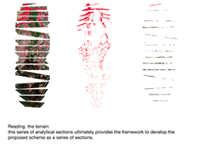
Reading the terrain: this series of analytical sections ultimately provides the framework to develop the proposed scheme as a series of sections.