

«previous pageGENERAL DESIGN CATEGORY
Honor Award
The Dell at the University of Virginia, Charlottsville, VA
Nelson Byrd Woltz Landscape Architects, Charlottesville, VA
client: The University of Virginia
Project Statement
The Dell is an 11-acre hybrid landscape that resurrects a buried stream at the University of Virginia, transforming derelict and unused land into a state-of-the-art stormwater pond and forebay system. The park reintroduces vanishing wildlife habitat, provides multiple recreation opportunities while mediating between campus and an adjacent neighborhood, serves as a memorable entrance for visitors arriving at the University, and functions as a demonstration landscape and Virginia-native ecobotanic garden for students and faculty.
Project Narrative
The Dell is a significant cultural, social, and ecological site on the grounds of the University of Virginia (UVA). It is a place of activity — basketball, tennis, informal Frisbee and intramural workouts. It has also been, throughout its history, a landscape of quiet beauty that offers respite from the busy campus life above. And, perhaps most crucially, it is an 11-acre stream valley through which the headwaters of a major regional watershed flow. Over the years, many sections of stream have been piped to accommodate development, severely compromising the biological integrity of the stream system.
This multi-faceted collaborative project transforms the Dell valley in several ways: it converts a neglected and overgrown low area into a beautiful retention pond surrounded by meandering walks and contemplative sitting places; it creates a botanical garden of native Virginia plants representative of three physiographic provinces; it restores a 1,200 linear foot section of piped stream to a more naturalized profile; and it provides an innovative and elegant stormwater management system for new projects downstream.
The Dell has been a prominent landscape throughout UVA’s history. Thomas Jefferson recognized the importance of the stream running through it — Meadow Creek — as a source of water for his new university. He purchased the Dell and Observatory Hill above it as part of the University’s first land holdings. The sylvan landscape with the meandering stream became a recreational haven for the University community. Impoundments in the form of ice and skating ponds were built during the mid-1800s in several locations along the stream and some remained until the 1960s. During the 1950s, conventional wisdom for stormwater management dictated that streams be put in pipes — especially in this instance with the leveling and terracing of the upper Dell landscape that was necessary to accommodate student dormitories. Since then, several segments of Meadow Creek have disappeared into large pipes including most of the stream section flowing through the Dell. In recent years, with the addition of basketball courts and shaded tennis courts, the Dell has become an important community asset. It is one of the most popular places in Charlottesville for pick-up basketball games. It is also one of the most popular University landscapes for student and student-faculty picnics.
In the early 1900s, a modest Italianate garden was constructed where this project’s pond is located. After 1929, following the construction of Route 29 (Emmet Street) to the east, the garden decayed into a feral landscape of invasive plants and shattered garden remnants. It remained in that weedy and overgrown condition until the construction of this project. Structural ruins from the garden have been incorporated into the new landscape.
This linear site is bracketed to the north by the rear gardens and woods of a residential neighborhood and to the south by University properties comprised of the School of Education, undergraduate dormitories, and a cemetery dating back to the Civil War. Busy roads bound the east and west ends. A long walk lined with mature tulip poplar and ash trees creates the south edge of the Dell, emphasizing the linearity of the landscape and its context within the campus grid.
Initially, this project was to be purely a stream restoration, a project proposed by the University’s Strategic Plan for Water Resources Management. The plan recognizes stormwater as an important resource and identifies several opportunities at UVA that capitalize on inherent qualities of the landscape to manage stormwater and recharge the local aquifer. Wherever possible, the plan recommends daylighting natural streams to restore their ecological functions in the landscape.
In full collaboration with the University landscape architect and the design team’s fluvial geomorphologists, aquatic ecologists, and hydraulic engineers, the landscape architect capitalized on several additional design opportunities: to enhance recreational uses, enrich and add wildlife habitat, and create an educational program in the form of a native plant-oriented botanic garden. Early design proposals for the Dell restoration project removed the tennis courts and parking in order to open up the valley and remove impervious surfaces. The tennis courts were a memorial gift and, while valiant attempts were made to find a new location for them, in the final determination, they had to remain as an existing condition of the project. The basketball courts were considered sacred to the Dell. The parking lot was required to remain, though proposed bioswales within it have yet to be funded.
The Dell project was ultimately funded when it was recognized as a site that had the capacity to meet the stormwater management requirements of a major project nearly a mile downstream. By managing the water upstream of the project, the site disturbance could be smaller than if it were located at the building site. The consequence was to create a three-quarter-acre, twelve-foot deep pond and sediment forebay at the Dell that are capable of managing stormwater for several downstream projects. This stormwater pond took its cues from the site’s earlier history of water impoundments.
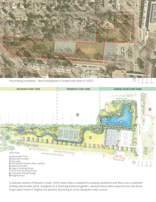
The daylighted stream cascades into this precisely calibrated stormwater pond — one whose geometries reflect both the order of the University grid established by Jefferson and the meander of Piedmont stream hydrology. The indigenous plant palette illustrates the spectrum of plant zones found in Virginia: the Coastal Plain represented in the area around the stormwater basin; the Piedmont represented in the intermediate stream zone; and the upland Blue Ridge represented in the upper reaches of the valley. It thus serves as a teaching botanic garden for students in the landscape architecture and environmental sciences programs. Certain genera of plants were purposefully selected because they had species representation in two or three physiographic provinces — Magnolia, Leucothoe, Ilex, and Amelanchier, for example.
Materials incorporated into the project were selected for their vernacular character. Stone walls — comprised of Shenandoah field stone with Pennsylvania bluestone caps - reference the local use of stone in the Civil War Cemetery walls as well as the more regional connection to the geology of the mid-Atlantic. In addition, chain link fencing found around the tennis and basketball courts was used in the detailing of bridge railings.
Since its opening, this project has been successful beyond the University’s greatest hopes. Now referred to as the New Dell, the park attracts people from the surrounding university and community neighborhoods. Wildlife sightings have been numerous — deer, red fox, ducks, frogs, turtles, fish, insects, songbirds, and great blue heron have populated the waters, edges, and meadow areas in rapid succession. As the stream and pond environment successfully respond to storms of varying intensities, the New Dell is emerging as an exemplar of innovative regional stormwater management.
Project Resources
Landscape Architect Project Team
Nelson Byrd Woltz Landscape Architects
Charlottesville, Virginia:
Warren T. Byrd, Jr., FASLA, Principal in Charge
Kennon Williams,
Senior Project Manager
Kent Dougherty, Staff Designer
Emmanuel Didier, Staff Designer
Robin Carmichael, Staff Designer
Jason Kreuzer, Staff Designer
Theresa
Steward, Staff Designer
Client
University of Virginia, Office of the Architect, Charlottesville, Virginia:
Mary V. Hughes, FASLA, University Landscape Architect
Fluvial Engineers/Hydrologists/
Ecologists
Biohabitats of Maryland, Inc., Baltimore, Maryland:
Tom Burkett, Project Manager
Vince Sortman, Fluvial Geomorphologist:
Biohabitats of Virginia, Inc.:
Ecologist Lee Mallonee, ASLA, Project Manager
Civil Engineers
Nitsch Engineering, Inc., Boston, Massachusetts:
Stephen Benz, P.E., LEED®
PHR&A Engineering, Inc., Charlottesville, Virginia:
John Reno, Project Manager
Project Management/Interface with John Paul Jones Arena project
VMDO Architects, Charlottesville, Virginia:
Chris Weatherford, Project Manager
Featured Products
Steel Light Poles and Luminaires
Spring City Electrical Manufacturing Company
Steel Anchors for Wood Construction
Simpson Strong-Tie Company Inc.
Coir Fiber Erosion Control Matting
Rolanka International, Inc.
Stone Coping on Walls, Spillways, and Pond Edge
Luck Stone Corporation
Plants and Planting:
Ivy Nursery
Organic Compost
Panorama Pay-Dirt
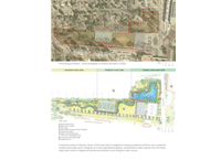
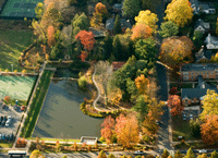
Site Plan with aerial phoo of existing conditions prior to design and construction (Photo: University of Virginia)
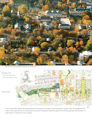
Context Plan (Photo: Will Kerner)
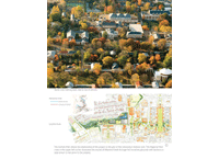
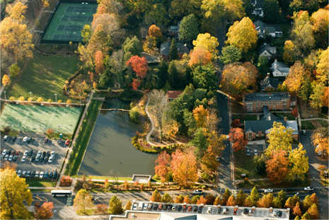
This aerial view highlights the designed juxtaposition between the meandering north side of the Dell, reflective of typical stream morphology as well as this sites topography, and the linear south side that responds to the grid of the historic University. (Photo: Will Kerner)
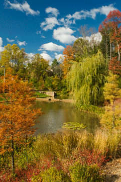
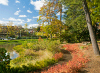
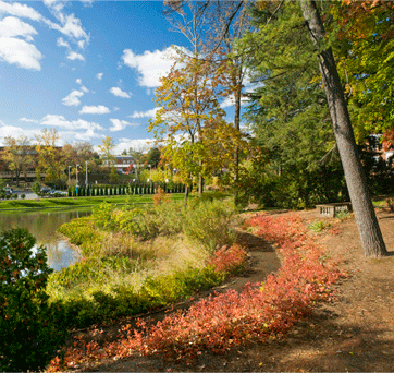
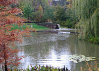
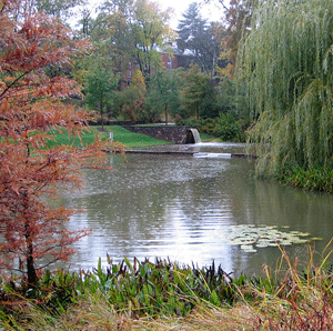
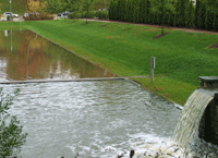
Autumn view from the Emmet Street edge of the project across native Virginia hydric site plantings of bald cypress red twig dogwood, wetland grasses, and aquatic perennials. The stone weir wall and spillway are seen at the center of this view. (Photo: Darren Higgins)
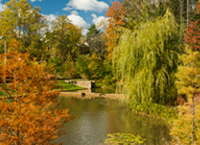
The meandering path on the north side of the stormwater pond has become popular for strolling. A diverse mosaic of native plant species contrasts with the evergreen order and simplicity of the manicured terrace lawn bank and singular lines of water oak and white cedars across the pond. (Photo: Darren Higgins)
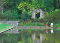
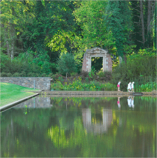
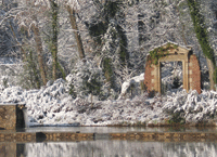
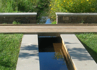
The two-foot wide weir is an invitation to explore the water moving from the forebay to the main pond. The gate in the background is a historic garden folly that was stabilized and preserved in place for this project. (Photo: Hara Woltz)
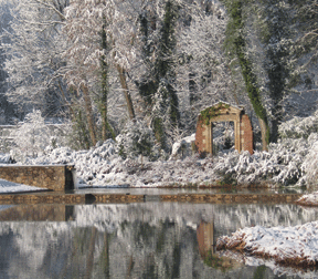
View of spillway and weir at normal winter water flows with garden folly in background. (Photo: Nelson Byrd Woltz Landscape Architects)
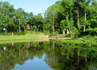
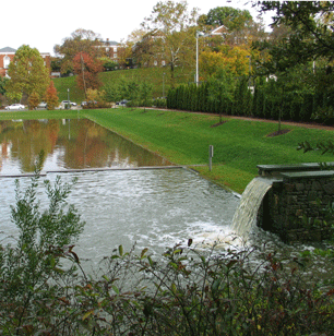
Summer view of stormwater pond from the sidewalk along Emmet Street. (Photo: Nelson Byrd Woltz Landscape Architects)
"Brava! In an era of environmental clichés, this project is truly original. We love the context of its location at one of the best landscape architecture schools in the world. The geometry and curvature make it romantic and rich. It works well in all four seasons. When youre in college, youre looking for these kinds of places."
— 2009 Professional Awards Jury
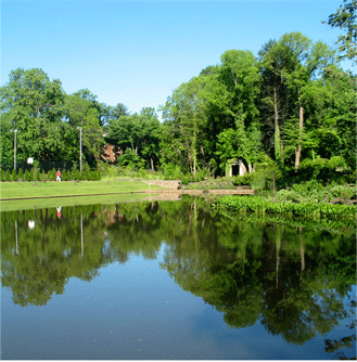
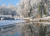
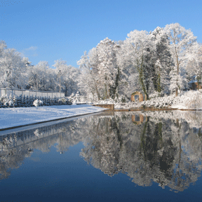
Winter view of stormwater pond. (Photo: Nelson Byrd Woltz Landscape Architects)
Framed view of pond, weir, forebay, and spillway at high storm flow. (Photo: Nelson Byrd Woltz Landscape Architects)
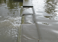
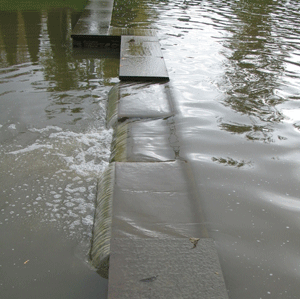
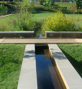
The flow of water from the sediment forebay is controlled by the stone weir that separates the forebay from the pond. Various storm events, such as 2-year versus 10-year storms, are calibrated by the stepped openings in the weir. (Photo: Nelson Byrd Woltz Landscape Architects)
High volume flow after a major storm. The resurrected Meadow Creek is channeled through the spillway into the sediment forebay where it catches particulates from upstream erosion and urban runoff. (Photo: Nelson Byrd Woltz Landscape Architects)
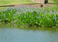
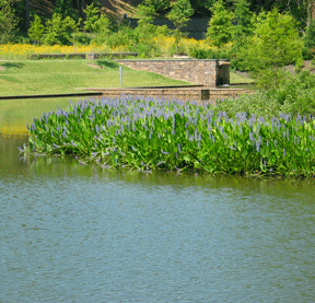
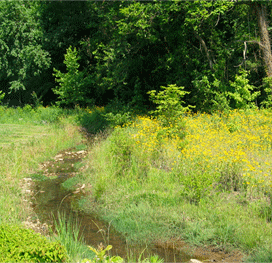
Summer view of pond, purple-blooming pickerel weed, weir, and spillway at normal stream flow. The drift of yellow flowers in the background are coreopsis amid native meadow grass in the reclaimed stream course area. (Photo: Nelson Byrd Woltz Landscape Architects)
The juncture of the natural stream with the constructed spillway, mediated by a low stone wall and wood bridge. (Photo: Nelson Byrd Woltz Landscape Architects)
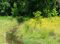
Representative segment of the designed stream course, where the stream serves as a demarcation between usable lawn areas to the left and rain garden/meadow areas to the right. Prior to this project, the stream was completely buried in pipes. (Photo: Nelson Byrd Woltz Landscape Architects)