

«previous pageANALYSIS & PLANNING CATEGORY
Honor Award
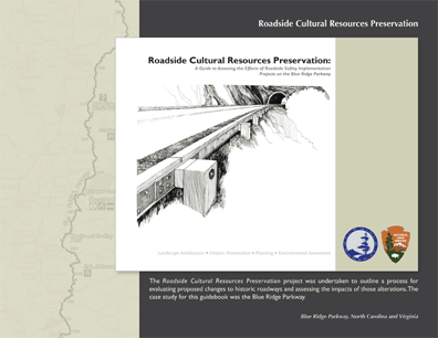
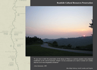
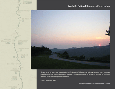
Roadside Cultural Resources Preservation: A Guide to Assessing the Effects of Roadside Safety Implementation Projects on the Blue Ridge Parkway, Blue Ridge Pkwy, NC & VA
The Jaeger Company, Gainesville, GA
client: National Park Service, Blue Ridge Parkway
Project Statement
This guidebook outlines a process for evaluating proposed changes to Park Roads and Parkways and the potential impact of those changes. The primary goal is to preserve the significance and integrity of America's historic roadways while allowing for sensitive implementation of contemporary safety standards. The project Landscape Architect facilitated the creation of this process, now adopted by federal agencies. Adherence to this process insures that distinctive design achievements inherent to historic roadways will be preserved.
Project Narrative
Many of the Nation's great scenic roadways are associated with our national parks and parkway systems. As the National Park Service (NPS) looks forward to celebrating its 100th anniversary, many of its managed resources are showing wear from generations of visitor use. Today's historic roadways are under constant pressure to handle greater volumes of traffic and to incorporate contemporary safety standards. The demand for needed repairs and safety upgrades threatens to alter the face of our nation's historic roadways.
In response to these demands, the primary objective for this project was to focus on a method for maintaining the historic integrity of cultural resources associated with historic roadways, while identifying creative means to implement additional safety features where necessary. The Blue Ridge Parkway (BLRI) is a model example of how the NPS' values of aesthetic conservation and public access can be successfully integrated and executed, and therefore serves as a worthy case study for applying this method. Further, this methodology is to be used in accomplishing the Section 106 process for proposed roadway improvement projects. The document will guide NPS staff in performing project scoping and effect determinations for construction activities proposed within the limits of any administered historic park road. The ultimate goal of the guidebook is to provide an effective tool for preserving all of our nation's historic roadways.
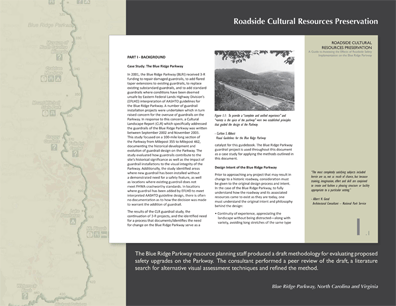
The NPS/BLRI resource planning staff originally recognized the need and conceived the idea of a method for evaluating safety undertakings proposed within the historic designed roadway and retained the Landscape Architecture consultant to perform peer review and refinement of the process and development of the overall guidebook document. The Landscape Architect conducted a series of meetings with an advisory committee comprised of the Federal Highway Administration (FHWA), the State Historic Preservation Offices (SHPO) of North Carolina and Virginia, the Advisory Council on Historic Preservation and NPS staff. The draft methodology was further analyzed and tested to reach an agreed upon process by these agencies for evaluating the need for additional safety features on the BLRI and the effects these features will have on historic resources. Input from the meetings, along with field testing of the methodology on sections of the Parkway, provided further refinement, ultimately resulting in this Guidebook.
At the onset of the project, the Landscape Architect performed a literature search to locate similar studies that adequately incorporate three aspects of effect determination that allow for (1) describing the visual and historic character of the Parkway's roadside landscape; (2) assessing the ability of a particular roadside location to visually absorb the introduction of a new safety feature; and (3) applying the criteria of adverse effect to more precisely determine the degree to which a historic landscape would be effected. Resources found in the literature search were used in the process of evaluating the proposed NPS/BLRI methodology and to identify the most current approach to assessing changes in the visual character and historic integrity of a scenic road corridor. Other resources studied by the consultant included: the original plans for the BLRI known as Parkway Land Use Maps (PLUMS), which illustrate the original design elements; case studies of similar historic roadways; creative solutions used to address safety problems; BLRI Geographic Information System (GIS) data; and intensive field study of the BLRI.
An addition to the guidebook, identified early on in the project, was the importance of providing a thorough understanding of the Blue Ridge Parkway and its original design intent. This information was developed by the Landscape Architect, presented to the advisory committee, and included in the final Guidebook so that users will begin each project with a shared understanding of the cultural resources that may be impacted by change. Details on infrastructure and roadway geometry were analyzed for safety and design intent and the scenic nature of the roadway.
The following is a summary of the methods included in the Roadside Safety and Effect Screening Process:
Prior to considering a new roadside safety feature, a two-step evaluation process shall be implemented.
Step 1: The Safety Screening Method determines if placement of a safety feature is warranted. This step should be performed by the NPS and FHWA throughout the limits of each project area during project scoping to evaluate and determine the need for roadside safety treatment using the following five screening criteria: (1) Accident History (roadway-related), (2) Embankment Height, (3) Unusual Roadway Geometric Conditions, (4) Natural Vegetation on a Fill Slope, and (5) Available Shoulder Width.
Step 2: An Historic Integrity and Effects Screening is then performed to determine the presence of sensitive cultural or environmental resource conditions. This process involves an inventory of existing roadway conditions such as: roadside features, road alignment, landform and vegetation to assess the ability of the landscape to visually absorb the proposed safety feature; and a historic resource assessment to help determine the impact a proposed feature would have on the resource. If a need for a safety feature is demonstrated and the Historic Integrity and Effects Screening process reveals that there is minimal adverse effect, then additional guardrail and/or barrier end treatment upgrades may be designed and installed according to Parkway guidelines and sited to minimize resource impact.
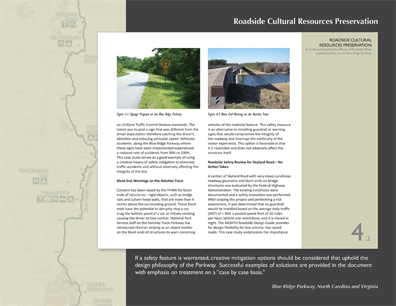
The degree to which an undertaking would affect the overall context or "cultural landscape character area" of a roadway is dependent upon the proposed new safety feature's visual compatibility with, and contrast to, the qualities of the landscape area's other physical features and how it would change the historic fabric and composition of the context. These are referred to in the guidebook as Thresholds of Change and include evaluation of the aspects of historic integrity such as materials, workmanship and feeling/aesthetics. These elements are focused on the historic fabric of bridges, tunnels, and guardwall features or roadside areas where a safety improvement is proposed. The degree or severity of change caused by the undertaking on a cultural landscape character area and its associated historic features would be determined by the change to the historic fabric and the landscape character area's ability to visually absorb the introduction of a new physical feature.
Setting, design and spatial organization are used to describe the visual character and complexity of a cultural landscape character area and thus directly relate to the landscape's visual absorption capability. Before the cultural landscape character area's Visual Absorption and Awareness of Roadside can be determined, it needs to be understood in terms of: (1) Viewer Sightlines, and (2) Landscape Visual Complexity. The landscape's ability to visually absorb changes is a function of where the viewer is located relative to the introduced feature, the viewer's sightline, and the degree of visual complexity of the landscape that is the backdrop for the feature.
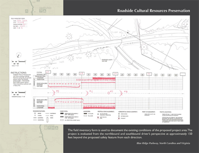
Field inventory is the initial step in the Historic Integrity and Effects Screening process and is used to determine the level of intensity that the impact of a proposed safety improvement would have on the existing conditions of the Parkway. The field inventory form incorporates the appropriate portion of the PLUM, documenting the existing design of the parkway as well as the location of the proposed safety feature. Information is then collected on the lower portion of the field form containing corresponding station points and grided plan view of the roadway. The collected data includes existing roadside features, density of vegetation, landform, vertical road alignment and horizontal road alignment to be used in assessing landscape's ability to absorb a new safety feature. Two forms will be required for each field inventory to assess the proposed project area from a northbound and southbound direction. The point of assessment for each direction is to be located 150 feet beyond the proposed safety feature.
For purposes of assessing potential impacts to historic resources, the thresholds of change for the intensity of an impact is evaluated in terms of alteration of the historic fabric of the Parkway. Based on the Historic Resource Study for the Parkway contributing historic resources are very likely to occur within any proposed project area. These resources include elements of the Parkway such as bridges, road shoulder and views. As part of Step 2 in the Screening Process, the historic resources of a project area must be evaluated to determine the historic integrity of the resources. The Historic Assessment of Roadside Features must take the form of a Cultural Landscape Report and must be conducted by a NPS approved professional referencing the period of significance identified in the Parkway's Historic Resource Study.
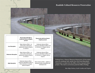
The following Effect Findings would be determined based on the historic integrity of the resources and the landscape's ability to visually absorb a new feature: (1) Negligible or No action taken; (2) Minor Impact: alteration of a resource which possesses low historic integrity where safety improvement could be made without diminishing the overall historic integrity of the project area due to the ability of the landscape to visually absorb the safety feature; (3) Moderate Impact: alteration of a resource which possesses high or moderate historic integrity where implementation of a safety improvement would diminish the overall integrity of the resources of the project area; and (4) Major Impact: alteration of a resource which possesses high or moderate historic integrity to provide a safety upgrade which occurs in an area with moderate or low landscape absorption. Proposed alterations to resource(s) which result in impairment of that resource are also considered a Major Adverse Effect.
Prior to undertaking any project that could result in the change of an historic roadway's important factors surrounding the design and construction of that roadway must be fully understood. If change is warranted, then there must be a process in place to guide decisions surrounding that change and documentation of the process prior to implementation. This method takes into account original design intent, historic and visual resource preservation and provides for creative solutions to mitigate safety issues where warranted. Preservation is also critical to the NPS' effort to promote sustainable development. In the case of historic roadways, maintaining the integrity of these cultural resources sustains the visitor's experience, the history and natural environment of the place for future generations of Park users.
The NPS and FHWA have adopted this guidebook as the agreed upon process for determining when a current design and safety guidelines will be implemented on projects for the Federal Lands Highway Program and Park Roads and Parkways programs. These methods will continue to be evaluated and refined by these two entities as roadway improvement projects are undertaken on the BLRI.
Project Resources
Project Team
The Jaeger Company, Landscape Architecture
Landscape Architects
Dale Jaeger, FASLA, Principal Landscape Architect
Emmeline Morris, ASLA, Project Manager
William Shealy, ASLA, Assistant Project Manager
Ian Firth, FASLA, Parkway Historian
Engineer/Environmental Planning
HDR Engineering, Inc. of the Carolinas, Engineering
NPS Landscape Architect
Gary Johnson, Chief, Resource Planning & Professional Services
Blue Ridge Parkway
Project Technical Advisory Group
National Park Service
Blue Ridge Parkway
Denver Service Center
Southeast Regional Office
Federal Highways Administration / Eastern Federal Lands Highway District
North Carolina State Historic Preservation Office
Virginia
State Historic Preservation Office
Advisory Council on Historic Preservation
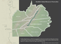
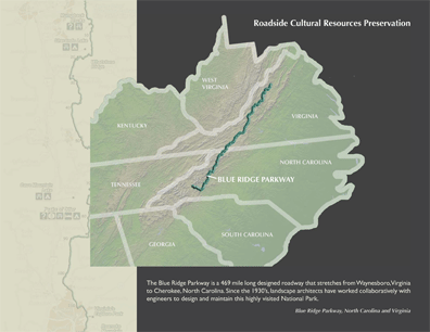
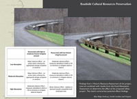
The Blue Ridge Parkway is a 469-mile long designed roadway that stretches from Waynesboro, Virginia to Cherokee, North Carolina. Since the 1930's landscape architects have worked collaboratively with engineers to design and maintain this highly visited National Park. (Photo: The Jaeger Company)
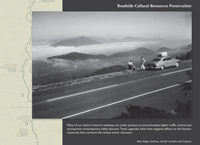
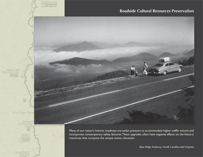
Many of our nation's historic roadways are under pressure to accommodate higher traffic volume and incorporate contemporary safety features. These upgrades often have negative effects on the historic resources that comprise the unique scenic character. (Photo: National Park Service — Blue Ridge Parkway Archives)
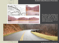
The Roadside Cultural Resources Preservation project was undertaken to outline a process for evaluating proposed changes to historic roadways and assessing the impacts of those alterations. The case study for this guidebook was the Blue Ridge Parkway. (Photo: National Park Service)
The Blue Ridge Parkway resource planning staff produced a draft methodology for evaluating proposed safety upgrades on the Parkway. The consultant performed a peer review of the draft, a literature search for alternative visual assessment techniques and refined those methods. (Photo: National Park Service)
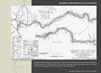
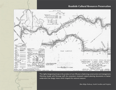
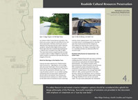
This highly designed Parkway is the product of over 50 years of planning, construction, and management. Working closely with Parkway staff, the consultant reviewed original planning documents to better understand the design intent which shaped this national treasure. (Photo: National Park Service)
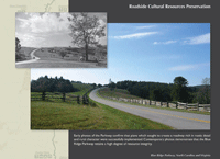
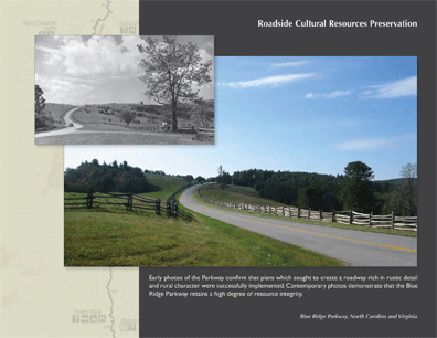
Early photos of the Parkway confirm that plans which sought to create a roadway rich in rustic detail and rural character were successfully implemented. Contemporary photos demonstrate that the Blue Ridge Parkway retains a high degree of resource integrity. (Photo: National Park Service — Blue Ridge Parkway and The Jaeger Company)
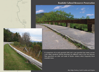
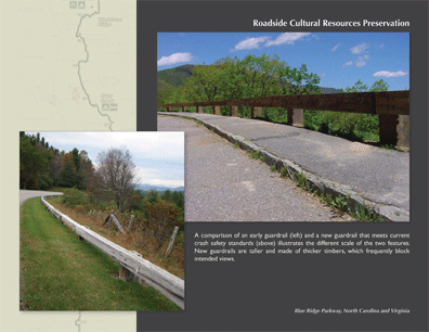
A comparison of an early guardrail (left) and a new guardrail that meets current crash safety standards (above) illustrates the different scale of the two features. New guardrails are taller and made of thicker timbers, which frequently block intended views. (Photo: The Jaeger Company)
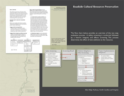
The flow chart provides an overview of the two-step evaluation process. A safety screening is conducted followed by a historic integrity and effects screening. This process determines the effect of new additions to the resource. (Photo: National Park Service)
"A beautifully crafted study that deals with safety issues and still preserves what has always been there. The grading diagrams are fascinating. The visual quality makes it an exciting experience to drive through. Its a model for the nation."
— 2009 Professional Awards Jury
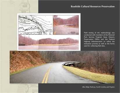
Field testing of the methodology was conducted with members of the National Park Service. Virginia's State Historic Preservation Office and the Federal Highway Administration to refine the evaluation process as well as the forms used for collecting field data. (Photo: National Park Service)
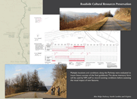
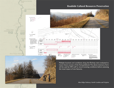
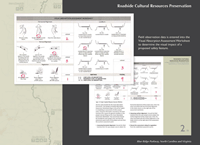
Multiple locations and conditions along the Parkway were evaluated to insure future success of the final guidebook. The above inventory form will be used by NPS staff to record existing conditions before assessing the visual impact of new features. (Photo: National Park Service)
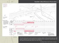
Sample field inventory form issued to document the existing conditions of the proposed project area. The project is evaluated from the northbound and southbound driver's perspective at approximately 150 feet beyond the proposed safety feature from each direction. (Photo: National Park Service)
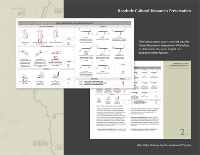
Field observation data is entered into the Visual Absorption Assessment Worksheet to determine the visual impact of a proposed safety feature (Photo: National Park Service)
Findings from a Historic Resource Assessment of the project area are combined with results from the Visual Absorption Assessment to determine the effect of the proposed safety project. The matrix summarizes potential effects findings. (Photo: The Jaeger Company)
If a safety feature is warranted, creative mitigation options should be considered that uphold the design philosophy of the Parkway. Successful examples of solutions are provided in the document with emphasis on treatment on a "case by case basis." (Photo: National Park Service)
"In any area in which the preservation of the beauty of Nature is a primary purpose, every proposed modification of the natural landscape, whether it be by construction of a road or erection of a shelter, deserves to be most thoughtfully considered." — Arno B. Cammerer, Director, National Park Service (Photo: National Park Service)