

«previous pageANALYSIS & PLANNING CATEGORY
Honor Award
Los Angeles River Revitalization Master Plan, Los Angeles, CA
Mia Lehrer + Associates/ Civitas, Inc./ Wenk Associates, Los Angeles, CA
client: City of Los Angeles, Bureau of Engineering
Project Statement:
The Los Angeles River Revitalization Master Plan represents the culmination of over 10 years of river revitalization activism, bringing together public agencies and stakeholders for a common goal. The plan shapes a bold vision to transform a channelized flood control conveyance into a significant regional recreational and ecological resource. The Master Plan signals a new era for Los Angeles, replacing infrastructure designed for automobiles and real estate investment with a public greenway corridor.
Project Narrative:
The Los Angeles River Revitalization Master Plan aims to transform 32 miles of concrete-lined River into public green space in the heart of one of America's most populated cities. Channelized by the Army Corps of Engineers over 70 years ago for flood prevention, multiple generations of Angelinos have grow up unaware of the river, or thinking that concrete channels with graffiti and shopping carts are the norm. In 2005 key civic leaders joined forces to fund a visionary and technical look at transforming the river into a new amenity, a source of socio-economic revitalization and a crucial step in the restoring green space the City of Sprawl.
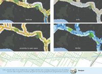
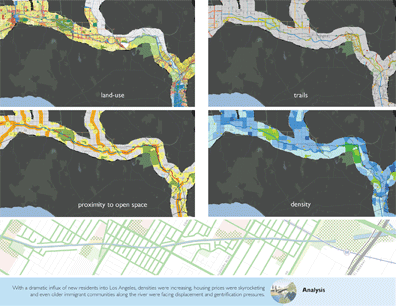
Extensive analysis studies included transportation infrastructure, land ownership, property jurisdiction, open space types, hydrology, water velocity, groundwater basins, contamination plumes, youth density, zero car households, pedestrian gap, bicycle and equestrian gap and others were completed after the first four months. After this data was collected and synthesized, the team verified the need for a park and open system identifying opportunities to completely change the river into a green, living system, an urban design centerpiece.
The plan is the result of a comprehensive analysis including land use, water quality, ecology, hydrology, demographics, natural systems and urban river precedent studies. The client group visited Denver Colorado and other cities with restored rivers to gain a better sense of the natural and economic revitalization potentials. GIS mapping was utilized to study open space distribution and connectivity opportunities. Analysis was performed in an integrated and collaborative team approach looking at flood control, governance, natural systems and public open space at the same time to maximize potential benefits.
The river is one of the few elements that cross geographical, economic and social boundaries in the City. It flows from and through well off, higher income neighborhoods, commercial districts and poorer areas. Since the river has been treated as a single purpose flood control device there is little variation in the infrastructural character in any location. In other words, not much favoritism has been shown in enhancing the river in any area. As the master plan was developed public workshops were held along the length of the river in locations that were as close to it as possible and with as many stakeholders as possible. Workshops were held in public parks, at schools, community centers and other public facilities. Participants gained a better understanding of their relationship to the river and the part the River could play in a providing much needed open space, recreation and economic revitalization while maintaining its flood control functions.
Meetings were held with all of the interested public agencies, the neighborhood councils, community groups, and non-profits to maintain a dialogue and provide education about the potential river re-vitalization benefits. Communication was seen as the best antidote to presumptions of private development and gentrification agendas. The project included a peer review committee comprised of highly qualified and nationally recognized leaders in landscape architecture, architecture, urban design and water resource engineering. An advisory committee included representatives of over 30 agencies and organizations who represented academic institutions, cultural organizations, state agencies, preservation organizations and private sector economists.
Design was used to explore and demonstrate opportunities made possible with a revitalized River. Twenty 'Community Opportunity Areas' were carefully selected along the River corridor to illustrate what might be feasible through implementation of various improvement scenarios. Following the development of the planning goals study areas were selected and concepts illustrated at varying scales from large scale mixed use district redevelopment to site specific park development. The concepts and images generated from these design studies have been instrumental in changing public perception and visions for the River.
The Master Plan developed the following goals with recommendations to achieve a long term, phased approach:
- Revitalize the River
- Green the Neighborhoods
- Capture Community Opportunities
- Create Value
- Develop Community Planning Frameworks based on the River
- Create a River Management Framework
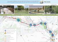
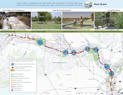
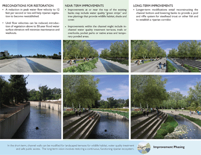
Revitalizing water quality (1) enhanced flood storage, to slow flow velocities to enable reintroduction of vegetation; (2) enhanced water quality, through regional-scale stormwater treatment at River confluences, and localized "treatment terraces" at storm drain outfalls; (3) enhanced public access within the channel via terraces and ramps, small pocket parks and ponded areas; and (4) a restored riparian ecosystem. These guidelines for stormwater management and sustainable building will advance the City's "green agenda."
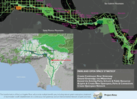
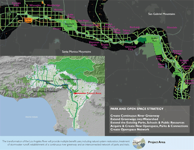
Greening the neighborhoods extend the River's influence into adjacent neighborhoods, encompassing five goals: (1) creation of a continuous River Greenway that serves as the City's "green spine;" (2) reconnect neighborhoods to the River through a system of "green streets;" (3) recapture underutilized or brownfield sites in park-poor areas as neighborhood parkland, and incorporating stormwater management practices into all public landscapes; (4) enhance River identity through signature bridges and gateways, and through programmed events; and (5) incorporate public art along the River.
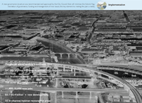
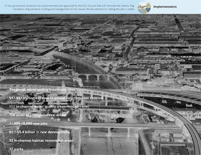
Create Value: Making the River green and accessible is expected to transform an undervalued asset into a valued amenity. Estimates of economic benefits accruing to the proposed revitalization concepts for five of the Opportunity Areas (combined, at full build-out) range from $2.7 to $5.4 billion in new development, 11,000 to 18,000 new jobs, and a long-term tax revenue increase ranging from $47 to $81 million annually.
Develop community Planning Frameworks based on the River: A new governance structure was proposed and adopted to overcome a highly divided system of river management — a critical precursor to change. Since the completion of the master plan, the Bureau of Engineering established the River Project Office tasked with implementing the Master Plan goals. The city Planning Department implemented the River Improvement Overlay (RIO), district design and environmental guideline requirements for developers with property adjacent to the river. All projects must get approval from the LA RIO prior to obtaining a building permit. Projects are evaluated for their watershed, urban design and mobility factors. This will enable the city to better coordinate land use development along the 32-mile river corridor.
Create a River Management Framework: The formation of a corporation as the entrepreneurial piece to direct public and private financing for river related and neighborhood revitalization projects. Their main functions is river related improvements, economic development and public space management and maintenance. Lastly, a foundation is to be formed as the philanthropic not-for-profit organization to seek grants, donations and partnerships to further the environmental, educational, cultural, social justice and sustainability issues for the river and adjacent communities.
The master plan is intended to be a 25-50 year blueprint for implementing comprehensive improvements that would make the River one of the city's most treasured landmarks and a catalyst for a sustainable environment.
Project Resources
Landscape Architecture, Recreation & Open Space Design
Mia Lehrer + Associates
Team Leader/Project Manager, Environmental Analysis, Engineering, Watershed & Water Quality Modeling, Agency Liaison
Tetra Tech, Inc.
Urban Design, Community Planning
Civitas, Inc.
Urban Design, River Corridor Planning
Wenk Associates
Urban Design
HNTB Architecture, Inc.
Community Outreach, Governance Support, Master Planning Support
GCG Rose & Kindel
Community Outreach, Master Planning Support, EIR & EIS Support
The Robert Group and Transportation & Land Use Collaborative of Southern California
Governance/ Implementation
Urban Partners and Asset Strategies
Community Outreach
Urban Semillas and David Marquez
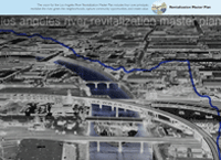
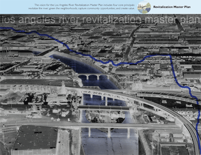
Revitalization Master Plan The vision for the Los Angeles River Revitalization Master Plan includes four core principals; revitalize the river; green the neighborhoods capture community opportunities; and create value. (Photo: Mia Lehrer + Associates, Civitas, Inc. & Wenk Associates, Tetra Tech, Inc.)
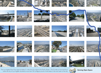
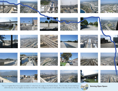
Existing Open Space The Los Angeles River flows approximately 51 miles from it's origin to the Pacific Ocean. The 32 miles of river that flows within the city of Los Angeles represents more than 750 contiguous acres of real estate, in the very heart of the city. (Photo: Mia Lehrer + Associates, Civitas, Inc. & Wenk Associates, Tetra Tech, Inc.)
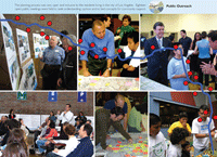
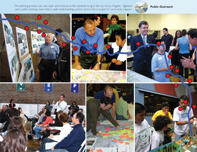
Public Outreach The planning process was very open and inclusive to the residents living in the city of Los Angeles. Eighteen open public meetings were held to seek understanding, opinion and to test concepts for community support. (Photo: Mia Lehrer + Associates, Civitas, Inc. & Wenk Associates, Tetra Tech, Inc.)
Analysis With a dramatic influx of new residents into Los Angeles, densities were increasing, housing prices were skyrocketing and even older immigrant communities along the river were facing displacement and gentrifications pressures. (Photo: Mia Lehrer + Associates, Civitas, Inc. & Wenk Associates, Tetra Tech, Inc.)
Water Quality Opportunities to revitalize the river's water quality within and adjacent to its' existing right-of-way include recommendations for flood storage, water quality, public access and ecosystem restoration. (Photo: Mia Lehrer + Associates, Civitas, Inc. & Wenk Associates, Tetra Tech, Inc.)
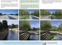
Improvement Phasing In the short-term, channel walls can be modified for landscaped terraces for wildlife habitat, water quality treatment and safe public access. The long-term vision involves restoring a continuous, functioning riparian ecosystem. (Photo: Mia Lehrer + Associates, Civitas, Inc. & Wenk Associates, Tetra Tech, Inc.)
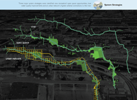
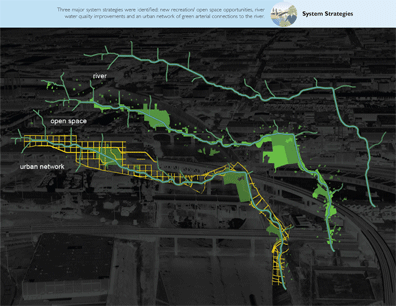
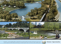
System Strategies Three major system strategies were identified: new recreation/open space opportunities, river water quality improvements and an urban network of green arterial connections to the river. (Photo: Mia Lehrer + Associates, Civitas, Inc. & Wenk Associates, Tetra Tech, Inc.)
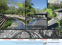
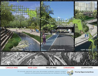
Priority Opportunity Areas 20 community opportunity study areas demonstrated revitalization potential, ecological restoration and the potential improvements that river revitalization can bring. (Photo: Mia Lehrer + Associates, Civitas, Inc. & Wenk Associates, Tetra Tech, Inc.)
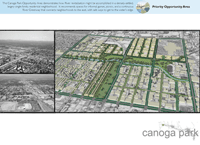
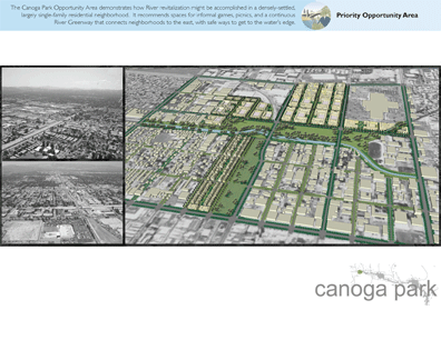
Priority Opportunity Area The Canoga Park Opportunity Area demonstrates how River revitalization might be accomplished in a densely-settled, largely single-family residential neighborhood. If recommends spaces for informal games, picnics, and a continuous River Greenway that connects neighborhoods to the east, with safe ways to get to the water's edge. (Photo: Mia Lehrer + Associates, Civitas, Inc. & Wenk Associates, Tetra Tech, Inc.)
"This project will reverse the thinking of the people of Los Angeles. The landscape architect did a wonderful job of pulling the river back and creating a compelling open space. There is a real level of reality, they arent trying to do too much. Different approaches are strategically identified and the plan shows initial improvement and then longer-term improvement. Each neighborhood received a special focus. A great education effort and politically astute."
— 2009 Professional Awards Jury
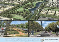
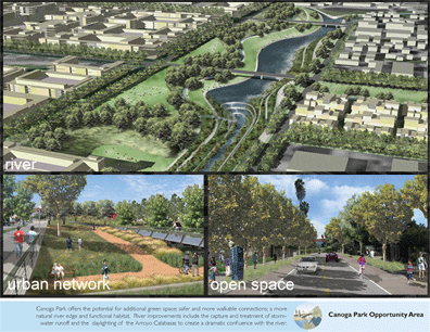
Canoga Park Opportunity Area Canoga Park offers the potential for additional green space; safer and more walkable connections; a more natural river edge and functional habitat. River improvements include the capture and treatment of stormwater runoff and the day lighting of the Arroyo Calabasas to create a dramatic confluence with the river. (Photo: Mia Lehrer + Associates, Civitas, Inc. & Wenk Associates, Tetra Tech, Inc.)
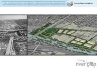
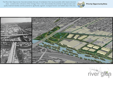
Priority Opportunity Area The River Glen Opportunity Area demonstrates the type of revitalization that may be possible within heavily-industrial areas. Located at the confluence of the Verdugo Wash, it also demonstrates the potential of regional-scale water quality treatment facilities and the potential to significantly augment ecological function and habitat value in this area. (Photo: Mia Lehrer + Associates, Civitas, Inc. & Wenk Associates, Tetra Tech, Inc.)
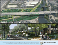
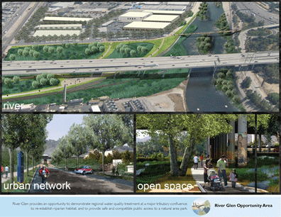
River Glen Opportunity Area River Glen provides an opportunity to demonstrate regional water quality treatment at a major tributary confluence; to re-establish riparian habitat; and to provide safe and compatible public access to a natural area park. (Photo: Mia Lehrer + Associates, Civitas, Inc. & Wenk Associates, Tetra Tech, Inc.)
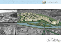
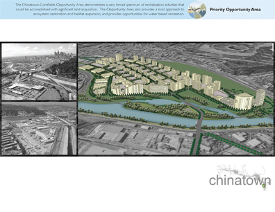
Priority Opportunity Area The Chinatown-Cornfields Opportunity/Area demonstrates a very broad spectrum of revitalization activities that could be accomplished with significant land acquisition. The Opportunity Area also provides a bold approach to ecosystem restoration and habitat expansion, and provides opportunities for water based recreation. (Photo: Mia Lehrer + Associates, Civitas, Inc. & Wenk Associates, Tetra Tech, Inc.)
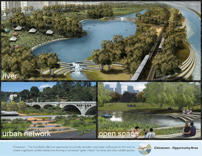
Chinatown - Opportunity Area Chinatown - The Cornfields offers an opportunity to provide recreation and water craft access to the river; to create a significant wildlife habitat area forming a connected "green ribbon" for birds and other wildlife species. (Photo: Mia Lehrer + Associates, Civitas, Inc. & Wenk Associates, Tetra Tech, Inc.)
Implementation A new governance structure was recommended and approved by the City Council that will minimize the historic fragmentation of governance, funding and management of river issues, the key element to making the plan a reality. (Photo: Mia Lehrer + Associates, Civitas, Inc. & Wenk Associates, Tetra Tech, Inc.)
(Photo: Mia Lehrer + Associates, Civitas, Inc. & Wenk Associates, Tetra Tech, Inc.)