


Honor Award
Natural Water as Cultural Water / A 30 Year Plan for Wabash River Corridor in Lafayette
Daniel (Zhicheng) Xu, Student ASLA, Undergraduate, Purdue University
Faculty Advisor: Sean Michael Rotar, ASLA
 Close Me!
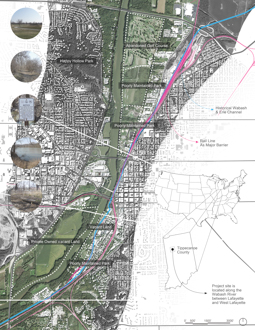
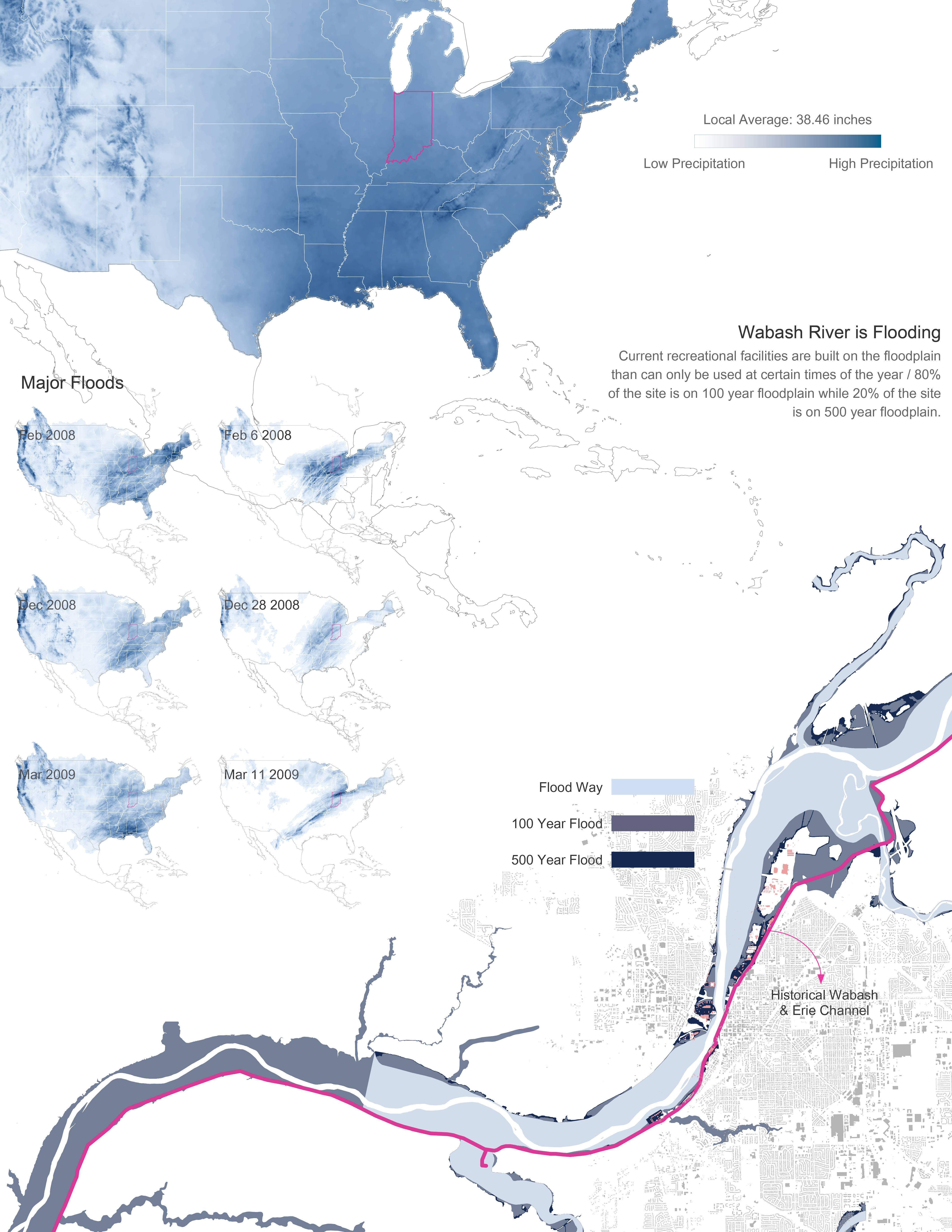
Wabash River is Flooding
Current recreational facilities are built on the floodplain that can only be used at certain times of the year / 80% of the site is on 100 year floodplain while 20% of the site is on 500 year floodplain.
Download Hi-Res ImageImage: Daniel (Zhicheng) Xu
Image 3 of 16
 Close Me!
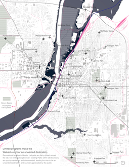
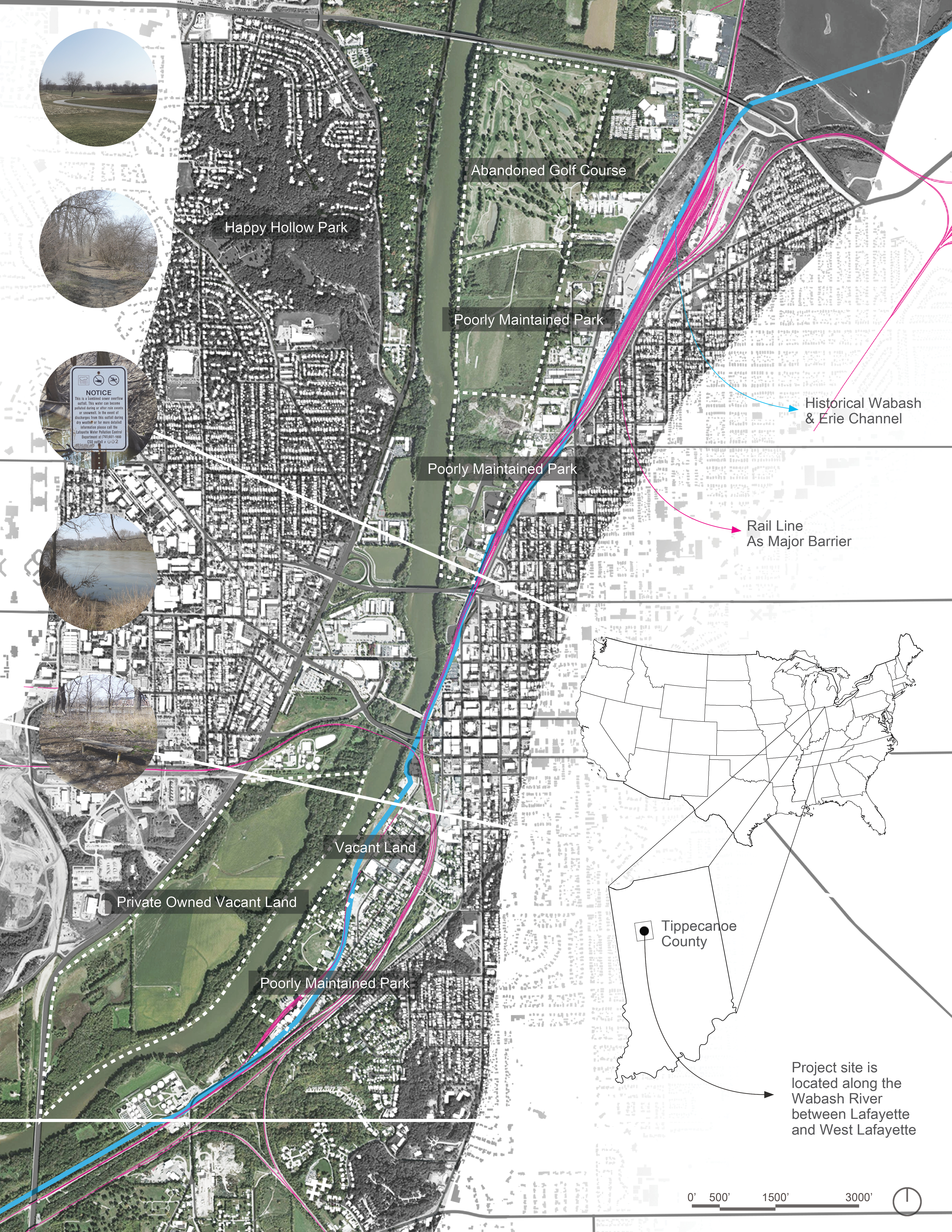
Limited Programs Make the Wabash Corridor an Unwanted Destination
Recreational facilities in Greater Lafayette are fairly spread across the city, but limited along the river. Existing Parks within site boundary are poorly maintained and disconnected, leading the river to be an unwanted, destination, and is under-appreciated by the public.
Download Hi-Res ImageImage: Daniel (Zhicheng) Xu
Image 4 of 16
 Close Me!
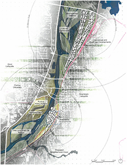
Page of Ideas
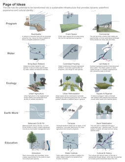
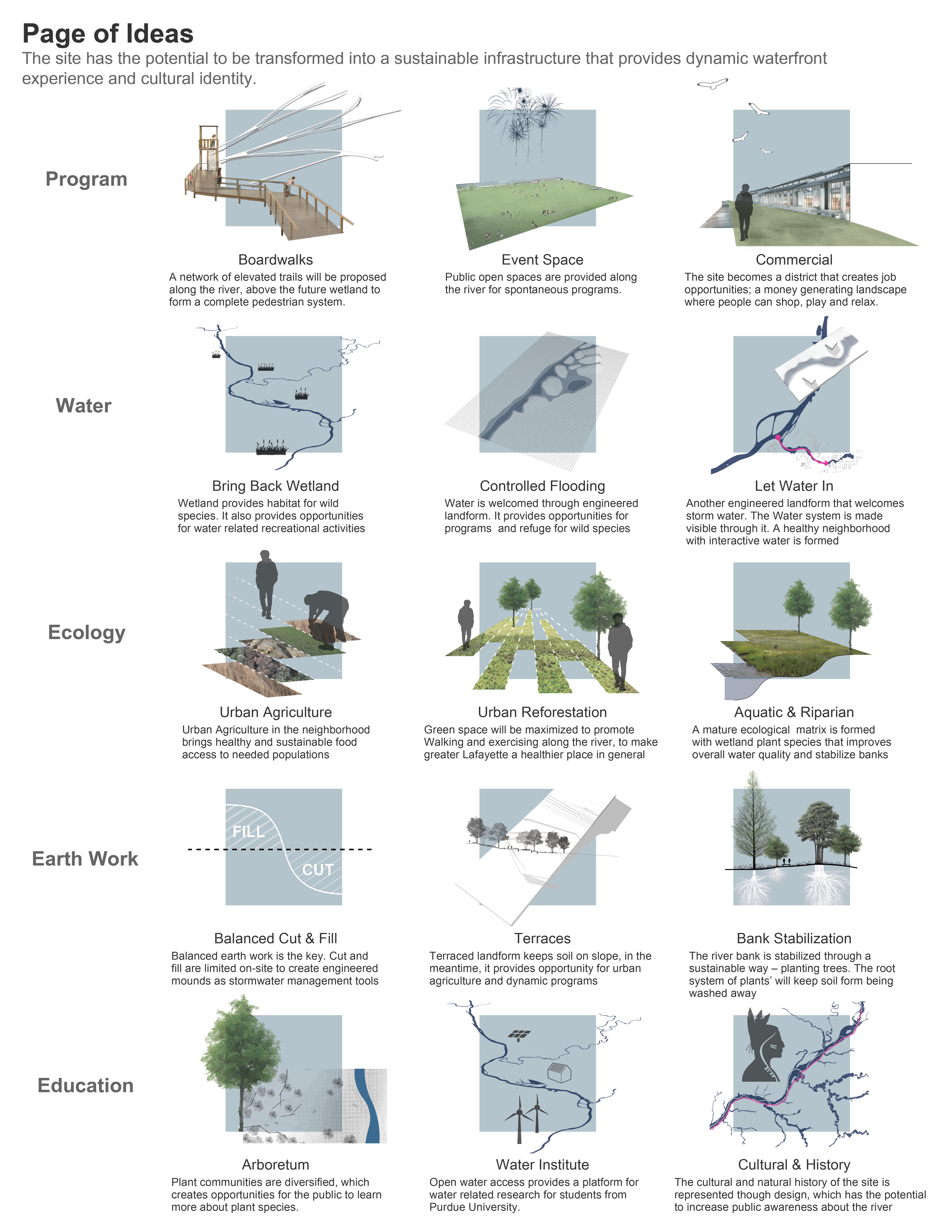
The site has the potential to be transformed into a sustainable infrastructure that provides a dynamic waterfront experience and cultural identity.
Download Hi-Res ImageImage: Daniel (Zhicheng) Xu
Image 8 of 16
 Close Me!
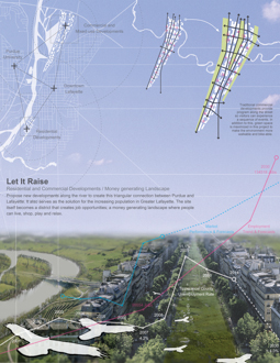
Let It Raise
Residential and Commercial Developments / Money Generating Landscape: Propose new developments along the river to create this triangular connection between Purdue and Lafayette. It also serves as the solution for the increasing population in Greater Lafayette. The site itself becomes a district that creates job opportunities: a money generating landscape where people can live, shop, play and relax.
Download Hi-Res ImageImage: Daniel (Zhicheng) Xu
Image 9 of 16
 Close Me!
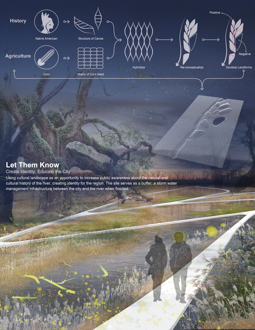
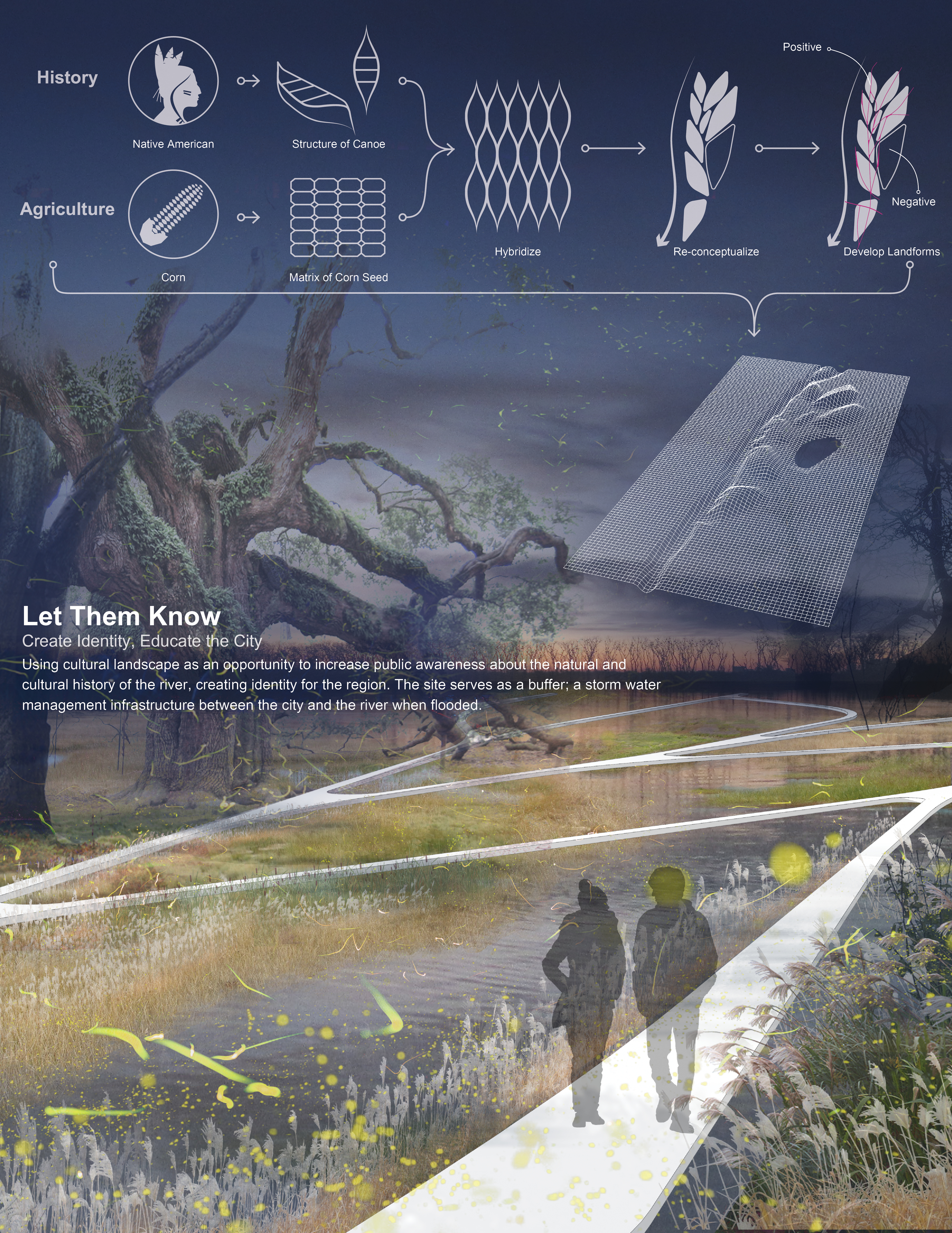
Let Them Know
Create identity, Educate the City: Using cultural landscape as an opportunity to increase public awareness about the natural and cultural history of the river, creating identity for the region. The site serves as a buffer; a storm water management infrastructure between the city and the river when flooded.
Download Hi-Res ImageImage: Daniel (Zhicheng) Xu
Image 10 of 16
 Close Me!
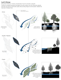
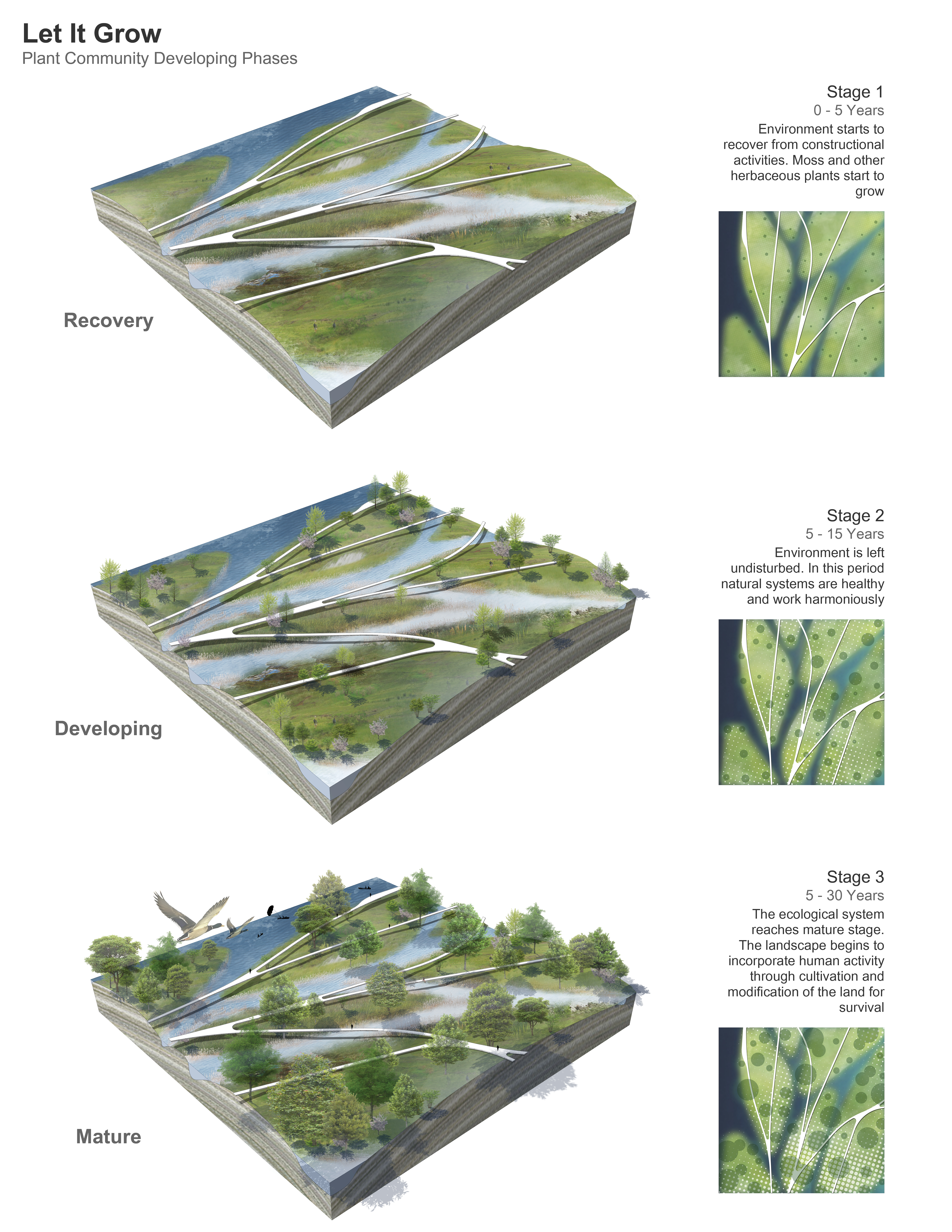
Let It Grow
Bring Back Wetland / Create a Sustainable Future for Greater Lafayette: Propose an ecological framework that adapts to the site condition over time. Bring back wetlands that clean and improve overall water quality while providing refuge for animal species. Stabilize the East bank of Wabash River.
Download Hi-Res ImageImage: Daniel (Zhicheng) Xu
Image 11 of 16
 Close Me!
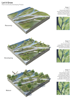
Let It Grow
Plant Community Developing Phases
Download Hi-Res ImageImage: Daniel (Zhicheng) Xu
Image 12 of 16
 Close Me!
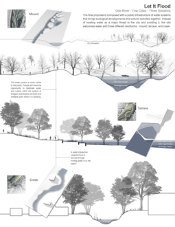
Let It Flood
One River – Two Cities – Three Solutions: The final proposal is composed with a public infrastructure of water systems that brings ecological developments and cultural activities together. Instead of treating water as a major threat to the city and avoiding it, the site welcomes water with three different landforms: mound, terrace, and creek.
Download Hi-Res ImageImage: Daniel (Zhicheng) Xu
Image 13 of 16
 Close Me!
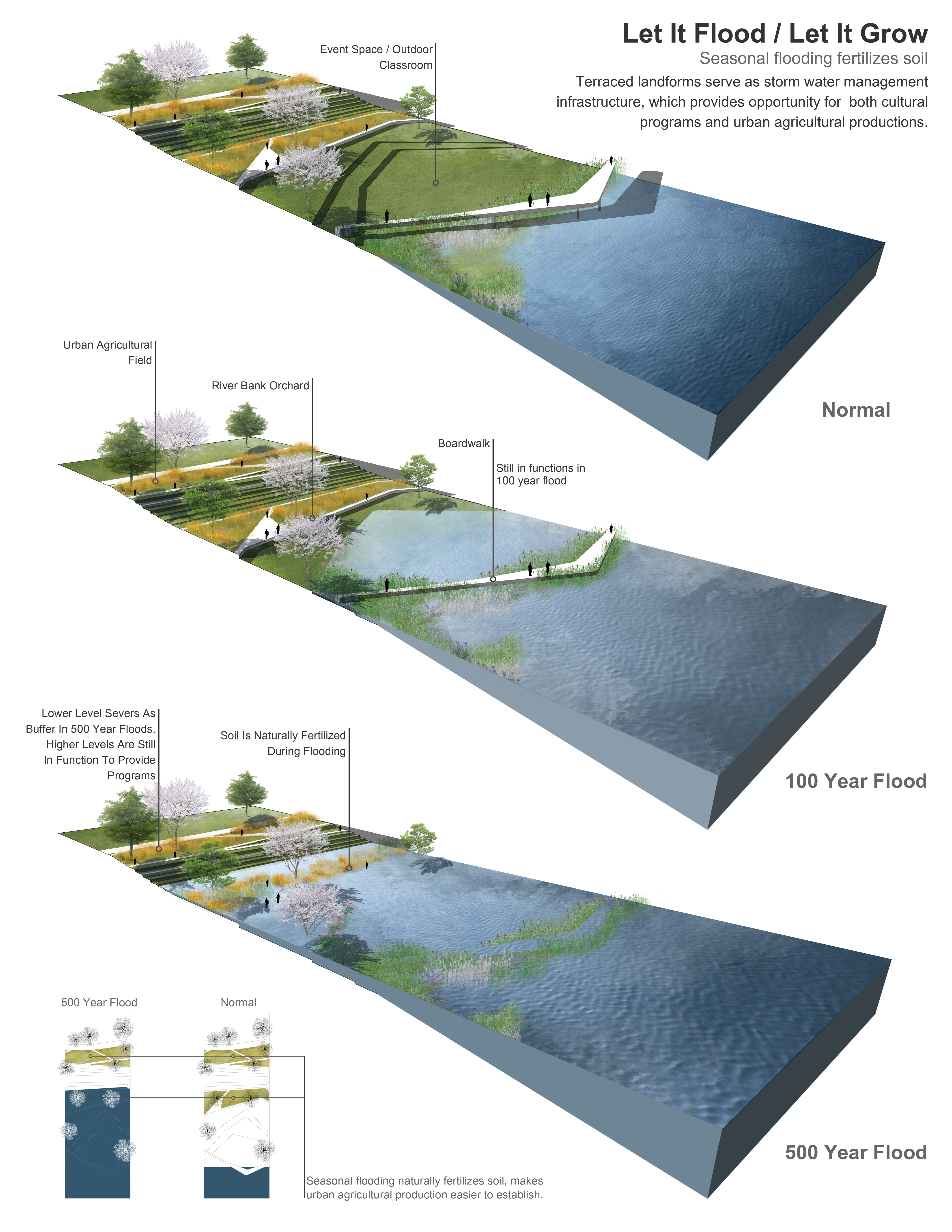
Let It Flood/Let It Grow
Seasonal flooding fertilizes soil: Terraced landforms serve as storm water management infrastructure, which provides opportunity for both cultural programs and urban agricultural productions.
Download Hi-Res ImageImage: Daniel (Zhicheng) Xu
Image 14 of 16
 Close Me!
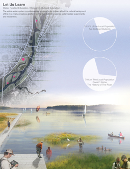
Let Us Learn
Water Related Education / Research, Cultural Education. The visible water system provides people an opportunity to learn about the cultural background of the river. It also creates a platform for Purdue students to operate water related experiments and researches.
Download Hi-Res ImageImage: Daniel (Zhicheng) Xu
Image 15 of 16
 Close Me!
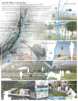
Let Us Play / Us Go
Provide connection To the Site / Create Programs Along the River: Reconnect the site to cities. Provide programs. Propose bridges to form complete trail systems, making riverfront more accessible to public. The Wabash corridor will become the critical link making riverfront more accessible to public. The Wabash corridor will become the critical link between two cities with walkable and bike–able environments and year-round interests.
Download Hi-Res ImageImage: Daniel (Zhicheng) Xu
Image 16 of 16
Project Statement
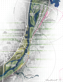
The project seeks to find the balancing point between culture and nature along the Wabash River in Lafayette, Indiana, which is currently underappreciated because of flooding, vacancy and disconnection. The design solution is an embodiment of cultural representation and technology of stormwater management in order to achieve ecological and social resilience. With potential for spontaneous use and dynamic programing, the site can transform into a sustainable infrastructure with a cultural identity that provides active waterfront experience.
Project Narrative
Time, space and culture have tremendous impacts on landscape. The power of them is so impressive that people would be amazed by things they can do to nature. In the meantime, it raises the question, in the field of contemporary landscape architecture, what is the balancing point between culture and nature? What gives a place its identity? How can we provide programs that fulfill pubic desires with minimum disturbance to existing natural system? Even further, I wonder if it is possible to use public infrastructure as an opportunity to solve these questions and restore the original ecological integrity. This project seeks answers to these questions at a specific site by analyzing and planning for the future of the Wabash River corridor in Lafayette, Indiana.
The Symptom
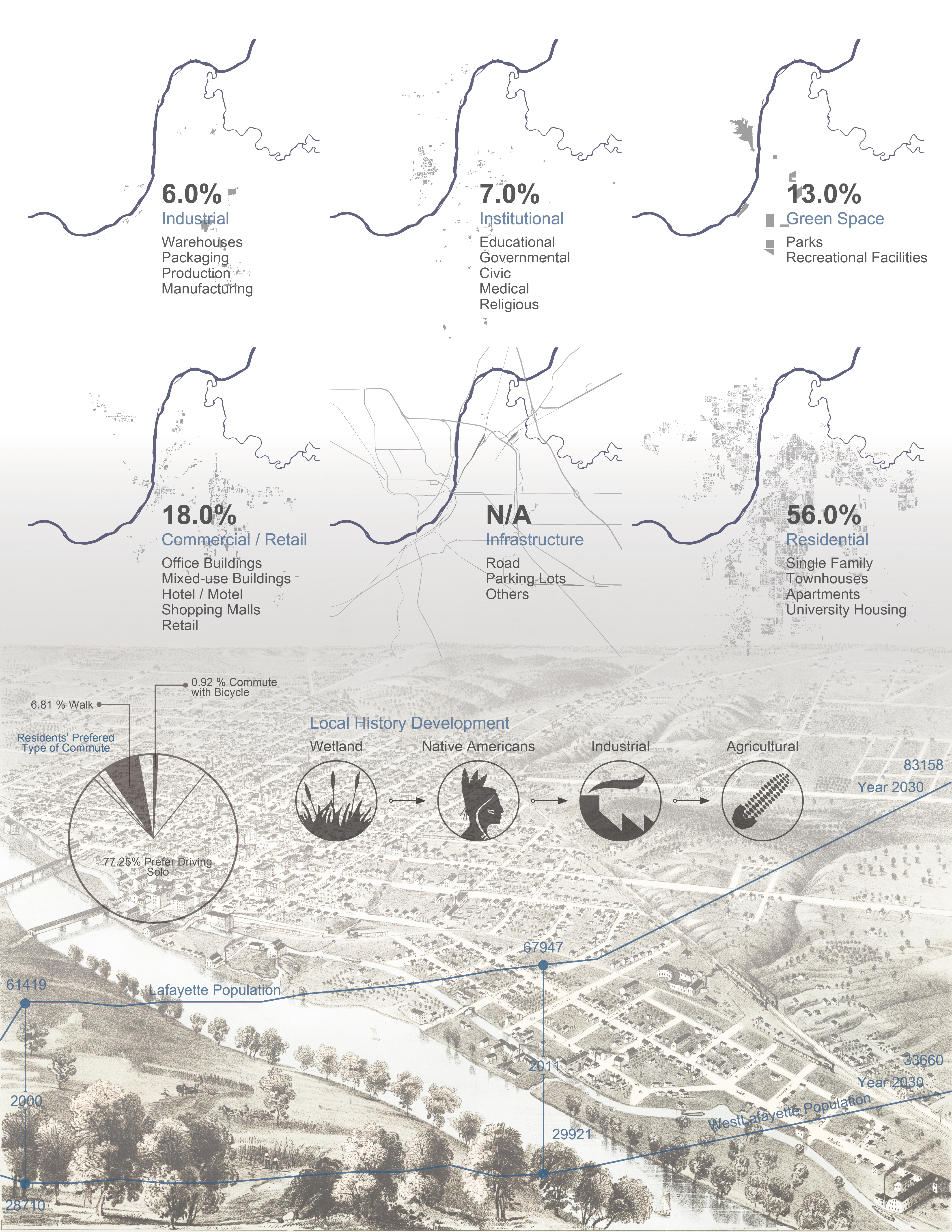
The current landscape condition has a negative impact to residents’ mobility and water related activities. With an industrial background and unhealthy developments in the past, vacant land, a poorly maintained golf course and over-managed parks are located along the river. The river should be a destination point in the region; a linkage between Lafayette and West Lafayette, but it serves contrarily. According to “Your Views of the Wabash River”, only 23% of the residents in the region would consider passive recreation along the river, and the reasons can be summarized as follows:
- Flooding / Current recreational facilities are built on the floodplain than can only be used at certain times of the year / 80% of the site is on the100 year floodplain while 20% of the site is on the 500 year floodplain.
- Vacancy / With a strong industrial background, vacant land remains after the removal of the factories / City of Lafayette had given up the maintenance of the golf course along the river because of flooding / Almost 70% of the land along the river is vacant.
- Isolation / The rail line running on the edge of the city is a major barrier to the site / There is not enough access connecting two cities (Lafayette & West Lafayette) to the site / About 50% of the population in the region see the river as a barrier, and almost 90% of them believe that there is potential to make the river a more accessible place of recreation.
- Limited Programs / Recreational facilities in Greater Lafayette are fairly spread across the city, but limited along the river / Existing parks along the river are poorly maintained, which are not attractive to residents.
- Lack of Understanding / The river itself is under appreciated / People don’t understand the history and cultural background of the river / Over 80% of people believe the river is the identity of the region while only 30% of them know the background of it.
- Disturbed Ecology / Storm water collecting from Happy Hollow Park is changing the route of the river which makes the flooding even worse / Invasive species have taken over the riverfront that decreases biodiversity and pushes out native species. Agricultural runoff is damaging the water and soil quality.
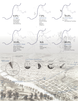
The History
The natural and cultural developing timeline of Lafayette can be condensed into four words: Wetland, Indian, Industrial, and Agricultural. In 1700’s, this region was inhabited by native people and was mostly wetland. In 1811, the Battle of Tippecanoe took place. In1825, City of Lafayette was founded by William Digby as an important station for water transportation. After that, the city embraced industrial development and constructed the Wabash and Erie Canal in the 1840’s. Today, Lafayette, a city built on river, has developed as a diversified community, with manufacturing, merchandising, education and agricultural production all contributing their share.
The Design
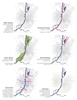
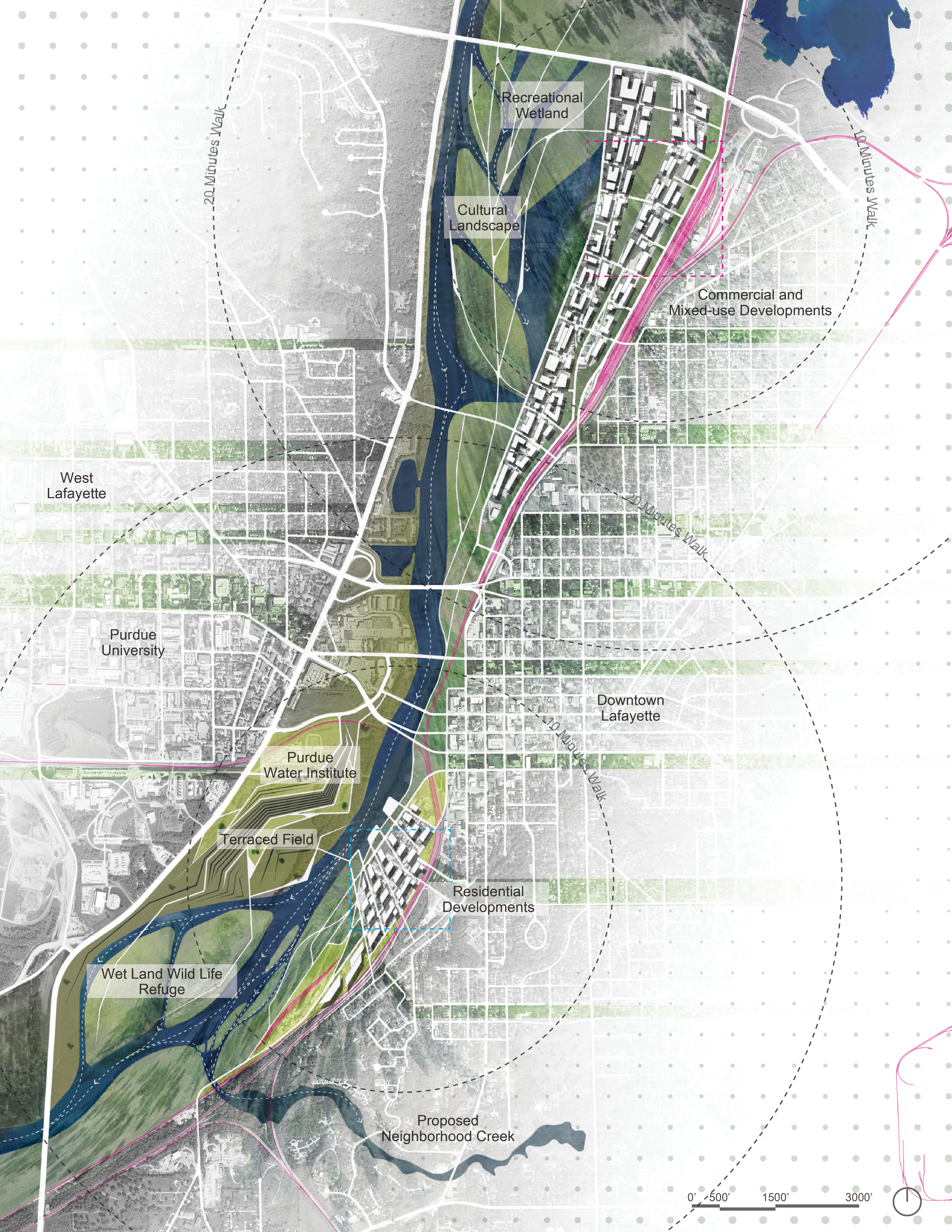
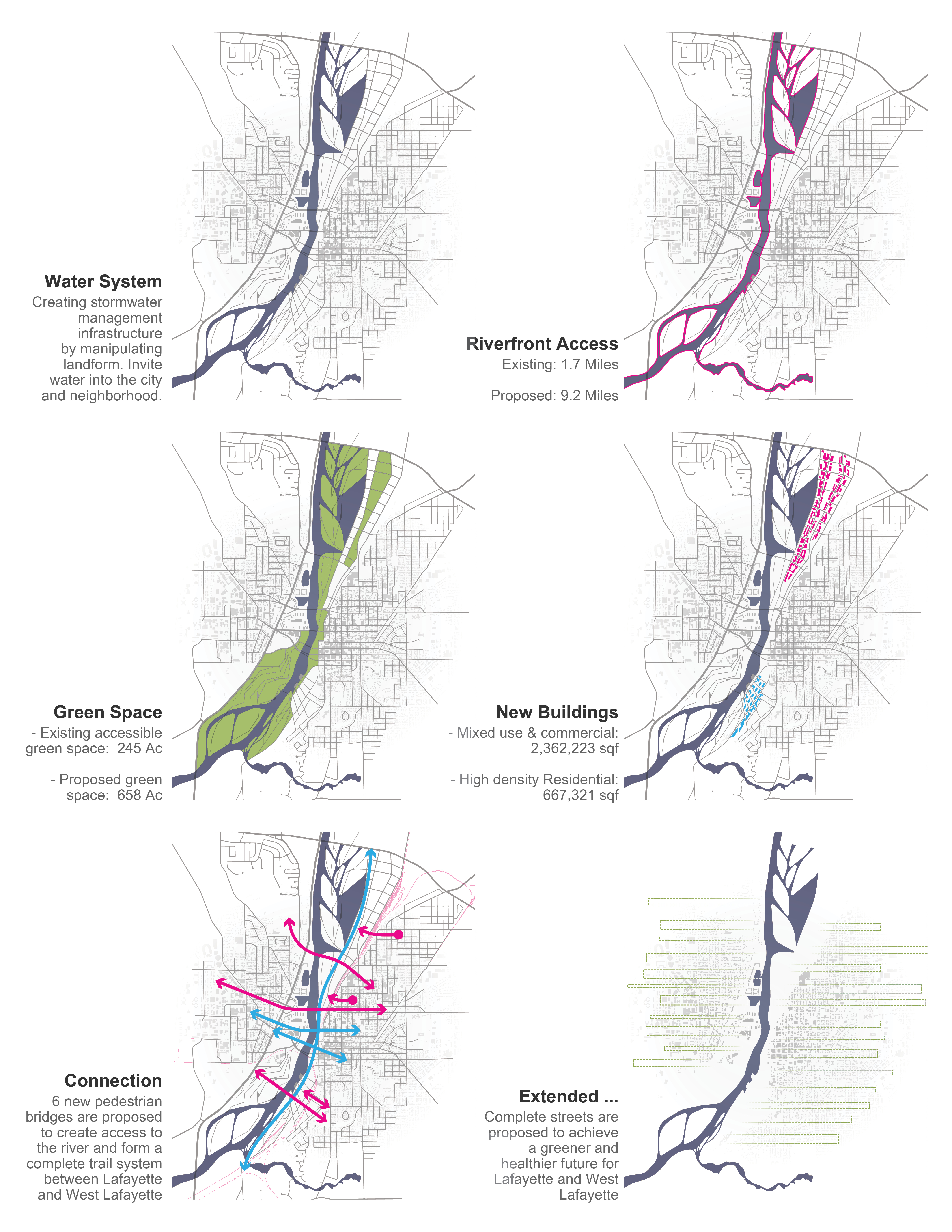
The general design of this project focused on the relationship between culture and nature. By studying reports about people’s view of the river, local geographic and demographic information, the concept of “cultural landscape serves as sustainable storm water management infrastructure” was formed. The inspiration of the design comes from the city’s history - the transportation tool Native Americans originally used on the river, and the main agricultural product of the city: corn. The morphological structure of the canoe and the matrix of the corn seed was taken, hybridized and re-conceptualized into revelatory shapes to create positive and negative landforms. It reroutes and collects water and serves as a buffer between the river and the city during flooding seasons. The plan provides a refuge for wetland plant and animal species. It also creates a platform for water related recreational actives. In this way, people have the opportunity to change their perspective about the river. The city of Lafayette will have its new cultural identity.
The Solution
The project takes advantage of the existing site condition and problems as opportunities for storm water management. It creates connections between cities. A water institute, recreational facilities, urban agriculture field, and commercial developments are also adapted into the project with site-specific design.
- Let It Flood – One River - Two Cities - Three Solutions / The final proposal is composed with a public infrastructure of water systems that brings ecological developments and cultural activities together. Instead of treating water as a major threat to the city and avoiding it, the plan welcomes water with three different landforms: mound, terrace, and creek. They all exist with the purpose of minimizing the harm of flooding, creating programs along the river, providing habitat for endangered species and making the water system visible to the public. People will have the opportunity to celebrate water and culture within the system of bridges, boardwalks, terraces and shelters even during flooding. Seasonal flooding also naturally fertilizes soil, makes urban agricultural production easier to establish.
- Let It Grow – Wetland Restoration, Urban Agriculture & Reforestation / The proposed ecological framework will adapt to the site condition over time. Bringing back wetlands that clean and improve overall water quality while providing refuge for animal species. Promoting Urban Agriculture in the neighborhood will establish healthy and sustainable food access to populations in needed.
- Let It Raise – Commercial Developments / Propose high density residential, commercial and mixed-use buildings along the river as the solution for the expanding of Purdue University and the increasing population in Greater Lafayette. The site itself becomes a district that creates job opportunities; a money generating landscape where people can shop, play and relax.
- Let Us Go – Create Connection / Reconnecting the site to cities. Several bridges are proposed on the river and above the railroad which connects two cities and Happy Hollow Park to form a complete trail system, making the riverfront more accessible to public.
- Let Us Learn – Water Related Education / With the development of the water system, people’s perspective about the river will be simultaneously changed. Visible water system provides people an opportunity to learn about the cultural background of the river. It also creates a platform for Purdue students to operate water related experiments.
- Let Us Play – Creating Program along the River / By studying local residents’ desire about the river, a system of site-specific designed programs with social context can be merged into the site. An oasis of urban recreation and healthy life style will be formed. Once again, the Wabash corridor will become the critical link between two cities with walkable and bike-able environments and year-round interests.
- Let Them Know - Create Identity, Educate the City / Using cultural landscape as an opportunity to increase public awareness about the natural and cultural history of the river / Create identity for the region.
Additional Project Credits
David Barbarash
Robert Sovinski
Drew Stangel
Taro Cai
Tippecanoe County GIS
United States Census Bureau
Stats Indiana
Wabash River Enhancement Corporation