


Award of Excellence
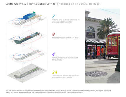
Lafitte Greenway + Revitalization Corridor | Linking New Orleans Neighborhoods
New Orleans
Design Workshop, Inc., Austin, TX & Aspen, CO
Client: City of New Orleans
 Close Me!
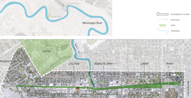
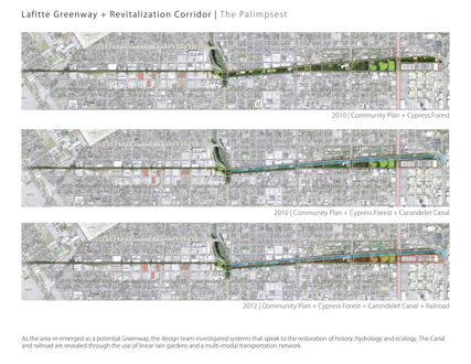
Site Plan. The Lafitte Greenway is a 3.1-mile long right-of-way that was once used for the transportation of goods along a rail corridor. It is currently envisioned as a vibrant multi-modal transportation corridor linking residents to the heart of the French Quarter.
Download Hi-Res ImageImage: Design Workshop
Image 1 of 16
 Close Me!
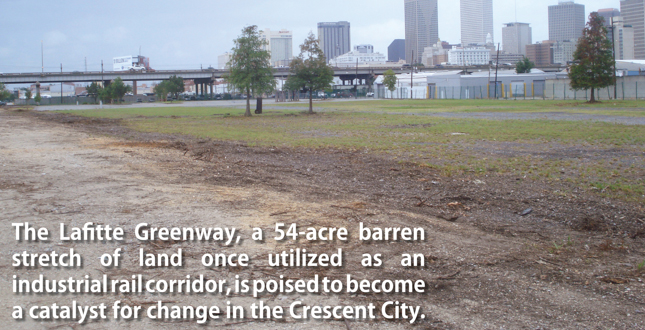
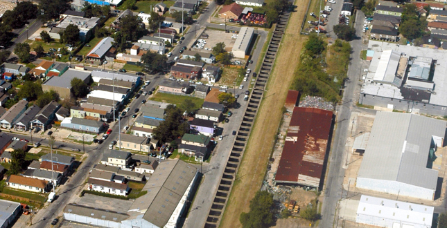
The Lafitte Greenway, a 54-acre barren stretch of land once used as an industrial rail corridor, is poised to become a catalyst for change in the Crescent City.
Download Hi-Res ImageImage: John Moon, Design Workshop
Image 2 of 16
 Close Me!
The brownfield site known as the Lafitte Greenway crosses seven historic New Orleans neighborhoods. While the Greenway currently acts as a divider of these neighborhoods, the design and revitalization strategy aims to unite these communities on a common ground.
Download Hi-Res ImageImage: Design Workshop
Image 3 of 16
 Close Me!
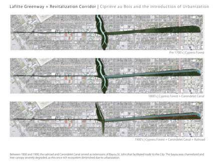
Between 1800 and 1900, the railroad and Carondelet Canal served as extensions of Bayou St. John that facilitated trade to the City. The bayou was channelized and tree canopy severely degraded, as this once rich ecosystem diminished due to urbanization.
Download Hi-Res ImageImage: Design Workshop
Image 4 of 16
 Close Me!
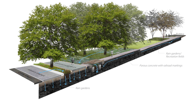
As the area re-emerged as a potential Greenway, the design team investigated systems that speak to the restoration of history, hydrology and ecology. The Canal and railroad are revealed through the use of linear rain gardens and a multi-modal transportation network.
Download Hi-Res ImageImage: Design Workshop
Image 5 of 16
 Close Me!
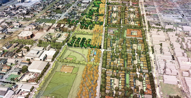
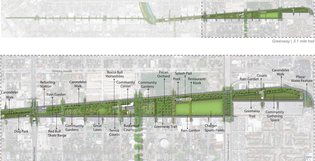
The Greenway trail weaves through fields, orchards, rain gardens, and recreational spaces, creating dynamic experiences across the site. The Greenway is transformed into a spine that not only connects neighborhoods, but provides distinction of design, function, context, and environmental responsibility.
Download Hi-Res ImageImage: Design Workshop
Image 6 of 16
 Close Me!
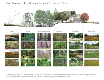
An in-depth analysis of the New Orleans landscape typologies shows the diverse ecotones that bisect the Corridor and Greenway. Subtle changes in elevation inform the planting design that determines which types of plant species will thrive in this complex environment.
Download Hi-Res ImageImage: Design Workshop
Image 7 of 16
 Close Me!
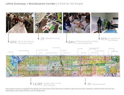
The immense amount of support for the design and construction of the Greenway resulted in a plan that was truly created by a collective effort from the City, stakeholders, community members, and the design team.
Download Hi-Res ImageImage: Design Workshop
Image 8 of 16
 Close Me!
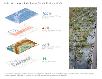
Research of the hydrology revealed that the Greenway is a high point and actually causes localized flooding of adjacent homes and businesses. Strategies to mitigate stormwater runoff include carving out recreation fields that double as natural stormwater reservoirs.
Download Hi-Res ImageImage: John Moon, Design Workshop
Image 9 of 16
 Close Me!
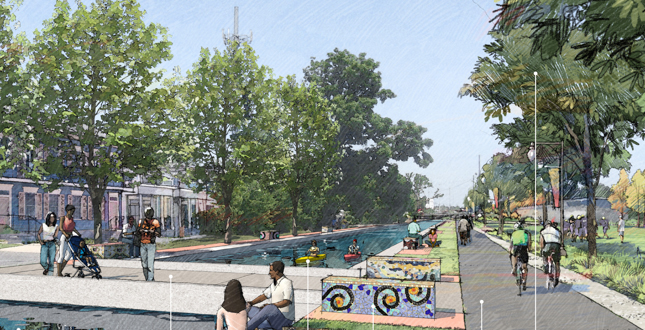
Portions of the historic canal are re-envisioned as recreational spaces and provide artistic opportunities to display ecological and historic processes. By capitalizing on existing infrastructures, the design achieves the goal of mitigating stormwater and increasing quality of life.
Download Hi-Res ImageImage: Design Workshop
Image 10 of 16
 Close Me!
The historic alignment of the Canal is retrofitted as a rain garden with 100-percent native plant material. The design achieves environmental sustainability by restoring the native ecology and increasing habitat for wildlife, while providing essential recreation space for the community.
Download Hi-Res ImageImage: Design Workshop
Image 11 of 16
 Close Me!
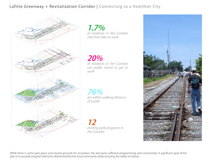
While there is some park space and neutral grounds for recreation, the area lacks sufficient programming and connectivity. A significant goal of the plan is to provide program elements determined by the local community while ensuring the safety of visitors.
Download Hi-Res ImageImage: John Moon, Design Workshop
Image 12 of 16
 Close Me!
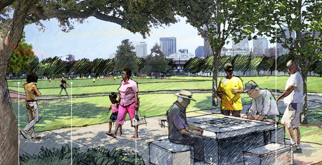
Programmatic elements identified by Corridor residents are integrated into the park, achieving access to health and wellness. Open spaces are passively ventilated, providing areas of human comfort while also reducing vulnerability to environmental stresses.
Download Hi-Res ImageImage: Design Workshop
Image 13 of 16
 Close Me!
The rich history and mix of neighborhood identities are reflected in the design strategy for the Greenway and recommendations of the plan. Instead of acting as a barrier of neighborhoods, the Greenway seeks to unite residents and foster community interaction.
Download Hi-Res ImageImage: Design Workshop
Image 14 of 16
 Close Me!
Transforming the existing City-owned building into an open-air pavilion with community gardens and rainwater collection system offers new solutions for existing structures. Incorporating historic buildings within the Greenway achieves economic sustainability and provides meaningful gathering space for community events.
Download Hi-Res ImageImage: Design Workshop
Image 15 of 16
 Close Me!
The plan responds to the needs of the community and replenishes the barren stretch of land into a lush Greenway. Most importantly, this plan capitalizes on underutilized public space, bringing the citizens of New Orleans together on a common ground.
Download Hi-Res ImageImage: Design Workshop
Image 16 of 16
Project Statement
As one of the first revitalization projects since the devastation of 2005's Hurricane Katrina, the 3.1-mile linear Lafitte Greenway will become a vibrant, multi-modal transportation corridor linking residents to the heart of New Orleans, Louisiana. The landscape architect led a multi-disciplinary effort—incorporating public input, synthesizing many measurable objectives and working across a range of scales—to transform an old industrial rail corridor into a celebrated Greenway.
Project Narrative
—2013 Professional Awards Jury
The Site
The 54-acre Lafitte Greenway was once a former shipping canal and railroad right-of-way that connected the historic French Quarter to Bayou St. John and Lake Pontchartrain. The Lafitte Corridor is a 1,375-acre district that includes the Lafitte Greenway and a rich mix of residential, retail and industrial uses. The Corridor contains 13,583 residents and traverses a cross-section of the City reflecting 200-year settlement patterns ranging from the colonial-era settlement of the Vieux Carré to the mid-twentieth-century suburban neighborhood of Mid-City. Presently, this district contains a spectrum of socioeconomic conditions and racial compositions, creating a challenging context for community engagement.
The Challenge
The City of New Orleans retained a multi-disciplinary team to complete four comprehensive tasks: 1) the Lafitte Greenway Master Plan, 2) the Lafitte Corridor Revitalization Plan 3) construction documents for the Greenway and an 4) Operations and Maintenance Plan. This extraordinary effort required the design team to assess the role of the Greenway within the City as a whole, identify a revitalization strategy for the entire Corridor and create a detailed design for the implementation of the Greenway. The consultant team planned and designed at these three distinct scales but also advised on the important management, budget and operations of the Greenway.
Process
In planning and designing the Lafitte Greenway, the consultant team followed a rigorous process to ensure that the work resulted in extraordinary outcomes with measurable results. Understanding critical questions through five overarching design principles—History, Environment, Art, Community and Economics—was paramount to creating a project that was sustainable for the long term. These questions helped the team form goals that were Specific, Measurable, Action-oriented, Realistic and Time-based (SMART). For each SMART goal, at least one metric with an associated baseline existing condition was established by which success could be measured. Best practices, case studies and research from sources such as LEED® ND and American Forests were compared to establish benchmarks for each metric. This process resulted in a set of strategies that has been integrated into the design of the Greenway and the revitalization recommendations for the Corridor.
Garnering Community Support
The community engagement approach was inclusive of all segments of the New Orleans community, with specific focus on neighborhoods and organizations within the Corridor. The overall strategy involved a series of three public meetings, eight public presentations, over 75 stakeholder meetings, online surveys and Chip Game events with 12 constituent groups. The Chip Game was a collaborative exercise allowing the community to suggest types of park facilities and landscape treatments appropriate to the Greenway. The foundation of the game was developed through recommendations for park programming based on the Corridor's population of 13,583 residents. Chip Game results allowed the consultant team to develop a local park program standard which could be used as a guide for future park planning in the city. The Chip Game was played by various stakeholder groups of the Lafitte Greenway including the Friends of Lafitte Corridor, community members, and students from the local high school and elementary school.
Envisioning the Greenway
The overall design concept draws upon principles of historic ecology and builds upon the rich layers of the site's history while also taking into account community input and previous plans. The historic alignment of Carondelet Canal is marked by a mile-long bosque of bald cypress trees evocative of the Cipriére au Bois (Cypress Forest) that once covered the site. Within this grove is an ephemeral rain garden filled with stunning displays of native Louisiana iris, New Orleans' city flower. Rust stained bands of paving trace the location of train tracks once traversing the site. Plantings reflect the natural vegetation patterns of south Louisiana with swamp species that transition to bottomland hardwoods and upland species as the Greenway rises to the Metairie Ridge and natural level of the river.
The design creates synergies between existing community facilities and designed elements of the Greenway, providing open space for formal and informal activities. Geo-referencing of 18th century maps identified the location of the Carondelet Walk, a historic tow path of the Carondelet Canal. The new Carondelet Walk of crushed, recycled brick provides a secondary path within the park and a grand promenade, much as the original had done 200 years before. In addition to a fine walking surface, according to New Orleans tradition, a line of red brick dust wards away enemies and evil spirits! A new community garden is placed where the Lafitte community garden, once the longest continuously operated community garden in America, was located.
Sustainable Principles
The design for the Greenway incorporates sustainable design through green stormwater infrastructure, native plantings, adaptive re-use of existing buildings and the reduction of impervious surface. The Lafitte Greenway will be one of the first projects in New Orleans that creates measurable outcomes that aim to lessen the effects of urban heat island and increase stormwater management capacity. Specifically, the restoration of the natural edge conditions of Bayou St. John will encourage fish and wildlife habitat, support biodiversity and increase water quality. The reconfigured community space will provide a hill and amphitheater for local community festivals such as Bayou Boogaloo.
The Revitalization Plan
In addition, the landscape architects were called upon to lead an economic revitalization strategy for the surrounding Corridor. Strategies were developed for Safe Routes to School, for a dramatic expansion of the community gardening program which will exceed LEED® standards, and for the creation of nodal mixed-use development at major intersections. The landscape architects worked to ensure the Greenway was zoned as open space, thus avoiding use of the land for other purposes. A set of form-based development standards will supplement the City's new zoning ordinance to ensure orderly infill in response to this new civic asset. A Corridor-wide strategy for stormwater management will also address the district's historic flooding problems.
Implementing the Vision
As the Greenway will employ the most extensive use of green infrastructure and native plant material in the City's history, it is not sufficient to merely build the Greenway; there must also be a strategy for its operation and management. New Orleans is unique among American cities in that park operations are divided between two entities: Parks and Parkways and the New Orleans Recreational Development Commission. It was necessary, therefore, for the landscape architect to prepare a maintenance budget and protocols as well as to negotiate the management of the Greenway between these two entities. In addition, although it is estimated to cost $35 million to construct the Greenway, these two entities have only $6.5 million dollars available for construction. Thus, in a severe climate of fiscal austerity, the landscape architect was also called upon to develop a partnership program in which various civic groups could develop and fund portions of the project.
Measuring Success
Working within a holistic, sustainable design framework, the landscape architects created a system of performance metrics, baseline measurements and benchmarks in the categories of history, environment, community, economics and art which far exceed those of LEED® or Sustainable Sites. A number of positive outcomes will be achieved. For example, restoring the historic Cypress tree canopy will result in an increase from three-percent to 46-percent tree canopy coverage. One-hundred percent of the storm water falling on-site during the 10-year storm will be captured without the use of pipes, thus lessening the load on New Orleans' already overtaxed stormwater system and reducing subsidence. Finally, through the use of 100-percent native plant material, wildlife and bird populations are projected to quadruple.
Future
The plan successfully responds to the needs of adjacent communities and it replenishes the barren stretch of land into a lush, vibrant Greenway. Most importantly, this plan gives back to the City of New Orleans and capitalizes on underutilized public space, bringing the citizens of New Orleans together on a common ground. By taking a comprehensive approach to analysis and implementing a robust planning process, the Lafitte Greenway considers all voices of the people and breathes life into an iconic Greenway.
Project Resources
Design Workshop Team Members
Kurt Culbertson, FASLA, Lead Designer & Landscape Architecture
Rebecca Leonard
Steven Spears, ASLA
Phillip Koske
Stacie Jagger
Mary Martinich, Assoc. ASLA
David Farber
Alex Ramirez, Assoc. ASLA
Brianna Pacheco
Kelan Smith
Jessie Young, ASLA
Ed Krafcik, Assoc. ASLA
Paul Squadrito
Marcus Pulsipher
Nick Aceto
Michael Budge
Jom Naknakorn
Nino Pero
Natalie Grillo
Alison Kelly, ASLA
Consultant Team Applied Ecological Services
Threefold
Elkiins, P.I.C
Eskew Dumez Ripple
Greenplay
Walter Kulash
Chris Davala
Bright Moments
Michael Willis Architects
RCLCO