


Honor Award
City/Park Hybridized
SWA Group, Laguna Beach, CA
Client: Changsha FuRong Urban Construction Investment Company
 Close Me!
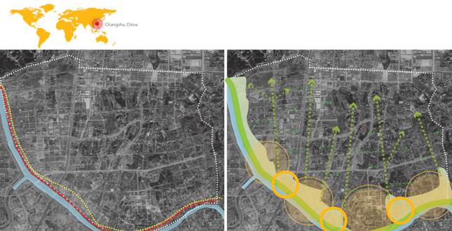
Context, levee as a barrier, & connecting a city to its river.
Download Hi-Res ImageImage: SWA Group
Image 1 of 16
 Close Me!
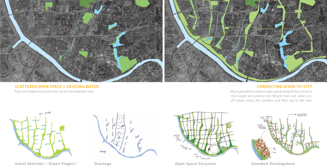
The existing open space network was disconnected and scattered throughout the city.
Download Hi-Res ImageImage: SWA Group
Image 2 of 16
 Close Me!
A new Changsha ecocity riverfront, where city becomes park and park becomes city.
Download Hi-Res ImageImage: SWA Group
Image 4 of 16
 Close Me!
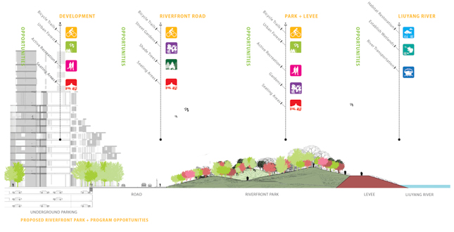
Existing diagrammatic section + proposed river front extension.
Download Hi-Res ImageImage: SWA Group
Image 5 of 16
 Close Me!
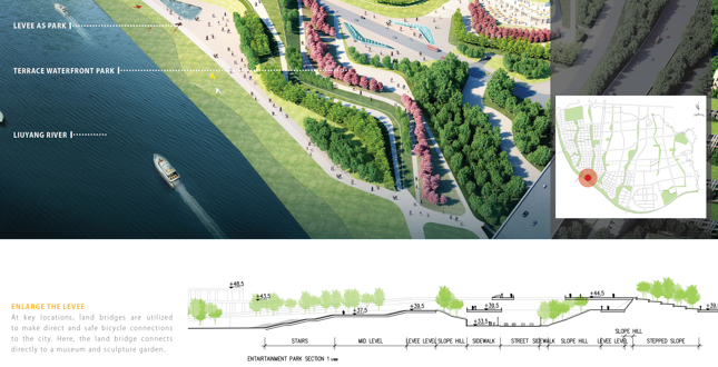
Widen the levee across a frontage road with a land bridge.
Download Hi-Res ImageImage: SWA Group
Image 6 of 16
 Close Me!
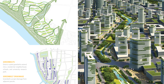
Extend the park into the city using greenbelt corridors.
Download Hi-Res ImageImage: SWA Group
Image 7 of 16
 Close Me!
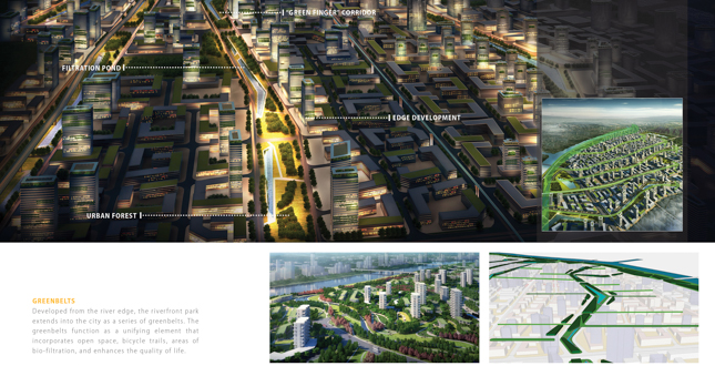
Urban greenbelts define city structure, safely connect districts, and function as urban filters.
Download Hi-Res ImageImage: SWA Group
Image 8 of 16
 Close Me!
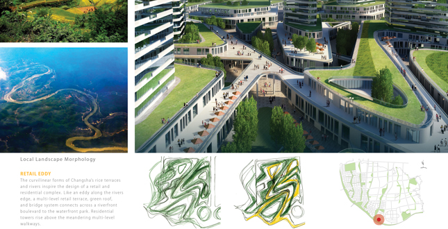
A multi-layered system of pedestrian terraces, residential towers, & gardens are seamlessly integrated.
Download Hi-Res ImageImage: SWA Group
Image 9 of 16
 Close Me!
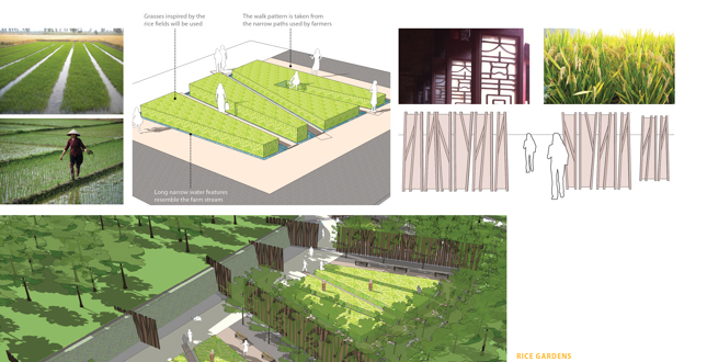
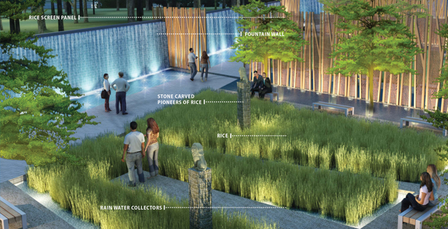
The story of rice is integrated into the park fabric.
Download Hi-Res ImageImage: SWA Group
Image 11 of 16
 Close Me!
Rice gardens, celebrating the agricultural heritage of changsha, are carved from the waterfront forest.
Download Hi-Res ImageImage: SWA Group
Image 12 of 16
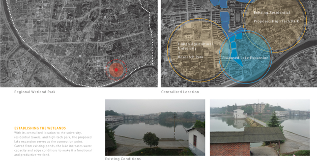 Close Me!
The existing ponds are transformed into a centralized lake that will collect and treat urban runoff.
Download Hi-Res ImageImage: SWA Group
Image 13 of 16
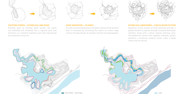 Close Me!
The pond edge is increased to create edge variation, microtopography, & a resilient & functional wetland.
Download Hi-Res ImageImage: SWA Group
Image 14 of 16
 Close Me!
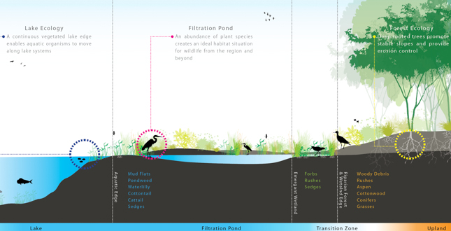
Understanding the effects & functions of river, wetland, & forest ecologies.
Download Hi-Res ImageImage: SWA Group
Image 15 of 16
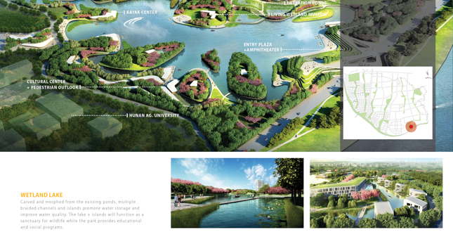 Close Me!
An existing lake is reshaped to establish wetlands & incorporate recreational, & educational programs.
Download Hi-Res ImageImage: SWA Group
Image 16 of 16
Project Statement
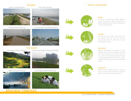
The 10 kilometer Changsha Liuyang River Waterfront hybridizes city and park into a multi-functional landscape tapestry. Disconnected by a levee, Changsha is reconnected to its cultural past through a comprehensive strategy. The existing levee is widened into an urban forest, greenbelts extend into the city, adjacent districts are integrated into the waterfront landscape, and new wetlands are established from an existing lake.
Project Narrative
—2013 Professional Awards Jury
An unfortunate outgrowth of china's rapid urbanization has been the large scale loss of its natural systems and cultural heritage. These systems served as a framework for living and a buffer against disaster; the flooding of entire regions and the destruction of property, lives, and a way of life. A new model of riverfront development is necessary, re-connecting cities and its people to its cultural heritage.
Innovation
Reaching back into diverse land uses and modifying their structure, the Changsha river park marries landform and architecture, blurring the river and city edge. Entire districts take on the character of the river, where shopping development twists and turns like the meandering river currents, and new wetland parks are established as urban bio-filtration and wildlife enhancement. An extension of a comprehensive greenbelt system, the waterfront hybridizes city and park, reconnecting the city to its river, and a people to its culture.
Culture - Living on the Water
The channeling and consolidation of river systems throughout southern China has weakened both nature and local culture. Throughout its history, the Changsha region has been widely known as a water-based society, one where daily life revolved around the water's edge. Transportation, food, and daily gossip originated along the river. Families congregated and socialized under the cool shade and welcoming branches of the river Willow trees. The ebb and flow of seasonal river water levels connected the people to the rhythms of nature. But increased flooding led to the loss of life, and so the draconian separation of city and river was implemented as a massive levee system, condensing and controlling and increasingly volatile and destructive force. But the loss and separation of the city through the constructed levee system has led to the loss of much more. Thus, the reconnection of a city to its river, both physically and culturally, has become a central focus of the Changsha Liuyang River design.
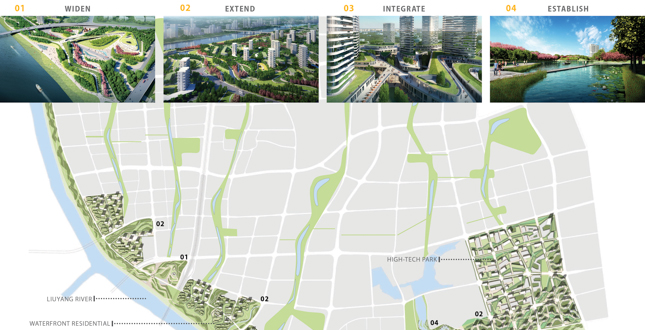
Four Strategies
The Changsha River Liuyang Waterfront connects new urban areas to its historic river culture. Conceived as a woven fabric of green threads, the riverfront park expands and strengthens the existing 10 kilometer levee system as sculpted terraces that reach back into the city edge. Four strategies are utilized; firstly, the levee is made large, adding additional terraces alongadding additional terraces along the city edge and widening its breadth, providing a more gradual topographical transition to development. Secondly, a series of 'Green Fingers' extend from the waterfront into the new city, acting as both drainage filter for runoff and a bicycle transportation network. Thirdly, adjacent development is designed to infuse landscape and architecture, bringing the value of the park literally into the urban edge. Curving forms build upon the nine curves of the adjacent Liuyang River, allowing for a layered pedestrian and green terrace system, integrated with base retail and residential/office towers. And finally, new wetlands are established that serve as collection points for urban runoff, bio-filtration, ecological habitat creation, and recreational resources.
Widen the Levee
As a physical and visual barrier to the city, enlarging the levee at first seems contrary to conventional thinking. However, increasing its width allows for the levee to act more as a regional park, while providing an easier terraced transition to the land uses behind.
A wider levee allows for the planting of substantial forest. The forest not only incorporates a variety of recreational activities and 'hidden gardens' within its meadows, but provides a massive carbon sequestration sink for a growing metropolis. A series of terraces are developed to step the levee down to the city, in some cases integrating with architecture as a kind of 'park/city' hybrid.
Extend Green Fingers
The second step of re-connection involves a broader urban strategy; designing a series of 'Green Fingers' at a large scale that work within the established city grid. Ranging in width from 50 to 200 meters, the greenbelts extend into the city fabric and provide drainage down to the river, a bicycle network, reduced reliance on the automobile, bio-filtration, and forested areas for carbon sequestration. Schools and shopping areas are planned along its edges, allowing for greater walking and bicycle connectivity to residential neighborhoods.
Integrate Architecture
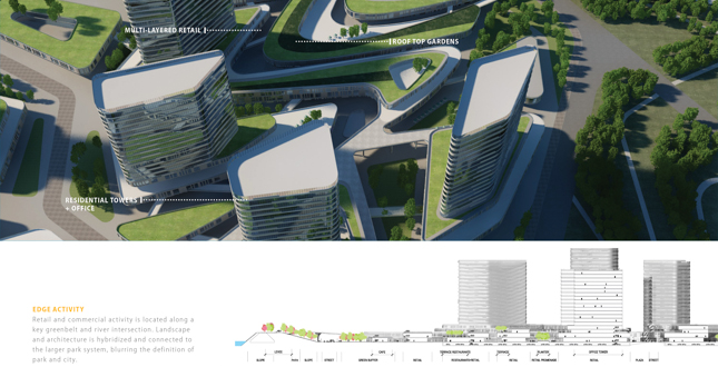
A green architecture is designed that blurs traditional boundaries, incorporating meandering pedestrian 'canyons' in retail areas and land bridges connecting the main park promenade to the district beyond. A layered pedestrian and green terrace system, integrated with base retail and residential/office towers, moves like the current of the river, around towers and embracing internal courtyards. Envisioned as a multi-story garden, the Retail Park urbanizes the waterfront experience, as skywalks bridge city towers and landscape terraces together. Walks twist and turn to reveal surprises, leading to hidden courtyards or expansive rooftop gardens. Land bridges connect across boulevards to tie residential, retail, office, university, and the more urban 'green fingers' into the river park. Recalling the days when villages nestled beneath the Willowed waterside, the park and city merge along this new district edge.
Establish Wetlands
Carved from an existing lake, the Wetland Park expands the water area and edge conditions to increase its cleansing capacity, enhance wildlife habitat, and recreational resource opportunities. Multiple islands and bays create a tapestry of river grass, forest, and berms. Boardwalks and trails link together a University Research Center, Living Wetlands Museum, cafe, tea pavilions, resort, and Kayak Center. Water quality is improved via a series of purification wetlands and ecological islands, providing a bird wildlife refuge, fish ponds, and testing ground for continued river research. Bird-watch platforms, Metasequoia islands and perch pole zones provide both people and birds an adequate resting place amongst the new wetlands.
Blur the Boundaries
Around the world, cities have worked hard to re-connect to their waterfronts. Parks, trails, plazas and promenades have all been utilized in various degrees as solutions to a universal problem. However, increased urbanization and waterfront development pressures demand a more comprehensive approach; one that moves beyond a mere 'greening of the edge'. At Changsha, such an approach is explored- one that challenges conventions to re-imagine the very definition of architecture, landscape, and infrastructure. Blurring the boundaries while sharpening the connections, Changsha reconnects a city and its people to their river and cultural heritage.
Project Resources
Lead Designer
Sean O'Malley, ASLA
Landscape Architect of Record
SWA Group
Additional Project Credits
Xiao Zheng
Xue Ling
Miguel Rivera, Assoc. ASLA
Andrew Watkins
Pavel Petrov
Robert De Miguel