


HOnor Award
Interactive Ecoregional Management Plan (I.E.M.P)
Shannon Nowell, Student ASLA, California State Polytechnic University, Pomona
Faculty Advisors: Claire Latane, ASLA, Andrew Wilcox, ASLA and Keiji Uesugi, ASLA
 Close Me!
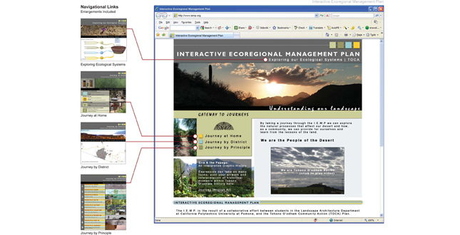
Upon accessing the home page, the IEMP opens to the index page. When visitors hover over “Gateway to Journeys” a drop-down “Journey” navigation appears allowing visitors to explore the site at three different levels.
Download Hi-Res ImagePhoto: Shannon Nowell
Photo 1 of 11
 Close Me!
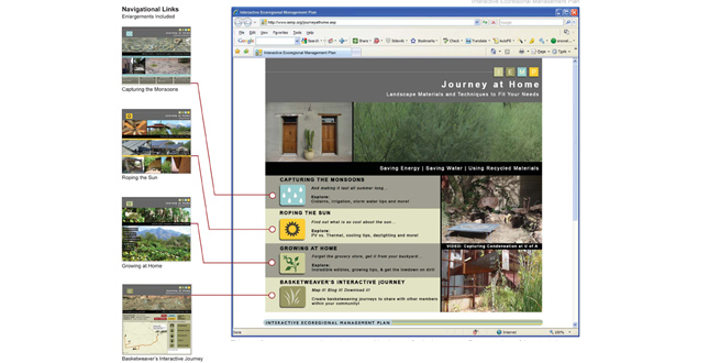
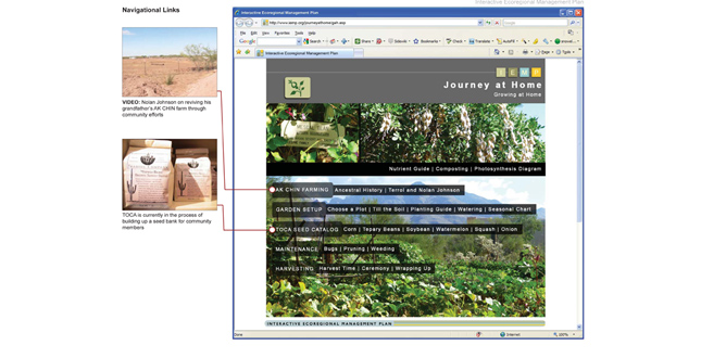
This page focuses on conservation techniques and landscapes for the homeowner. Demonstrations of these techniques and case studies are provided. The website encourages exploration of these techniques through instructional support and interactive components, such as the Basketweaver’s Interactive Journey.
Download Hi-Res ImagePhoto: Shannon Nowell
Photo 2 of 11
 Close Me!
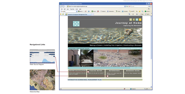
Monsoon rains are an intrinsic part of traditional Tohono O’odham practices; however, historically water policy has affected the way it is distributed. This webpage discusses stormwater management techniques, and provides education resources to assist in the self-sufficiency of this resource.
Download Hi-Res ImagePhoto: Shannon Nowell
Photo 3 of 11
 Close Me!
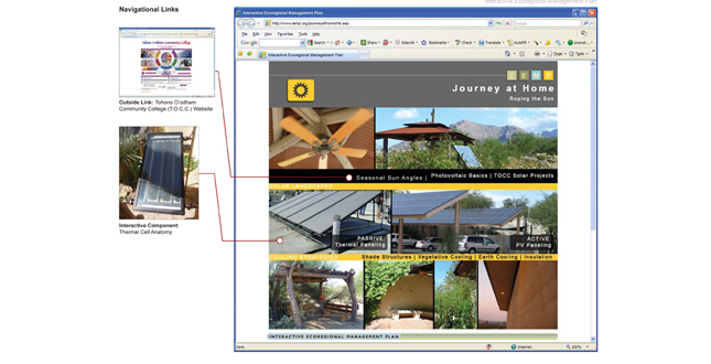
Vast stretches of sunbathed landscape are opportunities to harness solar energy; and yet, forty percent of dwellings within the Nation are without electricity. This page gives examples of passive and active techniques, plus cooling strategies to mitigate summer temperatures.
Download Hi-Res ImagePhoto: Shannon Nowell
Photo 4 of 11
 Close Me!
Many efforts are already in place to educate the nation’s youth about traditional agricultural practices. This page consolidates current and traditional Tohono O’odham agricultural practices into a simple sequence and provides support through educational resources.
Download Hi-Res ImagePhoto: Shannon Nowell
Photo 5 of 11
 Close Me!
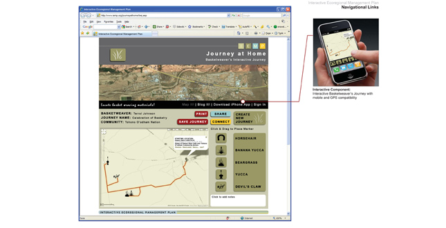
Locating basket weaving materials is an issue within the Nation due to factors such as Border Patrol, development, and more. Creating a journey allows the user to map these materials and share the route with other members of their community.
Download Hi-Res ImagePhoto: Shannon Nowell
Photo 6 of 11
 Close Me!
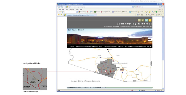
Examining the features of the landscape at the district level allow for a broader view of ecological interactions within. Additionally, a side-by-side comparison of Tohono O’odham Nation’s geographical features by district may assist in environmental policy efforts.
Download Hi-Res ImagePhoto: Shannon Nowell
Photo 7 of 11
 Close Me!
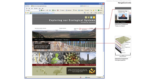
Visitors can use these drop-down navigation menus to explore the Sonoran Desert landscape and issues applicable to Tohono O’odham Nation. Each section focuses on areas directly related to features within the Nation, such as “Why are the rocks red?”
Download Hi-Res ImagePhoto: Shannon Nowell
Photo 8 of 11
 Close Me!
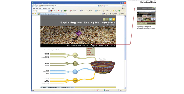
This page allows the visitor to explore terrestrial systems by answering popular questions that relate to cultural practices. Explore the flora by making a Cholla bud salad, or learn about the fauna by listening to an old Tohono O’odham tale.
Download Hi-Res ImagePhoto: Shannon Nowell
Photo 9 of 11
 Close Me!
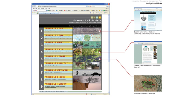
TOCA’s program goals and strategies include creating a sustainable community. Therefore, nine sustainable design principles were developed to help define sustainable techniques and practices applicable to Tohono O’odham Nation and its landscape; thus, supporting a community of problem-solvers.
Download Hi-Res ImagePhoto: Shannon Nowell
Photo 10 of 11
 Close Me!
In compliance with goals from the Tohono O’odham Community Action plan, these principles guide sustainable planning in the context of the Nation’s culture and beliefs. Additionally, the resources available on this website, such as Exploring Ecological Systems, support these principles.
Download Hi-Res ImagePhoto: Shannon Nowell
Photo 11 of 11
Project Statement
The Interactive Ecoregional Management Plan (I.E.M.P.) is an interactive tool to assist Tohono O’odham Nation community members in the exploration of historical and cultural attributes within their Sonoran desert landscape. This website addresses cultural stressors by creating journeys of opportunity into empowerment and problem-solving for various types of visitors. Features of the website promote physical and social activities outside of the website while being an interactive educational resource for sustainable land design principles and ecology.
Project Narrative
Context
The Interactive Ecoregional Management Plan (I.E.M.P.) is a collaborative journey through process and resilience for Tohono O’odham Nation. Located along the border of Arizona and Mexico, Tohono O’odham Nation faces unique issues within their community. Illegal border crossings leave abandoned vehicles and waste within their Native American landscape as the border itself creates a barrier between Mexican-born and American-born tribe members. However, no issue is greater than the diabetes epidemic that prohibits the growth of this nation culturally and physically. For them, it is not a matter of “if” they are going to develop Type II diabetes; it’s a matter of “when.”
As a two-part process, this project first analyzed historical paths and emergent behaviors of Tohono O’odham Nation. This was done through site visitation, interviews with elders, basketweavers and storytellers, landscape photography, video, and analytical research. It was discovered that the mechanism of change from a culture of agriculture and independence to one of dependence and diabetes was the damming of the Gila River. This left insufficient water downstream to support the agricultural efforts meant to feed the Papago people, predecessors of Tohono O’odham Nation. Therefore, food supplement programs by the United States government were implemented to support the starving nation. However, due to a genetic predisposition in the way their bodies respond to insulin, the processed foods distributed in the government supplement programs led to a community with the highest rate of Type II diabetes in the United States. Seventy percent of Tohono O’odham nation has been diagnosed with this form of diabetes. In a culture where tradition is passed from elder to youth through storytelling it is nearly impossible to support these cultural traditions when there are not any elders left that know these stories. In the words of Terrol Johnson, a member of Tohono O’odham Nation, “This path of disempowerment led us to a loss of identity.”
Implementation and Resilience
The I.E.M.P. addresses improving the resilience effort of Tohono O’odham Nation’s cultural traditions and identity. Within the stories and cultural beliefs of Tohono O’odham Nation is a strong reference to elements within the landscape. In fact, their stories personify these elements as a way of relating to the youth of the nation. However, the significance of these traditions is somewhat lost to a generation that has never worked the land, lives off of government supplement programs, and is burdened with obesity and diabetes. The Interactive Ecoregional Management Plan is part of the resilience effort already in place to improve the Nation’s connection with their land and cultural traditions.
The I.E.M.P. is a website networked with the existing community website hosted by the Tohono O’odham Community Action plan (T.O.C.A.) However, the I.E.M.P. website differs from this website by using technology to teach attributes and characteristics of the landscape that in the past would have traditionally been passed on from generation to generation by working the land. Using this technological approach is appropriate because of the current trends accepted by the local community college, community programs, and federal technology grants received by Tohono O’odham Nation, such as new computers available for their Information Technology degree and certificate programs.
Exploration as Process
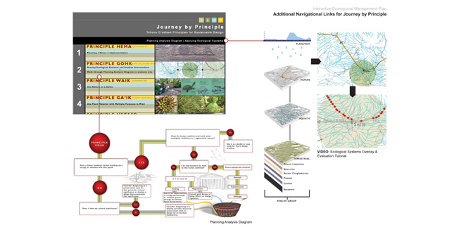
There are multiple ways to explore the landscape through this website. Although the information is presented in an educational format on the website, activities prompted by the website encourage interaction within their desert landscape. For instance, basketweavers can map where traditional materials for basket making are located within the landscape. This can then be shared with other members of the community so that they may also experience this journey. The information is presented in the form of “journeys” which is relative to their cultural practices. In the Tohono O’odham language, the word “Himdag” represents a journey, or what they call their “lifeways.” To embrace the Himdag is to walk in balance- alone, with others, with nature and with the creator (Baboquiveri Mountain.) They can explore storm water management or passive cooling techniques for their home by taking the “Journey by Home” navigation. The “Journey by Principle” path is relative to some of the goals presented by the Tohono O’odham Community Action plan by addressing sustainable design. It provides nine principles as guides when approaching potential design solutions. These principles are presented in their native language and remain consistent with the exploration, or “journey”, concept within the rest of the website. Additionally, a video is provided demonstrating how information from the Exploring Ecological Systems portion of the website may be used (overlaid) to make planning decisions. In this way, the visitor can follow the systematic approaches a landscape architect may take instead of having to rely solely on personnel outside the Nation.
Supplemental to these journeys are opportunities for expression through art and exploration of the ecological systems relative to their natural environment and biome. Understanding ecological systems encourages curiosity to explore these conditions within the landscape. In fact, the I.E.M.P. presents this information in the form of questions visitors may experience, such as “Why are the rocks red?” The “Journey through Art” path is a programmatic element used to jumpstart the posting of artwork that may express the strong opinions of historical injustices relevant to the experiences within Tohono O’odham Nation. This feature was added because analysis indicated that there was a need for a positive outlet in this direction.
Empowerment
The analysis was an imperative step in this project because it outlined the needs of the nation that may have been overlooked. Tohono O’odham Nation community members do not need another person to create a solution for them- they want to do it on their own in order to reestablish a sense of identity. Therefore, they needed a project that was a tool to implement their ideas. The Interactive Ecoregional Management Plan (I.E.M.P.) is a tool that allows then to see through the eyes of a landscape architect, rediscover their heritage, and understand what it means to be the “People of the Desert.”
Additional Project Credits
The Faculty of the Landscape Architecture Department at Cal Poly Pomona University