

«previous pageANALYSIS & PLANNING CATEGORY
Switching Trajectories in the Rhine Delta
Student Affiliate ASLA
Swiss Federal Institute of Technology, Zurich, Switzerland
faculty advisors: Christophe Girot and Sebastien Marot
Project Statement
The current watershed problematic in Switzerland asks for a comprehensive landscape design that integrates a broad palette of natural and urban factors. This project is addressing actual flooding risks and sedimentation problems in the Rhine River delta area. It is taken as an opportunity to generate a structural approach to large-scale landscape design that balances a minimal use of existing resources with new meanings to emerge.
Project Narrative
Project's Objectives and Goals
Switching Trajectories is about actively preparing the territory for the future switching of the Rhine River in a place and a time where it can no longer happen in a natural way. While giving the water a new path and, more importantly, space, the project aims to address the flooding risks and sedimentation problems of the delta area. Since development pressures threaten to deplete and diminish the site's resources and special characteristics, the problematic is turned into an opportunity to re-interpret the existing and to offer a new spatial vision for the site as a whole. The objective is thus broadened to the creation of multiple landscapes that negotiate between living, water and land, and in which infrastructure is operative and intertwined.
Data Collection and Analysis
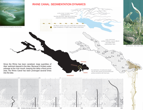
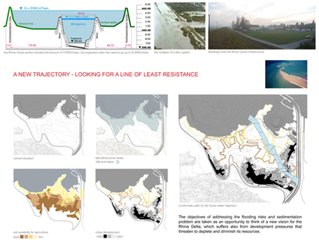
On the one hand the project draws on quite scientific and rational resources such as hydrology and infrastructure. Investigation of how the river has been canalized and narrowed down to its minimum space shed light on the isolation of the Rhine Delta over a century ago by 'corrected' river profiles. It made this huge area (of approximately 3,100 hectares) increasingly static considering natural processes of tide, inundation and drainage, but had also affected the role water took in the development of the area, when detaching it from the surrounding. Extreme water level fluctuations were detected, that combined with large quantities of Alps sediments that the river brings, keep it a flood prone area. Moreover, in order to deal with the sediments deposits at the mouth of the canal, the Rhine Canal was prolonged several times into lake Constance. Now it is about to cross Austria 's territorial water and is affecting the drinking water quality of Germany as it distributes fine sediments over growing areas in the lake.
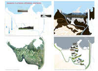
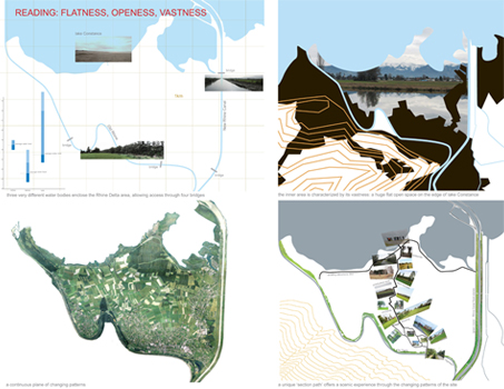
On the other hand, intuitive modes of working, such as site immersion and appraisal, were mixed with conceptual modes of modeling and projection through video, digital modeling and mapping. These different ways of simply - looking - underpinned the first readings of a site that can be perceived as one, as a whole: a huge flat open space defined by three bodies of water. The lake, the Old Rhine and the Rhine Canal are very different in nature, each having its specific water and sedimentation dynamic and connection to the surrounding. The site's uniqueness became even more apparent when perceived in the lake context of which the lakeshore is highly built and mountains rise quickly adjacent to the shoreline. Moving closer to the lake, the inner area's vastness was further emphasized through the gradually changing patterns like the urban orchards followed by productive fields that transform into marshlands all the way to the nature reserve and the shoreline. One is thus aware of the distance to the lake, emphasized by long visibility and openness. The distance becomes an inherent quality of the site. At the same time however, an ongoing and random urbanization is present that is weakening the site's special characteristics.
Planning and Design Process
The site analysis determined a set of data, questions and intentions that needed to be considered when approaching the design. Thorough understanding of the watershed problematic put the construction of a new water trajectory on the agenda. Subsequent alterations of the Rhine Canal made it no longer an efficient system; water flow is expected to increase, which will even aggravate the existing flooding risks and sedimentation problems.
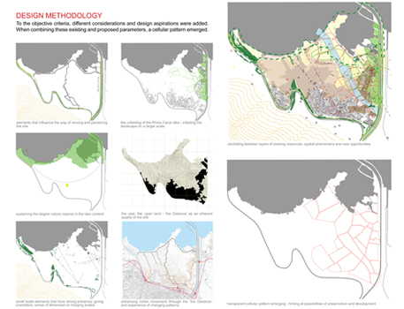
In order to plan the new water trajectory, it is conceived as a path of least resistance: a way of returning space to water by using a minimum of existing resources. Therefore height levels were weighed against the suitability of neighboring parcels for agriculture and further urbanization possibilities. These investigations distilled into a potential gradient of areas, which collided with different considerations and design aspirations, like the unfolding of the canal section - to have this impressive element initiate the landscape on a larger scale, intentions to sustain the nature reserve, thoughts on movement through the site, as well as required infrastructure, program, connections and views. Through the integration of these existing and proposed parameters, a cellular pattern emerged.
This pattern can be seen as a way of characterizing local aspects, values and challenges, and integrating them in the planning process in order to create a system in which environmental and experiential inputs can fully develop. Landscapes often contain unique elements, spatial phenomena or configurations that represent special opportunities for sustainable landscape planning. The cellular pattern enables such design explorations at a finer scale. Different conceptions of landscape are stimulated when the existing is enriched and diversified. They function like a spectrum, hinting at possibilities for preservation and development at the same time.
By moving back and forth between general vision building on a regional scale and specific local qualities and designs, a generic system arises out of local parameters. The parametric cells as spatial development concept and strategy thus narrate an approach rather then offering a finite design. It obviously does not solve every area in the Rhine Delta, nor delivers an immediate plan for implementation. But it brings an approach that possibly allows for the meshing of partial operations with the envisioned overall transformation and restructuring of this site. After all, linking short-term immediate actions with long-term perspectives is crucial in the design of landscapes, especially at this scale, where processes of change are gradual.
Outcome- Addressing the Problems, Creating New Opportunities
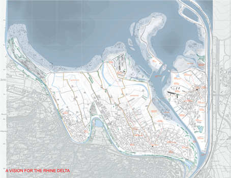
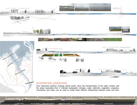
The result is a vision for the Rhine Delta as a whole, composed of a connecting topography layer and structural layers that disclose future design opportunities. These were thought of, designed and brought together mainly through sections. Four transverse sections crossing critical points show the transformation of the trajectory and the areas resonating from it.
The topography layer defines the future relationship of water to land. The future trajectory handles low to extremely high water levels offering a different landscape at different times. Though it is a continuous, one clear gesture, the new trajectory is composed of different cells, with different characteristics. It changes its objectives and parameters along the path, addressing the problematic of flooding and sedimentation in multiple ways, and allowing a diversified and changing landscape to emerge, in time and in space.
The vision's structural layers record the gradually evolving platforms of activity: settlement, agriculture, water, infrastructure and recreation. They reveal how the new trajectory is conceived as an infrastructure that operates beyond its technical section. It induces new landscape qualities: waterscapes that penetrate and restructure the urban by offering new edge conditions, or accommodate the waste water management , reclamation of the Rhine canal as a space for (water-based) leisure activities, attraction of the natural reserve from the lakeshore deeper into the land, scenic pathways, a diversification in vegetation patterns by topographic or sedimentation characteristics, etc.
In this way, Switching trajectories is sustaining local socio-economic activities and detecting latent opportunities to create new resources for future generations.
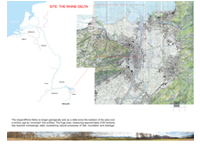
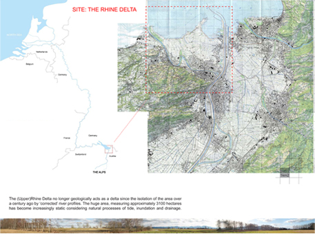
Site: The Rhine Delta. The (Upper) Rhine Delta no longer geologically acts as a delta since the isolation of the area over a century ago by corrected river profiles. The huge area, measuring approximately 3100 hectares has become increasingly static considering natural processes of tide, inundation and drainage.
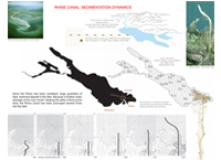
Rhine Canal: Sedimentation Dynamics. Since the Rhine has been canalized, large quantities of Alps sediment deposit in the lake. Because it hinders water passage at the river mouth, keeping the delta a flood prone area, the Rhine Canal has been prolonged several times into the lake.
Reading Flatness, Openness, Vastness
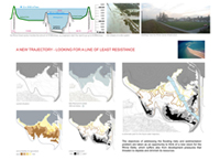
A new trajectory — looking for a line of least resistance
The objectives of addressing the flooding risks and sedimentation problem are taken as an opportunity to think of a new vision for the Rhine Delta, which suffers also from development pressures that threaten to deplete and diminish its resources.
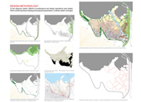
Design Methodology. To the objective criteria, different considerations and design aspirations were added. When combining these existing and proposed parameters, a cellular pattern emerged.
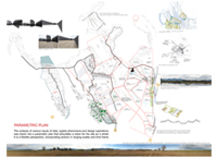
Parametric Plan. The analysis of various inputs of data, spatial phenomena and design aspirations, was drawn into a parametric plan that articulates a vision for the site as a whole. It is a flexible perspective, incorporating actions in ranging scale and time frame.
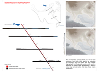
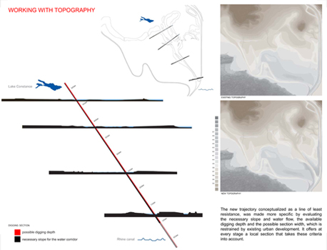
Working with Topography. The new trajectory conceptualized as a line of least resistance, was made more specific by evaluating the necessary slope and water flow, the available digging depth and the possible section width, which is restrained by existing urban development. It offers at every stage a local section that takes these criteria into account.
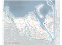
A vision for the Rhine Delta
"Responsible management of dynamic waterways will always be an enormous challenge to designers. The Rhine Delta study in Switzerland and Austria proposes convincing design strategies for accommodating flooding risks and sedimentation issues as the region continues to develop. Jurors acknowledge the beautiful and compelling graphic presentation with its very effective combination of systems analysis and local landscape sectional studies. The jury also acknowledged the projects' admirably succinct method of incorporating both perceptual and factural aspects of site information into the study. What results is a richly layered proposal that embraces change as part of a "cellular" structural pattern for future land use-all within a reimagined Rhine River corridor."
— 2009 Student Awards Jury
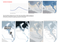
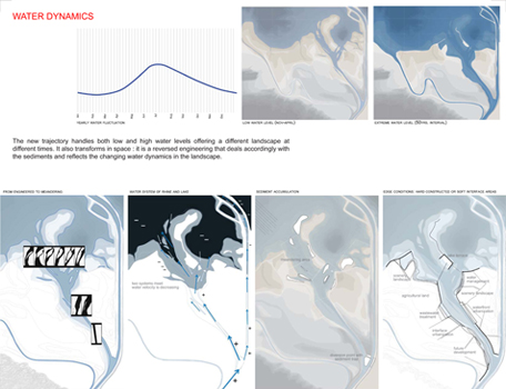
Water Dynamics. The new trajectory handles both low and high water levels offering a different landscape at different times. It also transforms in space: it is a reversed engineering that deals accordingly with the sediments and reflects the changing water dynamics in the landscape.
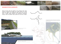
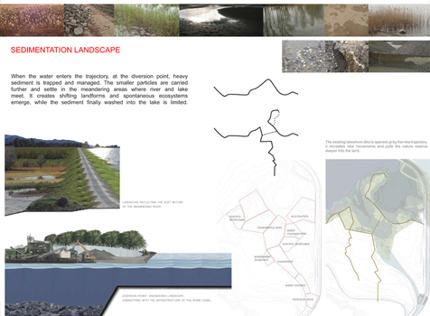
Sedimentation Landscape. When the water enters the trajectory, at the diversion point, heavy sediment is trapped and managed. The smaller particles are carried further and settle in the meandering areas where river and lake meet. It creates shifting landforms and spontaneous ecosystems emerge, while the sediment finally washed into the lake is limited.
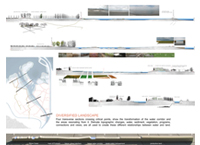
Diversified Landscape. Four transverse sections crossing critical points show the transformation of the water corridor and the areas resonating from it. Delicate topographic changes, water, sediment, vegetation, programs, connections and views, are all used to create these different relationships between water and land.
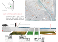
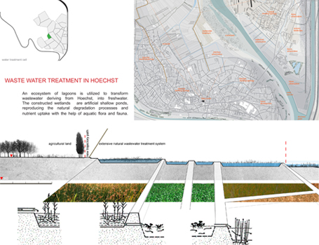
Waste Water Treatment in Hoechst. An ecosystem of lagoons is utilized to transform wastewater deriving from Hoechst, into freshwater. The constructed wetlands are artificial shallow ponds, reproducing the natural degradation processes and nutrient uptake with the help of aquatic flora and fauna.
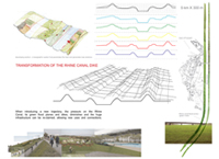
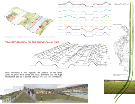
Transformation of the Rhine Canal Dike. When introducing a new trajectory, the pressure on the Rhine Canal, its green flood planes and dikes, diminishes and the huge infrastructure can be re-claimed, allowing new uses and connections.
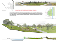
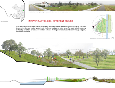
Initiating Actions on Different Scales. The canal dike is transformed to include pathways and more delicate slopes. An existing orchard is then continued on the dike and into the green rivers, the former flood planes of the canal. The result is the broadening of the edge condition creating new relations between dwellings, infrastructure and water through program, movement and views.
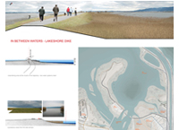
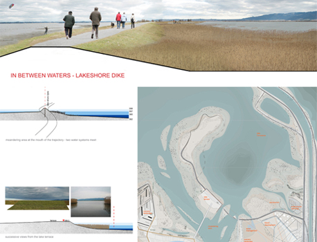
In Between Waters — Lakeshore Dike
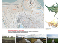
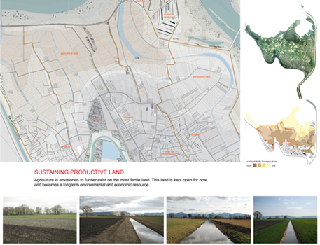
Sustaining Productive Land. Agriculture is envisioned to further exist on the most fertile land. This land is kept open for now, and becomes a longterm environmental and economic resource.