

«previous pageGENERAL DESIGN CATEGORY
Reconciling Purity and Nature: A Bathing Pool for Daingerfield Island
Allison Thurmond, Student ASLA
Virginia Tech Washington Alexandria Architecture Consortium, Alexandria, VA
faculty advisors: Paul Kelsch, Ph.D., ASLA, and Paul Emmons, Ph.D., RA
Project Statement
This project reinterprets an outdoor swimming hole. It uses ecological processes coupled with an elegant use of ancient, low-tech hydraulics to purify the polluted water of the Potomac River for use in a bathing pool set amidst a restored natural forest. This project demonstrates the potential for restoring a degraded landscape for use by urban dwellers without overly civilizing nature and thereby destroying that which attracts us to it in the first place.
Project Description
Site
Daingerfield Island lies along the western shore of the Potomac River, just south of National Airport , northeast of the city of Alexandria, and bounded on its western side by the George Washington Parkway. The 107 acre property supports a variety of uses: a marina, restaurant, and playing fields on the northern section, a National Park Service maintenance complex and equipment yard in the center of the site, and untended forest land along the western edge to the southern tip of the site. The Mt. Vernon Bike Trail runs along the western edge of the site, connecting it to parks all along the Potomac. The majority of the site is overgrown with invasive vines and largely unused. Crime is a perceived problem, but few actual incidents occur.
Program
The studio's program called for an aquatic center, a way of inhabiting water on the site. A so-called island in the Potomac, this program presented a tension between water for habitation and the polluted river itself. Rejecting the controlled and sterile environment of the modern swimming pool, I interpreted this program into a bathing and swimming complex that reinterprets the simplicity of swimming outdoors.
Water
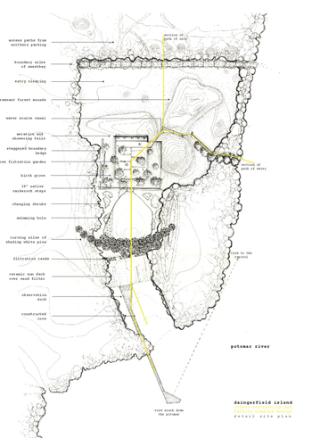
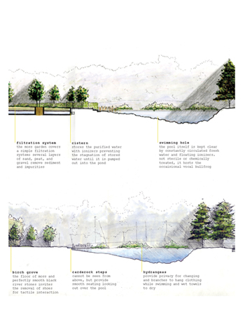
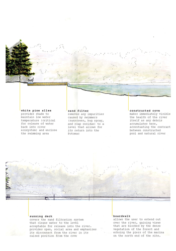
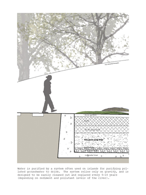
The palette of water allowed for an exploration of low-tech hydraulics and simple mechanics to accomplish the goal of cleaning water to swim in, and cleaning it again to return it into the Potomac as elegantly and possible. This precluded the need for disturbing the forest to run water, sewer, and electrical lines through the forest to the rather remote site of the bath. Instead, the water is visibly pulled from the Potomac, brought uphill in a series of terraced channels by means of the ancient Greek Heron's Fountain, which raises the water 6" at a time only by its own hydrostatic pressure. Having reached a high point in the site, the water falls through a series of branching channels into a moss garden, built over a peat and sand filter based on island drinking water purification systems, being cleaned as it filters down into a storage cistern. From here it falls slowly into a constructed swimming hole, kept cool by a southern alleé of White Pines and algae free by floating solar ionizers. Water from the pool is pumped into reed beds that remove any sediment and organic material before flowing under a sunning deck into a sand filter, which cleans the water to the standards required by the EPA to release into a public water way. Finally, the water is visibly returned to the river, in a constructed cove that can be seen but not directly accessed, acknowledging its polluted nature.
Forest
"Forest" from the Latin foras [related to foreign] or Old French foris [meaning "outside" or "other".
"Park" from the Latin parricus [meaning enclosure]. Defined by possession of a solid, impermeable boundary. Controlled and policed inside, behavior and program strictly designed.
The forest is regarded as a place of liberty, without distinct boundaries. It possesses a sense of open-endedness and permeability, and encourages a means of inhabitation unlike that of designed landscape. Historically a place of both lawlessness and freedom, the forest encapsulated both the danger and enchantment of uncontrolled space. The existing forest on Daingerfield Island holds true to this tradition. Existing in the center of urban development, it retains a sense of "other," seeming to be vastly separate from the city around it. The forest is overgrown with invasive vines (largely Japanese honeysuckle and English ivy) to the point of choking out its trees. Designing within it presented the challenge of restoring the forest without civilizing or controlling it.
Memory
The existing forest is unhealthy in its ecology, but beautiful in its own distinct way. Ropes of honeysuckle and wild rose choke out existing trees, but their blossoms perfume the area midsummer and provide an alternate view of nature: neither balanced wilderness nor tended garden. The vines also blanket three large mounds rising from the flat topography of the site that are similarly vague in origin. Remnants of National Park building materials- mulch, soil, and wood chips- the mounds read as conspicuous additions to the topography of the the site. With their cover of vines and forest vegetation, the human building material has been reclaimed as part of the "natural" site. They are preserved in the final design, isolated as three floating hills in a clearing of gravel that protects the forest from the return of the invasive, but fragrant, vines that maintain their claim.
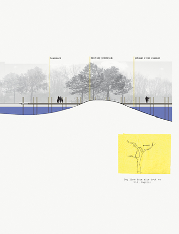
The project is designed as a series of interventions in the forest, playing with the idea of boundary and control of scale of space without ever creating an impermeable edge. The project moves from the horizontally defined but vertically open gravel clearing with vine covered mounds as objects in the space to the enclosed paths between the mounds, opening again into the low-ceilinged birch grove shading the moss garden. Stone walls cut into the mounds changing them from freestanding objects to defining edges. From the end of the garden, the view opens out over the swimming hole, again open to the sky but enclosed by the steps leading down to it and the forest around it. Through the dense alleé at its southern edge, the view opens again across the sunning deck and cove, with a hint of the river beyond. One must venture out onto the boardwalk over the river to experience the full openness of the river, with views miles north to the dome of the Capitol and south down the river.
Materiality
The materiality of the bathing complex mirrors the progression from fully clothed and protected to the exposure of skin. The floor of the first clearing is sharp Carderock (a local quarry) gravel, changing to a rounder, kinder gravel where the human path first meets the bathing water in the center of the remnant mounds. Shoes are invited to be removed upon entering the moss garden, where the paths are smooth black river stone and the moss springs underfoot. Large cullets, boulder-like reclaimed glass masses, replace the stones traditionally punctuating moss gardens and reference the water purified in and stored under the grove. Down the wide, smooth Carderock step to the swimming hole the materials soften again, to smooth lawn, round river stones, and thickets of hydrangeas that provide privacy for changing and branches to hang clothing. At the southern end of the pond, a double alleé of white pine provides a spongy floor of thick needles, separating the swimming area from the sunning deck. Built over the sand filter that purifies the water again before releasing it back into the Potomac, the deck mirrors the glass over the first purification filter (in the moss garden) with long strips of translucent glass set into its surface. The deck itself is made of offset 4' x 7' slabs of white, textured ceramic. Sized relative to the people who will lay on them, they define a personal boundary and allow the surface to be easily taken up and replaced when the filtration device required maintenance. The aging wooden surface of the boardwalk that extends out over the Potomac suggests replacing protective clothing, as the privacy of the forest complex gives way to views both up and down the Potomac .
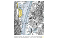
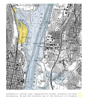
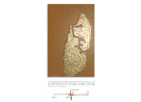
Bathymetric context map: daingerfield island, northern Old Town Alexandria, VA and the southern tip of the District of Columbia.
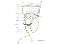
Daingerfield island detail site plan
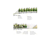
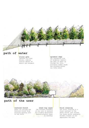
Path of water/Path of the user
Path of water/Path of the user
Path of water/Path of the user
Path of water/Path of the user
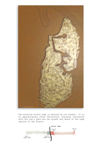
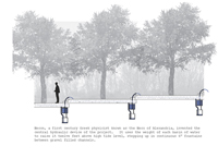
The existing forest edge is defined by its shadow. It is an appropriately fluid definition, changing constantly with the suns path and the growth and death of the edge species of the forest.

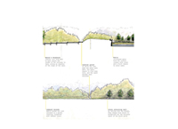
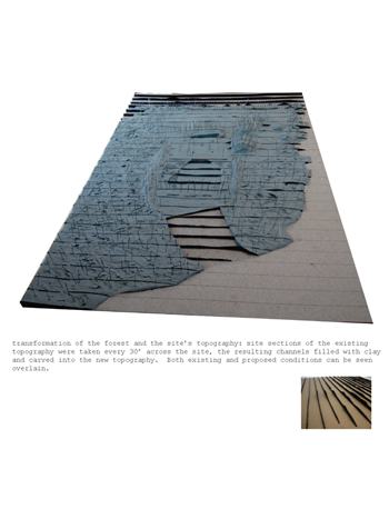
Transformation of the forest and the sites topography: site sections of the existing topography were taken every 30 across the site, the resulting channels filled with clay and carved into the new topography. Both existing and proposed conditions can be seen overlain.
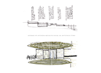
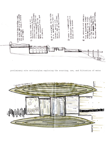
Preliminary site section/plan exploring the sourcing, use, and filtration of water.
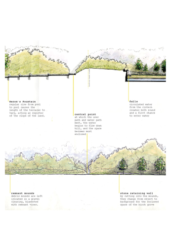
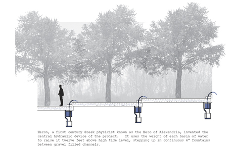
Heron, a first century Greek physicist known as the Hero of Alexandria, invented the central hydraulic device of the project. It uses the weight of each basin of water to raise it twelve feet above high tide level, stepping up in continuous 6 fountains between gravel filled channels.
"One of the most intriguing and thoughtful site-specific projects we saw. They were not afraid to design a garden or to draw a very sensitive design by hand. The research was remarkable and they actually used plants purposefully and sculpturally."
— 2009 Student Awards Jury

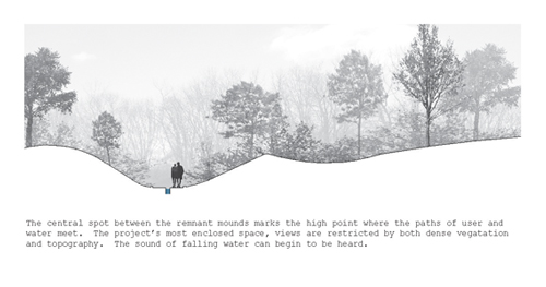
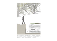
The central spot between the remnant mounds marks the high point where the paths of user and water meet. The projects most enclosed space views are restricted by both dense vegetation and topography. The sound of failing water can begin to be heard.
Water is purified by a system often used on islands for purifying polluted groundwater to drink. The system relies only on gravity, and is designed to be easily cleaned out and replace every 5-10 years (depending on sediment and pollutant levels of the river).

Daingerfield island cove section: 1/32 1
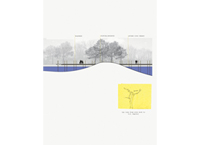
Ley line from site dock to U.S. Capitol
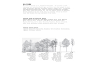
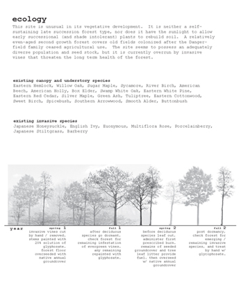
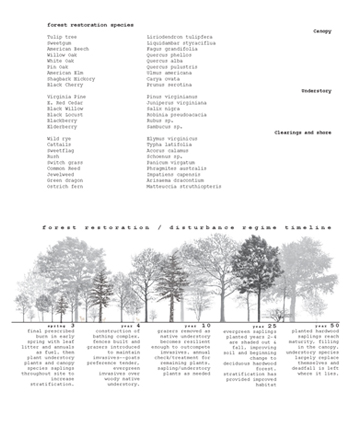
Ecology This site is unusual in its vegetative development. It is neither a self-sustaining late succession forest type, nor does it have the sunlight to allow early successional (and shade intolerant) plants to rebuild soil. A relatively even-aged second growth forest covers old fields colonized after the Dangerfield family ceased agricultural use. The site seems to possess an adequately diverse population and seed stock, but it is currently overrun by invasive vines that threaten the long term health of the forest.
Ecology This site is unusual in its vegetative development. It is neither a self-sustaining late succession forest type, nor does it have the sunlight to allow early successional (and shade intolerant) plants to rebuild soil. A relatively even-aged second growth forest covers old fields colonized after the Dangerfield family ceased agricultural use. The site seems to possess an adequately diverse population and seed stock, but it is currently overrun by invasive vines that threaten the long term health of the forest.