

«previous pageANALYSIS & PLANNING CATEGORY
Rejuvenating the Channel-Scape: Wanquan Stream Channel Multi-Functional Planning and Design
University of Minnesota, Twin Cities campus, MN
faculty advisors: Robert Sykes, ASLA; Joseph Favour; Lance Neckar, ASLA, and
Vincent deBritto
Project Statement
Wanquan stream, which is a straightened, concrete covered and spatially constrained urban channel, flows 8 km through an historically meaningful, while quickly urbanizing area in northwest Beijing. Facing with the complicated ecological, historical and urban issues, the regenerative design approach goes beyond stream restoration to address the varied and interweaving problems of the stream channel within a larger context in light of green infrastructure and landscape urbanism. The water system and open space system reintegration are the key elements in the planning phase and also help to generate the different channel types. The whole process of planned design tries to set up a working framework that could be used for similar projects in the future.
Project Narrative
Analysis
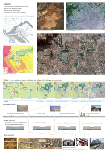
Beijing's Haidian district is in a transient landscape between the west mountains and east plain, brilliant history and intriguing future, deteriorating eco-conditions and quick urbanization. Wanquan river is a thread linking these together. The abundance of springs and ground water in this area had brought in a prosperous garden culture in history. To the end of the 18th century, numerous gardens have been built including the summer palace, the Changchun garden (which is the current site of Peking University) and Yuanming Yuan- the largest garden cluster in history and the peak of China's garden art. Flowing across this historical area, Wanquan stream provided water for these gardens. The numerous springs and high ground water level infused the Wanquan stream in the past. The name of Wanquan stream literally means stream with ten thousand springs.
After the burning and destroy by war in 1860, the gardens were gone. However, a lot of man-made landscape ruins have left till today which influenced the spatial configurations and landscape of the area. In the early 20th century, universities began to be built on some of the garden ruins including Yanching University and Tsinghua University. After 1949, this area has been planned as university district. The pressure of development has increased ever since. In the past, the dominant landscape in this area is agriculture dotted with gardens. However, as the population increase, the matrix landscape began to change. The overuse of groundwater has depleted all the underground springs gradually after 1950s. The significant drop of groundwater level has altered the local environment forever.
This area remains suburb until the middle of 1990s. In the last ten years, the pressure of growing population and development has increased dramatically and the nearby area has become more and more urbanized. The natural climate of Beijing makes the environmental situation even worse as the precipitation is smaller than the evaporation. Besides the low groundwater level always dries the river or pond bed by infiltration, making them hard to sustain water. The last rice field in this area was razed in around 2001 putting an end to the unique landscape and tradition. After the springs get dry, the city has to provide water from the reservoir to the stream several times in a year. In the 1990s, the stream become very polluted due to the sewage and then the river got straightened, chanalized and covered in concrete. In recent years, facing more serious shortage of water, the city has decreased the amount and frequency of water to the stream or even stopped providing water. The deep concrete stream channel becomes an unpleasant and neglected place in this area.
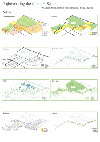
The history of this area is a co-evolution of culture (gardens, university as patches), stream (as corridor) and landscape (agriculture as matrix). Today, the balance among them is broken. Based on the analysis of history, the project looks further on the current land use, property, circulation, Pedestrian access, water system, open space system, buildings and channel conditions to understand the constrains and potential of the site. Data, photos and site experiences were collected from different year's site visits and survey. The concrete cover runs the entire length of the stream with steep and straight banks. The stream is normally 3-5 meters wide, 2-4 meters deep. Water flow level is very low most of the year. Sometimes it is completely empty. The space along the stream is very constrained with roads and walls surrounding it. Besides some bike trails, there are very few people come close to the stream waterfront despite the fact that public open space is much needed in this area. The current stream channel functions more like a deteriorated ditch that separating the space on different sides.
Goal and Objectives
Due to the highly constrained space, controlled water source and artificial channel conditions, it's impossible to do a regular stream restoration here. The normal urban landscape design is not enough to solve the eco and social problems either. Multi-functional goals need to be set up with interdisciplinary approaches to transform the stream channel into an urban green infrastructure which is ecologically healthy, aesthetically pleasant and socially integrating. The open space and landscape of the stream will not only filter the water, enhance the ecological functions and aesthetics of the stream, but also tell the history of the site, demonstrate the ecological principles and water cycle of stream, providing public education together with recreation. The planning and design will focus on the channel and its waterfront space based on the analysis on a broader scope. The lack and low quality of water and open space were the most important issues to address. The channel rejuvenating will focus on the bank renovation to link planning and design seamlessly. This process will be a experiment in small urban stream channel rejuvenating and a paradigm in landscape urbanism.
Planning Strategy
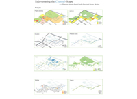
Based on the analysis of the larger context and the site conditions, the planning will focus on the water and open space. The water source and quality problem in the stream channel as well as in the watershed is the first thing to look at. Facing the problem of less precipitation than evaporation, uneven distribution
of rainfall and drop of ground water level, the proposal is to reuse grey water as the major continual water source for the stream and ponds while also capturing the storm water by different techniques. The population increase will use more water on one hand, while also generate more grey water on another hand which could be used to keep the water balance if there is adequate space and techniques for treatment. According to the plan, the grey water will normally go through three phases of treatment from living machine (which is supposed to get rid most of the pollutant), to the pond, wetland system (which are largely left from historical gardens and needs to be reconnected to the stream) and finally to the stream channel for further treatment. Some water will also infiltrate to improve the ground water conditions. The water in the stream will provide water source for Yuanming Yuan once again like in history, while other will flow into Qing river in the end. In terms of storm water capture, the watershed which is highly urbanized is based mostly on artificial boundary like roads. There are five types of sub-watershed defined based on land use types: open space, modern residential , traditional residential, traditional campus, modern campus. Different storm water management techniques will be combined into different sub-watershed types. A water budget balance is worked out to make sure the water cycle is going in the right way. The capture and treatment facilities can be well integrated with the buildings and existing water body. The research capabilities and sustainable initiative of the nearby universities which have been hoping to clean the stream water separately for long will greatly facilitate this endeavor.
All the different open space near the stream will be classified and enhanced from the totally hardscape of square to the large city park. A typology study was performed before the planning. There are three major groups of open space according to its morphology: the small patch space, large space and linear space. The small patch space includes the apartment yards, green space in front of the buildings, traditional house courtyard, squares in front of buildings. The large space include campus, ruin park, public green, golf, city park and sports ground. The linear space includes boulevard, waterfront walk and gully. This typology study is used to discern and integrate all the existing and potential open space along the stream. By these interventions the waterfront of the stream will connect the nearby open space into a system that is identical, productive and refreshing. This continual space will function as an urbanism catalyst that will bring different people to the stream waterfront.
Planned Design
In this phase, the project will further narrow down and focus on the redesign of the stream channel itself and the most immediate waterfront space. The channel will be programmed as a multi-functional green infrastructure flowing through the historical area. It will be a water filtering system further treating the water, rehabilitated channel with improved ecological functions, a reminiscent of history, a linear urban landscape with refreshing waterscape, waterfront space for narrative, education and recreation. Although the space along the stream is limited, the design will try to provide waterfront sidewalk, bike trail, path, bridges, waterscape features, small public green and parks along it. The plan form and location of the current stream will be largely kept. But the stream channel will be reshaped especially through the redesign of the cross sections. As it flows to the end with relatively more space left, the design will allow for more undulating or even braided forms. Some connections with the nearby pond system and parks will be also added.
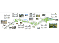
A series of stream channel types will be generated based on the former planning intervention and goals. The major deciding elements of the channel types are the immediate waterfront space, its space type, style, spatial edge, width etc. But there are also other related elements influencing the section types, including history, ecological requirements, recreational functions. Seven channel types are generated from this typology matrix method. The differences of each channel types are defined in its plan type, bank type, width and depth. Three types of channel plan are defined: straight, curved (can be slightly curved or undulating), braided mostly depending on the space limitation. Four types of banks are designed on either side of different portions of the channel: wall, terrace, stonework, natural slopes depending on the space, history, style and functional elements. The seven different channel section types divide the channel into seven zones. There are also some important nodes along the channel which marks the start or end points, provide transient between different section types or constitute important landmark or landscapes.
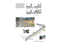
This generative process of channel types links analysis, planning and design together. It can go further into the design development and detail design based on this method and framework. Plan drawings, sections and perspective renderings helps further develop the channel design. In this project, there is a strong logic connections between the planning and design. The analysis and planning frameworks were delivered into the design ideas to ensure that the channel will functions well and different channels are well integrated into a system. The planning framework not only regulates the spatial layout and functions of the stream but also provides logic basis of channel type and design guidelines that can apply into the future design. This process also allows for freedom, flexibility and in-depth development of design that will help to translate planning into implementation.
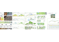
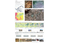
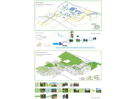
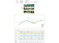
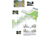
Overview of analysis and planning (Photo: Xuan Lu)
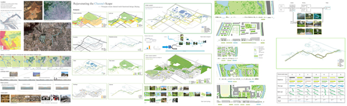
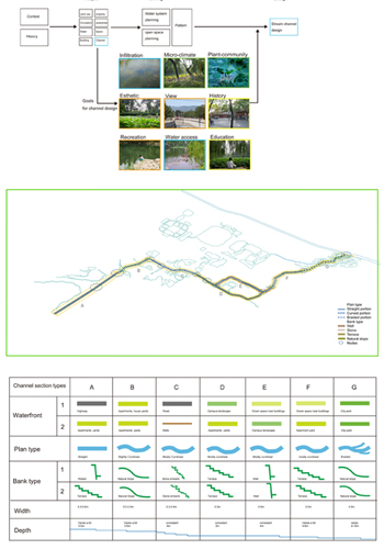
Overview of planned design (Photo: Xuan Lu)
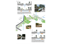
The context of Wanquan stream and the co-evolution of landscape, stream and culture. The water problem is shown in the diagram. (Photo: Department of Geography,
Peking University and Xuan Lu)
Analysis of existing land use, property ownership, circulation, pedestrian access, water, open space, buildings and channel conditions helps better understanding the constrains and potential of the stream. (Photo: Xuan Lu)
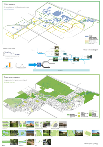
Planning strategy of water and open space system. Strategy of grey water reuse through three phase of treatment and storm water capture as the source for the stream will solve the most urgent problem of the stream. Reintegrating different open space base on the space typology study will create an continual and diversified waterfront along the stream. (Photo: Xuan Lu)
Further explanation of the watershed types and related grey water/ storm water strategies. (Photo: Xuan Lu)
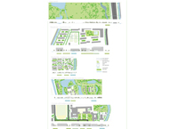
Generative Process of different channel types based on water strategy and waterfront types from planning. The different types of channels are described in plan type, bank type, width and depth. (Photo: Xuan Lu)
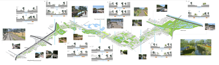
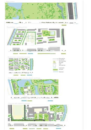
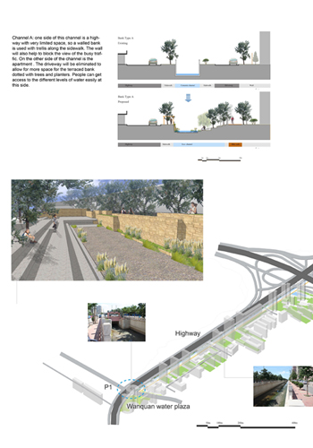
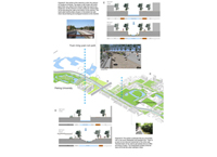
Channel A: one side of this channel is a highway with very limited space, so a walled bank is used with trellis along the sidewalk. The wall will also help to block the view of the busy traffic. On the other side of the channel is the apartment . The driveway will be eliminated to allow for more space for the terraced bank dotted with trees and planters. People can get access to the different levels of water easily at this side. (Photo: Xuan Lu)
"Sophisticated thinking about humans and landscape systems. It proves the lie of destructive development, that you can improve by undoing. "
— 2009 Student Awards Jury
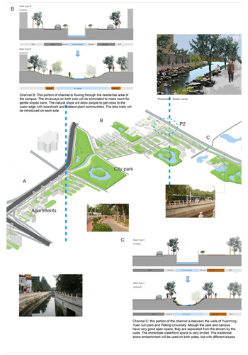
Channel B: This portion of channel is flowing through the residential area of the campus. The driveways on both side will be eliminated to make room for gentle sloped bank. The natural slope will allow people to get close to the water edge with boardwalk and wetland plant communities. The bike trails will be introduced on each side. Channel C: this portion of the channel is between the walls of Yuanming Yuan ruin park and Peking University. Altough the park and campus have very good open space, they are seperated from the stream by the walls. The immediate waterfront space is very limited. The traditional stone embankment will be used on both sides, but with different slopes. One side is more steep, close to the road. The other side is more gentle, allowing for walking down to the water edge. (Photo: Xuan Lu)
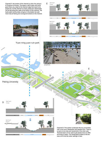
Channel D: This portion is between the two universities with a very busy intersection and people's flow. There is a road on one side and residential on the other side. Terraced bank will be used to get people down to different levels of stairs. The hardscaped surface of the terrace will fit into the urban settings in here. Channel E: this portion of the channel is within the campus of Tsinghua University. The space is still limited with some good trees very close to the channel edge that need to be preserved. So the channel is mostly preserved. Boardwalks will be laid along the walls at the bottom of the channel. The hydro plant communities will grow in the bottom too add more natural feeling and ecological functions to the channel. (Photo: Xuan Lu)
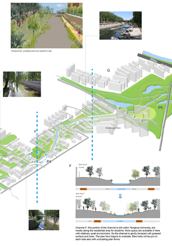
Channel F: this portion of the channel is still within Tsinghua University, but mostly along the residential area for students. More space are available in here with relatively quiet environment. So the channel is gently terraced with grassed surface and trees. The plan form begins to undulate. Bike trails will be put on each side also with undulating plan forms. (Photo: Xuan Lu)
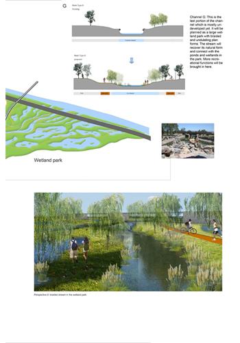
Channel G: This is the last portion of the channel which is mostly undeveloped yet. It will be planned as a large wetland park with braided and undulating plan forms. The stream will recover its natural form and connect with the ponds and wetlands in the park. More recreational functions will be brought in here. (Photo: Xuan Lu)